File:Allied Invasion Force.jpg
Jump to navigation
Jump to search

Size of this preview: 785 × 599 pixels. Other resolutions: 314 × 240 pixels | 629 × 480 pixels | 1,006 × 768 pixels | 1,265 × 966 pixels.
Original file (1,265 × 966 pixels, file size: 561 KB, MIME type: image/jpeg)
Captions
Captions
Add a one-line explanation of what this file represents
Summary[edit]
| Description |
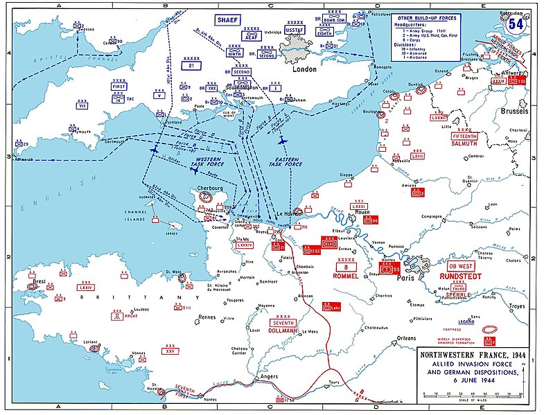
English: Allied invasion plans and German positions in Normandy.
Deutsch: Alliierte Invasionspläne und deutsche Positionen zur Invasion in der Normandie. |
| Date | Unknown date |
| Source/Photographer | http://www.dean.usma.edu/history/Atlases/WorldWarTwoEurope/EuropeanTheaterGIF/WWIIEurope54.gif |

|
This military map image could be re-created using vector graphics as an SVG file. This has several advantages; see Commons:Media for cleanup for more information. If an SVG form of this image is available, please upload it and afterwards replace this template with
{{vector version available|new image name}}.
It is recommended to name the SVG file “Allied Invasion Force.svg”—then the template Vector version available (or Vva) does not need the new image name parameter. |


Licensing[edit]
This image is a work of a U.S. military or Department of Defense employee, taken or made as part of that person's official duties. As a work of the U.S. federal government, the image is in the public domain in the United States.
|
 |
derivative works[edit]
Derivative works of this file: Allied Invasion Force Hebrew.png
| Annotations | This image is annotated: View the annotations at Commons |
File history
Click on a date/time to view the file as it appeared at that time.
| Date/Time | Thumbnail | Dimensions | User | Comment | |
|---|---|---|---|---|---|
| current | 15:33, 30 November 2012 | | 1,265 × 966 (561 KB) | Hohum (talk | contribs) | Cleanup |
| 01:05, 27 May 2005 |  | 1,265 × 966 (188 KB) | Legion~commonswiki (talk | contribs) | Allied invasion plans and german positions in the Normandy. {{PD-USGov-Military}} Category:World War II |
You cannot overwrite this file.
File usage on Commons
The following 4 pages use this file:
File usage on other wikis
The following other wikis use this file:
- Usage on als.wikipedia.org
- Usage on ar.wikipedia.org
- Usage on ast.wikipedia.org
- Usage on azb.wikipedia.org
- Usage on bg.wikipedia.org
- Usage on bn.wikipedia.org
- Usage on ca.wikipedia.org
- Usage on cs.wikipedia.org
- Usage on da.wikipedia.org
- Usage on de.wikipedia.org
- Usage on de.wikibooks.org
- Usage on el.wikipedia.org
- Usage on en.wikipedia.org
- Juno Beach
- Sword Beach
- Normandy landings
- Cotentin Peninsula
- Gold Beach
- 29th Infantry Division (United States)
- Fortress Europe
- Military career of Dwight D. Eisenhower
- Wikipedia talk:WikiProject Military history/Archive 20
- Operation Overlord
- D-Day (military term)
- Wikipedia:Articles for creation/2007-05-06
- American airborne landings in Normandy
- Portal:France/Featured Article Archive/2006
- User:Climie.ca/Sandbox/Normandy
View more global usage of this file.