File:Alençon Alto public transport 2007 map-fr.svg
From Wikimedia Commons, the free media repository
Jump to navigation
Jump to search

Size of this PNG preview of this SVG file: 600 × 600 pixels. Other resolutions: 240 × 240 pixels | 480 × 480 pixels | 768 × 768 pixels | 1,024 × 1,024 pixels | 2,048 × 2,048 pixels | 1,417 × 1,417 pixels.
Original file (SVG file, nominally 1,417 × 1,417 pixels, file size: 250 KB)
File information
Structured data
Captions
Captions
Add a one-line explanation of what this file represents
Summary[edit]
| DescriptionAlençon Alto public transport 2007 map-fr.svg |
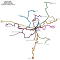
English: Map of regular public transport lines in Alençon in 2007. Alençon, Orne, Basse-Normandie, France.
Français : Plan des lignes régulières des Transports urbains de la communauté urbaine d'Alençon en 2007. Alençon, Orne, Basse-Normandie, France. |
||
| Date | (UTC) | ||
| Source | Reseau Aleo.svg | ||
| Author | |||
| Attribution (required by the license) InfoField | © Sémhur / Wikimedia Commons / | ||
InfoField | © Sémhur / Wikimedia Commons | ||
| SVG development InfoField |
|
| Object location | 48° 25′ 50.16″ N, 0° 05′ 35.16″ E | View this and other nearby images on: OpenStreetMap |
|---|
Licensing[edit]
I, the copyright holder of this work, hereby publish it under the following license:
| Public domainPublic domainfalsefalse |
| I, the copyright holder of this work, release this work into the public domain. This applies worldwide. In some countries this may not be legally possible; if so: I grant anyone the right to use this work for any purpose, without any conditions, unless such conditions are required by law. |
Original upload log[edit]
This image is a derivative work of the following images:
- Reseau Aleo.svg licensed with PD-self, PD-self/fr
- 2010-01-12T19:44:24Z Sémhur 1417x1417 (256508 Bytes) + legend, date & station labels
- 2008-06-16T11:00:43Z Daiima 1417x1417 (352176 Bytes) {{Information |Description= |Source= |Date= |Author= |Permission= |other_versions= }}
- 2008-06-16T10:51:44Z Daiima 1386x1333 (349901 Bytes) {{Information |Description={{en|1=Alençon's bus network map }} {{fr|1=Plan du réseau Aléo d'Alençon}} |Source=travail personnel (own work) |Author=[[User:Daiima|Daiima]] |Date=16 juin 2008 }}
Uploaded with derivativeFX
File history
Click on a date/time to view the file as it appeared at that time.
| Date/Time | Thumbnail | Dimensions | User | Comment | |
|---|---|---|---|---|---|
| current | 17:51, 22 January 2010 |  | 1,417 × 1,417 (250 KB) | Sémhur (talk | contribs) | == {{int:filedesc}} == {{Information |Description= {{en|Map of regular public transport lines in Alençon in 2007. Alençon, Orne, Basse-Normandie, France.}} {{fr|Plan des lignes régulières des [[:fr:Transports urbains de la communauté |
You cannot overwrite this file.
File usage on Commons
The following page uses this file:
File usage on other wikis
The following other wikis use this file:
- Usage on fr.wikipedia.org
- Usage on www.wikidata.org
Structured data
Items portrayed in this file
depicts
22 January 2010
48°25'50.2"N, 0°5'35.2"E
image/svg+xml
67acc39c42c2216e399b587a67a4411320f9a174
256,508 byte
1,417 pixel
1,417 pixel
Hidden categories: