File:Alberta Highway 11 Map.png
Jump to navigation
Jump to search

Size of this preview: 356 × 600 pixels. Other resolutions: 142 × 240 pixels | 557 × 938 pixels.
Original file (557 × 938 pixels, file size: 117 KB, MIME type: image/png)
Captions
Captions
Add a one-line explanation of what this file represents
Summary[edit]
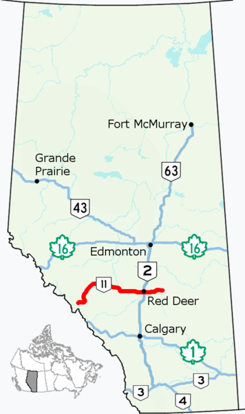
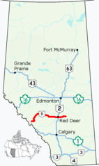
| Description | Alignment of Highway 11 in Alberta, Canada. |
| Source |
This file was derived from: Alberta Highway 002.png
|
| Author |
Licensing[edit]
I, the copyright holder of this work, hereby publish it under the following license:
This file is licensed under the Creative Commons Attribution 4.0 International license.
- You are free:
- to share – to copy, distribute and transmit the work
- to remix – to adapt the work
- Under the following conditions:
- attribution – You must give appropriate credit, provide a link to the license, and indicate if changes were made. You may do so in any reasonable manner, but not in any way that suggests the licensor endorses you or your use.
File history
Click on a date/time to view the file as it appeared at that time.
| Date/Time | Thumbnail | Dimensions | User | Comment | |
|---|---|---|---|---|---|
| current | 15:28, 6 August 2017 | | 557 × 938 (117 KB) | AceYYC (talk | contribs) | {{Information |Description=Alignment of Highway 11 in Alberta, Canada. |Source={{Derived from|File:Alberta Highway 002.png}} *Simplified and optimized by Acefitt. |Author=*Original image (CC-BY-4.0): Hwy43 *Der... |
You cannot overwrite this file.
File usage on Commons
The following 2 pages use this file:
File usage on other wikis
The following other wikis use this file:
- Usage on de.wikipedia.org
- Usage on en.wikipedia.org