File:Alaska boroughs and census areas 2013-19.svg
Jump to navigation
Jump to search

Size of this PNG preview of this SVG file: 800 × 452 pixels. Other resolutions: 320 × 181 pixels | 640 × 362 pixels | 1,024 × 579 pixels | 1,280 × 723 pixels | 2,560 × 1,446 pixels | 816 × 461 pixels.
Original file (SVG file, nominally 816 × 461 pixels, file size: 334 KB)
Captions
Captions
Add a one-line explanation of what this file represents
Summary[edit]
| Description |
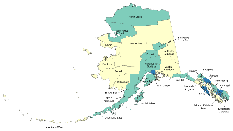
English: Map of boroughs and census areas in Alaska. Green=boroughs, Blue=consolidated city-boroughs, Yellow=census areas (unorganized borough). |
| Date | |
| Source | Own work |
| Author | Lasunncty |
Made with data from the US Census Bureau.
Licensing[edit]
I, the copyright holder of this work, hereby publish it under the following license:
This file is licensed under the Creative Commons Attribution-Share Alike 3.0 Unported license.
- You are free:
- to share – to copy, distribute and transmit the work
- to remix – to adapt the work
- Under the following conditions:
- attribution – You must give appropriate credit, provide a link to the license, and indicate if changes were made. You may do so in any reasonable manner, but not in any way that suggests the licensor endorses you or your use.
- share alike – If you remix, transform, or build upon the material, you must distribute your contributions under the same or compatible license as the original.
File history
Click on a date/time to view the file as it appeared at that time.
| Date/Time | Thumbnail | Dimensions | User | Comment | |
|---|---|---|---|---|---|
| current | 10:30, 2 June 2020 | | 816 × 461 (334 KB) | Lasunncty (talk | contribs) | Reverted to version as of 04:02, 14 December 2016 (UTC) - Confused Petersburg Census area with Petersburg Borough |
| 12:37, 1 June 2020 |  | 816 × 461 (477 KB) | BorderRegions (talk | contribs) | Fixed Petersburg Borough borders, and Hoonah–Angoon Census Area border - both of which did not have included all their appropriate territory. Previous two versions didn't actually register changes. | |
| 11:49, 1 June 2020 |  | 1,168 × 648 (246 KB) | BorderRegions (talk | contribs) | Fixed Petersburg Borough borders, and Hoonah–Angoon Census Area border - both of which did not have included all their appropriate territory. | |
| 11:40, 1 June 2020 |  | 1,168 × 648 (124 KB) | BorderRegions (talk | contribs) | Fixed Petersburg Borough borders, and Hoonah–Angoon Census Area border - both of which did not have included all their appropriate territory. | |
| 04:02, 14 December 2016 |  | 816 × 461 (334 KB) | Kingofthedead (talk | contribs) | Kusilvak | |
| 09:00, 9 June 2015 |  | 816 × 461 (334 KB) | Lasunncty (talk | contribs) | Corrected Haines and Yakutat. Not actually unified government despite their names. | |
| 09:18, 24 December 2014 |  | 816 × 461 (334 KB) | Lasunncty (talk | contribs) | New map as of Jan 2013 |
You cannot overwrite this file.
File usage on Commons
The following 2 pages use this file:
File usage on other wikis
The following other wikis use this file:
- Usage on de.wikipedia.org
- Usage on zh.wikipedia.org