File:Alaska Yukon British Columbia 58to62N 133to143W Topo Rainbow Zebra 2550.jpg
Jump to navigation
Jump to search

Size of this preview: 800 × 320 pixels. Other resolutions: 320 × 128 pixels | 640 × 256 pixels | 1,024 × 410 pixels | 1,280 × 512 pixels | 2,560 × 1,024 pixels | 12,000 × 4,800 pixels.
Original file (12,000 × 4,800 pixels, file size: 38.18 MB, MIME type: image/jpeg)
Captions
Captions
Add a one-line explanation of what this file represents
Summary[edit]
| Description |
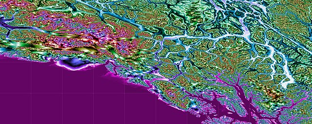
English: This topographic map shows southeastern Alaska, southern Yukon Territory, and the northwestern corner of British Columbia. The map extends from 58 to 62 degrees north latitude and from 133 to 143 degrees west longitude. Produced with Map Render 3D from GHz Limited. Then used IrfanView to stitch together multiple maps. |
| Date | |
| Source | [3 arc second Digital Elevation Models obtained from the website http://www.viewfinderpanoramas.org/dem3.html] |
| Author | Jonathan de Ferranti |
Licensing[edit]
| This file is in the public domain in the United States because it was solely created by NASA. NASA copyright policy states that "NASA material is not protected by copyright unless noted". (See Template:PD-USGov, NASA copyright policy page or JPL Image Use Policy.) | ||
 |
Warnings:
|
File history
Click on a date/time to view the file as it appeared at that time.
| Date/Time | Thumbnail | Dimensions | User | Comment | |
|---|---|---|---|---|---|
| current | 06:01, 9 September 2018 | 12,000 × 4,800 (38.18 MB) | Rainbow Zebra 13 (talk | contribs) | Improved the stitching together of the map tiles by using IrfanView instead of Image Composite Editor. | |
| 19:16, 24 February 2016 | 11,893 × 4,763 (39.93 MB) | Rainbow Zebra 13 (talk | contribs) | User created page with UploadWizard |
You cannot overwrite this file.
File usage on Commons
The following 2 pages use this file:
File usage on other wikis
The following other wikis use this file:
- Usage on mt.wikipedia.org