File:Aiguille Rouge View.jpg
Original file (3,456 × 5,184 pixels, file size: 9.21 MB, MIME type: image/jpeg)
Captions
Summary[edit]
DescriptionAiguille Rouge View.jpg |
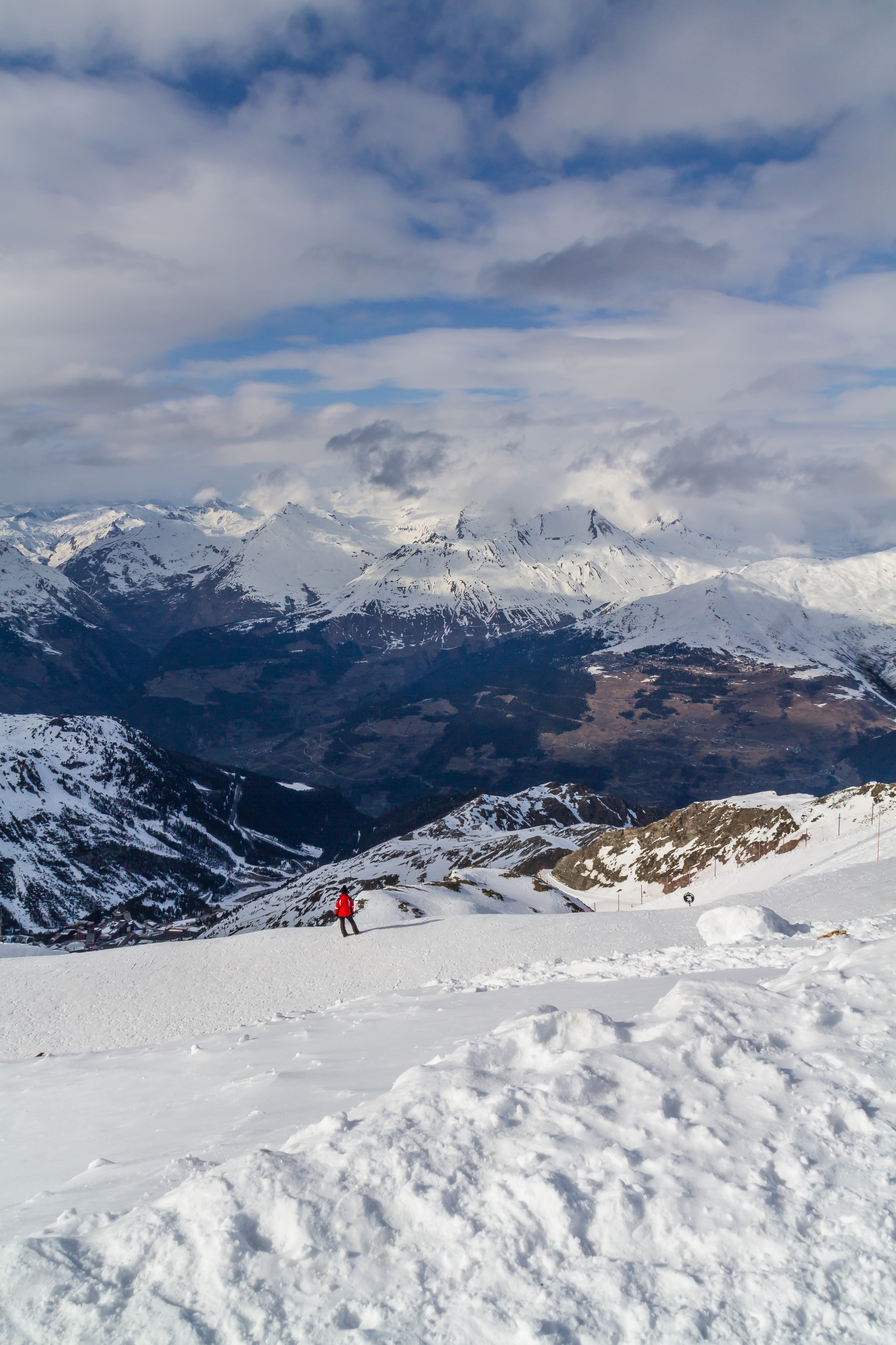
English: View from the summit of the Aiguile Rouge (Red Needle), in the Vanoise Massif...In the center right we can see the ski resort of La Rosire, in the other side of the valley...In the same side of the valley, on the left, we can see another ski resort, Arc 2000, from where this peak can be reached by cable-car. |
Date | |
Source | Own work |
Author | Mauricio Moura da Silva |
Camera location | 45° 33′ 06.48″ N, 6° 50′ 54.78″ E | View this and other nearby images on: OpenStreetMap | 45.551800; 6.848550 |
---|
Parc national de la Vanoise
Licensing[edit]
- You are free:
- to share – to copy, distribute and transmit the work
- to remix – to adapt the work
- Under the following conditions:
- attribution – You must give appropriate credit, provide a link to the license, and indicate if changes were made. You may do so in any reasonable manner, but not in any way that suggests the licensor endorses you or your use.
- share alike – If you remix, transform, or build upon the material, you must distribute your contributions under the same or compatible license as the original.
This image was uploaded as part of Wiki Loves Earth 2015.
aragonés | العربية | asturianu | azərbaycanca | беларуская (тарашкевіца) | български | বাংলা | brezhoneg | català | čeština | Cymraeg | Deutsch | Ελληνικά | English | español | eesti | euskara | فارسی | français | galego | עברית | hrvatski | հայերեն | Bahasa Indonesia | italiano | 日本語 | ქართული | 한국어 | latviešu | македонски | മലയാളം | मराठी | Bahasa Melayu | norsk bokmål | नेपाली | Nederlands | norsk | polski | português | português do Brasil | русский | sicilianu | shqip | slovenščina | српски / srpski | svenska | ไทย | Türkçe | українська | اردو | 中文 | 中文(台灣) | +/− |
File history
Click on a date/time to view the file as it appeared at that time.
Date/Time | Thumbnail | Dimensions | User | Comment | |
---|---|---|---|---|---|
current | 20:18, 12 May 2015 | 3,456 × 5,184 (9.21 MB) | Mauriciomoura (talk | contribs) | User created page with UploadWizard |
You cannot overwrite this file.
File usage on Commons
The following 2 pages use this file:
Metadata
This file contains additional information such as Exif metadata which may have been added by the digital camera, scanner, or software program used to create or digitize it. If the file has been modified from its original state, some details such as the timestamp may not fully reflect those of the original file. The timestamp is only as accurate as the clock in the camera, and it may be completely wrong.
Camera manufacturer | Canon |
---|---|
Camera model | Canon EOS M |
Author | Mauricio Moura |
Exposure time | 1/500 sec (0.002) |
F-number | f/14 |
ISO speed rating | 100 |
Date and time of data generation | 16:13, 24 March 2015 |
Lens focal length | 18 mm |
Latitude | 45° 33′ 6.48″ N |
Longitude | 6° 50′ 54.78″ E |
Altitude | 3,184.216 meters above sea level |
Short title | Aiguille Rouge |
City shown | Sainte-Foy-Tarentaise |
Copyright holder | © Mauricio Moura |
Image title | View from the summit of the Aiguile Rouge (Red Needle), in the Vanoise Massif...In the center right we can see the ski resort of La Rosire, in the other side of the valley...In the same side of the valley, on the left, we can see another ski resort, Arc 2000, from where this peak can be reached by cable-car. |
Online copyright statement | http://mauriciomoura.com |
Usage terms |
|
Orientation | Normal |
Horizontal resolution | 72 dpi |
Vertical resolution | 72 dpi |
Software used | Adobe Photoshop Lightroom 6.0 (Windows) |
File change date and time | 22:54, 11 May 2015 |
Exposure Program | Normal program |
Exif version | 2.3 |
Date and time of digitizing | 16:13, 24 March 2015 |
APEX shutter speed | 8.965784 |
APEX aperture | 7.61471 |
APEX exposure bias | −0.33333333333333 |
Maximum land aperture | 3.625 APEX (f/3.51) |
Metering mode | Pattern |
Flash | Flash did not fire, compulsory flash suppression |
DateTimeOriginal subseconds | 55 |
DateTimeDigitized subseconds | 55 |
Color space | sRGB |
Focal plane X resolution | 5,798.6577181208 |
Focal plane Y resolution | 5,788.9447236181 |
Focal plane resolution unit | inches |
Custom image processing | Normal process |
Exposure mode | Auto exposure |
White balance | Auto white balance |
Scene capture type | Standard |
Geodetic survey data used | WGS-84 |
GPS tag version | 0.0.2.2 |
IIM version | 4 |
Keywords |
|
Province or state shown | Rhône-Alpes |
Code for country shown | FR |
Country shown | France |
Serial number of camera | 042542304444 |
Lens used | 18-200mm |
Date metadata was last modified | 00:54, 12 May 2015 |
Unique ID of original document | 185254749E9EF4E4942D640A1D0057AC |
Copyright status | Copyrighted |
Contact information |
|
Structured data
Items portrayed in this file
depicts
some value
24 March 2015
45°33'6.48"N, 6°50'54.78"E
image/jpeg
2966dc8d67902d30b50e79d09e8de22c32670add
9,652,267 byte
5,184 pixel
3,456 pixel
- Files with coordinates missing SDC location of creation
- CC-BY-SA-3.0
- Self-published work
- Images from Wiki Loves Earth 2015
- Images from Wiki Loves Earth 2015 in France
- Images from Wiki Loves Earth missing SDC depicts
- Images from Wiki Loves Earth missing SDC location of creation
- Uploaded via Campaign:wle-fr
- France photographs taken on 2015-03-24
- Pages with maps