File:Aguada Fort Top View, North Goa.jpg
Original file (4,000 × 2,250 pixels, file size: 3.9 MB, MIME type: image/jpeg)
Captions
Summary[edit]
DescriptionAguada Fort Top View, North Goa.jpg |
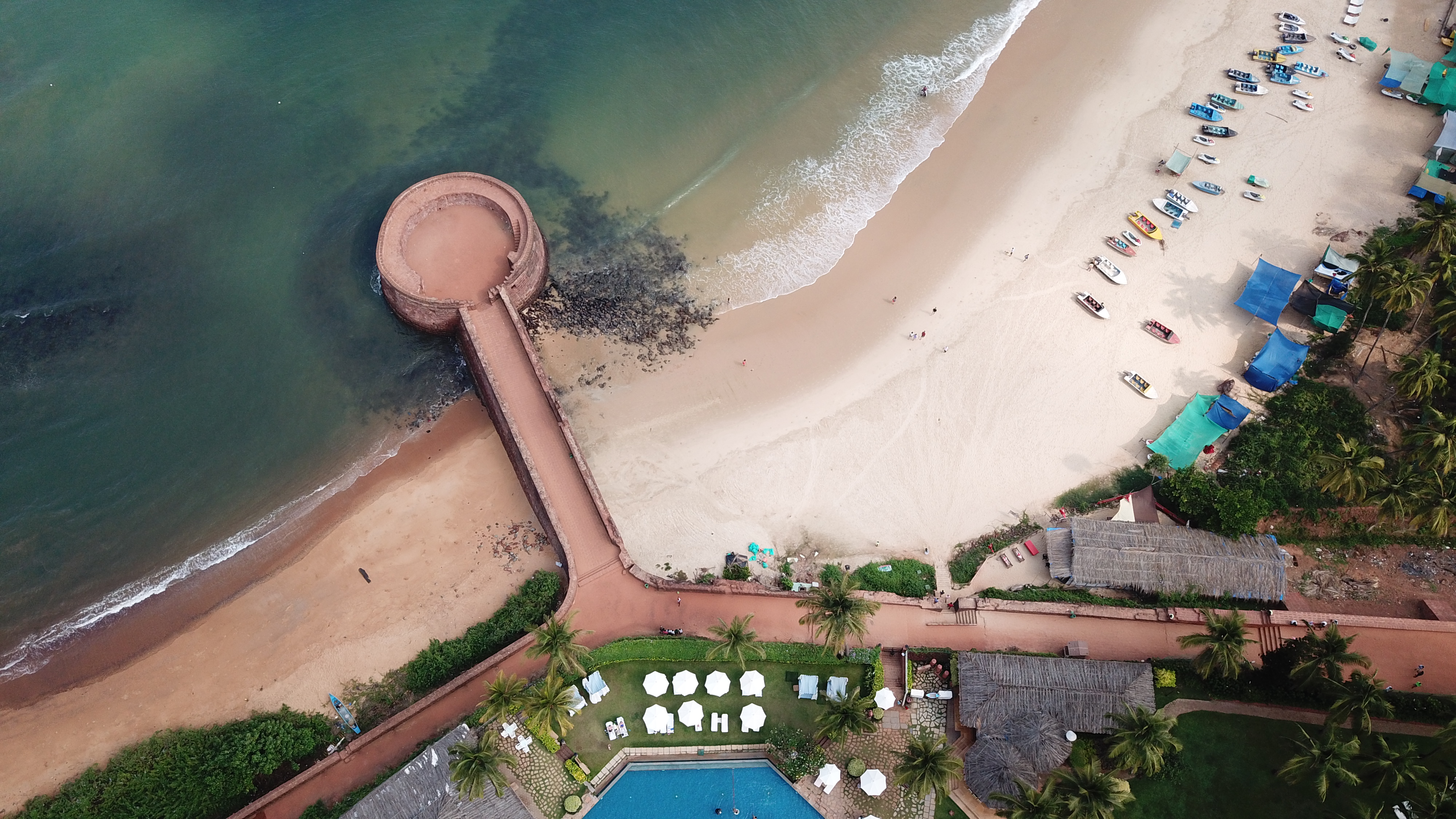
English: Aerial Photo of Aguada Fort Lower, North Goa
|
||
Date | |||
Source | Own work | ||
Author | Rupeshsarkar |
Camera location | 15° 29′ 52.04″ N, 73° 46′ 01.11″ E | View this and other nearby images on: OpenStreetMap | 15.497788; 73.766975 |
---|
This image was awarded with the 1st prize in the national contest of India in Wiki Loves Monuments 2019 Other languages:
العربية | беларуская (тарашкевіца) | বাংলা | Deutsch | English | British English | español | français | hrvatski | italiano | ქართული | македонски | norsk (bokmål) | norsk (nynorsk) | português do Brasil | русский | slovenščina | svenska | українська | +/− |
Licensing[edit]
- You are free:
- to share – to copy, distribute and transmit the work
- to remix – to adapt the work
- Under the following conditions:
- attribution – You must give appropriate credit, provide a link to the license, and indicate if changes were made. You may do so in any reasonable manner, but not in any way that suggests the licensor endorses you or your use.
- share alike – If you remix, transform, or build upon the material, you must distribute your contributions under the same or compatible license as the original.
This image was uploaded as part of Wiki Loves Monuments 2019.
Afrikaans ∙ Alemannisch ∙ azərbaycanca ∙ Bahasa Indonesia ∙ Bahasa Melayu ∙ Bikol Central ∙ bosanski ∙ brezhoneg ∙ català ∙ čeština ∙ Cymraeg ∙ dansk ∙ davvisámegiella ∙ Deutsch ∙ eesti ∙ English ∙ español ∙ Esperanto ∙ euskara ∙ français ∙ Frysk ∙ Gaeilge ∙ galego ∙ hrvatski ∙ Ido ∙ italiano ∙ latviešu ∙ Lëtzebuergesch ∙ Malagasy ∙ magyar ∙ Malti ∙ Nederlands ∙ norsk ∙ norsk nynorsk ∙ norsk bokmål ∙ polski ∙ português ∙ português do Brasil ∙ română ∙ shqip ∙ sicilianu ∙ slovenčina ∙ slovenščina ∙ suomi ∙ svenska ∙ Tagalog ∙ Türkçe ∙ Yorùbá ∙ Zazaki ∙ Ελληνικά ∙ беларуская ∙ беларуская (тарашкевіца) ∙ български ∙ кыргызча ∙ македонски ∙ русский ∙ српски / srpski ∙ українська ∙ ქართული ∙ հայերեն ∙ नेपाली ∙ हिन्दी ∙ বাংলা ∙ മലയാളം ∙ ไทย ∙ 한국어 ∙ +/− |
This image was selected as picture of the day on Bengali Wikipedia.
|
This image has been assessed using the Quality image guidelines and is considered a Quality image.
العربية ∙ جازايرية ∙ беларуская ∙ беларуская (тарашкевіца) ∙ български ∙ বাংলা ∙ català ∙ čeština ∙ Cymraeg ∙ Deutsch ∙ Schweizer Hochdeutsch ∙ Zazaki ∙ Ελληνικά ∙ English ∙ Esperanto ∙ español ∙ eesti ∙ euskara ∙ فارسی ∙ suomi ∙ français ∙ galego ∙ עברית ∙ हिन्दी ∙ hrvatski ∙ magyar ∙ հայերեն ∙ Bahasa Indonesia ∙ italiano ∙ 日本語 ∙ Jawa ∙ ქართული ∙ 한국어 ∙ kurdî ∙ Lëtzebuergesch ∙ lietuvių ∙ македонски ∙ മലയാളം ∙ मराठी ∙ Bahasa Melayu ∙ Nederlands ∙ Norfuk / Pitkern ∙ polski ∙ português ∙ português do Brasil ∙ rumantsch ∙ română ∙ русский ∙ sicilianu ∙ slovenčina ∙ slovenščina ∙ shqip ∙ српски / srpski ∙ svenska ∙ தமிழ் ∙ తెలుగు ∙ ไทย ∙ Tagalog ∙ Türkçe ∙ toki pona ∙ українська ∙ vèneto ∙ Tiếng Việt ∙ 中文 ∙ 中文(简体) ∙ 中文(繁體) ∙ +/− |
File history
Click on a date/time to view the file as it appeared at that time.
Date/Time | Thumbnail | Dimensions | User | Comment | |
---|---|---|---|---|---|
current | 14:36, 22 September 2019 | 4,000 × 2,250 (3.9 MB) | Rupeshsarkar (talk | contribs) | User created page with UploadWizard |
You cannot overwrite this file.
File usage on Commons
The following 12 pages use this file:
- Wiki Loves Monuments 2019 winners
- User talk:Rupeshsarkar
- Commons:Quality images/Technical/Perspective
- Commons:Quality images candidates/Archives January 05 2022
- Commons:Wiki Loves Monuments 2019 in India/Winners
- Commons:Wiki Loves Monuments 2019 in India/Winners/de
- Commons:Wiki Loves Monuments 2019 in India/Winners/en
- Commons:Wiki Loves Monuments 2019 in India/Winners/fr
- Commons:Wiki Loves Monuments in India/Goa/North Goa
- Commons:Wiki Loves Monuments in India/Monuments/National Importance/Goa
- File:Aguada Fort 4, North Goa.jpg (file redirect)
- Category:Aguada Fortress (Lower)
File usage on other wikis
The following other wikis use this file:
- Usage on bn.wikipedia.org
- Usage on da.wikipedia.org
- Usage on en.wikipedia.org
- Usage on meta.wikimedia.org
- Usage on ta.wikipedia.org
- Usage on www.wikidata.org
Metadata
This file contains additional information such as Exif metadata which may have been added by the digital camera, scanner, or software program used to create or digitize it. If the file has been modified from its original state, some details such as the timestamp may not fully reflect those of the original file. The timestamp is only as accurate as the clock in the camera, and it may be completely wrong.
Image title | DCIM\100MEDIA\DJI_0032.JPG |
---|---|
Camera manufacturer | DJI |
Camera model | FC220 |
Exposure time | 337/200,000 sec (0.001685) |
F-number | f/2.2 |
ISO speed rating | 100 |
Date and time of data generation | 09:41, 3 April 2018 |
Lens focal length | 4.73 mm |
Latitude | 15° 29′ 52.04″ N |
Longitude | 73° 46′ 1.11″ E |
Altitude | 124.097 meters above sea level |
Orientation | Normal |
Horizontal resolution | 72 dpi |
Vertical resolution | 72 dpi |
Software used | v02.10.519 |
File change date and time | 09:41, 3 April 2018 |
Y and C positioning | Centered |
Exposure Program | Normal program |
Exif version | 2.3 |
Date and time of digitizing | 09:41, 3 April 2018 |
Meaning of each component |
|
Image compression mode | 3.3683137777778 |
APEX aperture | 2.27 |
APEX exposure bias | 0 |
Maximum land aperture | 2.27 APEX (f/2.2) |
Subject distance | 0 meters |
Metering mode | Center weighted average |
Light source | Unknown |
Flash | Flash did not fire, No flash function |
Supported Flashpix version | 0.1 |
Color space | sRGB |
File source | Digital still camera |
Scene type | A directly photographed image |
Custom image processing | Normal process |
Exposure mode | Auto exposure |
White balance | Auto white balance |
Focal length in 35 mm film | 26 mm |
Scene capture type | Standard |
Scene control | None |
Contrast | Normal |
Saturation | Normal |
Sharpness | Normal |
Subject distance range | Unknown |
GPS tag version | 0.0.3.2 |
Structured data
Items portrayed in this file
depicts
15°29'52.037"N, 73°46'1.110"E
3 April 2018
image/jpeg
f9bc4b9c35fb3afabb9cbe870447293b0124be8c
4,092,630 byte
2,250 pixel
4,000 pixel
- ASI monuments with known IDs
- Winners of Wiki Loves Monuments 2019 in India
- Nominated pictures for Wiki Loves Monuments International
- CC-BY-SA-4.0
- Self-published work
- Images from Wiki Loves Monuments 2019
- Images from Wiki Loves Monuments 2019 in India
- Files from competitions organized by West Bengal Wikimedians User Group
- Featured pictures on Wikipedia, Bengali
- Images from WLM 2019 India under review by Montage tool
- Uploaded via Campaign:wlm-in
- India photographs taken on 2018-04-03
- Quality images from Wiki Loves Monuments India 2019
- Quality images
- Pages with maps