File:Agriculture in Saudi Arabia ESA344584.jpg
Jump to navigation
Jump to search

Size of this preview: 800 × 491 pixels. Other resolutions: 320 × 197 pixels | 640 × 393 pixels | 1,024 × 629 pixels | 1,280 × 786 pixels | 2,560 × 1,572 pixels | 3,913 × 2,403 pixels.
Original file (3,913 × 2,403 pixels, file size: 5.59 MB, MIME type: image/jpeg)
Captions
Captions
Add a one-line explanation of what this file represents
Summary
[edit]
| Description |
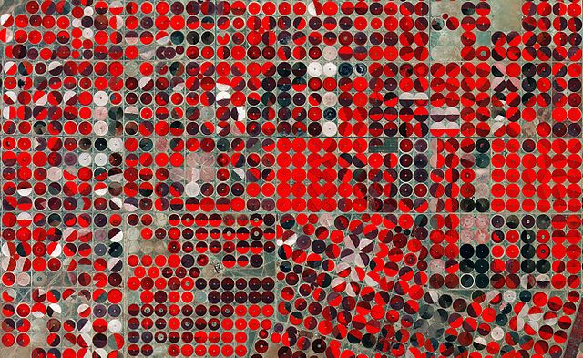
English: This false-colour image from the Sentinel-2A satellite shows agricultural structures near Tubarjal, Saudi Arabia. Circles come from a central-pivot irrigation system, where the long water pipe rotates around a well at the centre. |
| Date | |
| Source | http://www.esa.int/spaceinimages/Images/2015/07/Agriculture_in_Saudi_Arabia |
| Author | European Space Agency |
| Permission (Reusing this file) |
Copernicus Sentinel data (2015)/ESA,CC BY-SA 3.0 IGO |
| Title | Agriculture in Saudi Arabia |
| Location | Saudi Arabia |
| Keywords | Agriculture |
| Mission | Sentinel-2 |
| Activity | Observing the Earth |
Licensing
[edit]
This file is licensed under the Creative Commons Attribution-ShareAlike 3.0 IGO license.
- You are free:
- to share – to copy, distribute and transmit the work
- to remix – to adapt the work
- Under the following conditions:
- attribution – You must give appropriate credit, provide a link to the license, and indicate if changes were made. You may do so in any reasonable manner, but not in any way that suggests the licensor endorses you or your use.
- share alike – If you remix, transform, or build upon the material, you must distribute your contributions under the same or compatible license as the original.
File history
Click on a date/time to view the file as it appeared at that time.
| Date/Time | Thumbnail | Dimensions | User | Comment | |
|---|---|---|---|---|---|
| current | 16:28, 6 May 2017 | | 3,913 × 2,403 (5.59 MB) | Fæ (talk | contribs) | == {{int:filedesc}} == {{information | description = {{en|1=This false-colour image from the Sentinel-2A satellite shows agricultural structures near Tubarjal, Saudi Arabia. Circles come from a central-pivot irrigation system, where the long water pipe... |
You cannot overwrite this file.
File usage on Commons
There are no pages that use this file.
File usage on other wikis
The following other wikis use this file:
- Usage on bg.wikipedia.org
- Usage on uk.wikipedia.org
- Usage on www.wikidata.org