File:Agnes-tornado-track.jpg
Jump to navigation
Jump to search
No higher resolution available.
Agnes-tornado-track.jpg (650 × 525 pixels, file size: 95 KB, MIME type: image/jpeg)
Captions
Captions
Add a one-line explanation of what this file represents
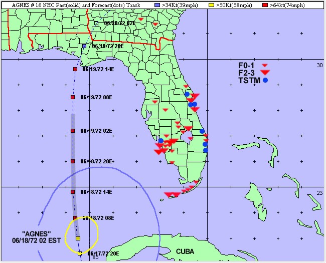
| Description | Plot of tornadoes by F-scale and severe thunderstorms of the Agnes outbreak. Agnes is shown at 0200 EDT 18 June 1972 with wind field radii just before the first tornado report in the Keys. Six-hourly positions are shown on the track. The heavy shaded part of the track marks the period when Agnes's rainbands were producing tornadoes. | |||
| Date | ||||
| Source | http://www.srh.weather.gov/mlb/agnes30.html | |||
| Author | Bartlett C. Hagemeyer and Scott M. Spratt- National Weather Service, Melbourne, Florida | |||
| Permission (Reusing this file) |
|
File history
Click on a date/time to view the file as it appeared at that time.
| Date/Time | Thumbnail | Dimensions | User | Comment | |
|---|---|---|---|---|---|
| current | 20:36, 5 April 2007 | | 650 × 525 (95 KB) | Hurricanehink (talk | contribs) | {{Information |Description=Plot of tornadoes by F-scale and severe thunderstorms of the Agnes outbreak. Agnes is shown at 0200 EDT 18 June 1972 with wind field radii just before the first tornado report in the Keys. Six-hourly positions are shown on the t |
You cannot overwrite this file.
File usage on Commons
There are no pages that use this file.
File usage on other wikis
The following other wikis use this file:
- Usage on en.wikipedia.org