File:Agglomeration-parisienne.png
Jump to navigation
Jump to search
Size of this preview: 593 × 600 pixels. Other resolutions: 237 × 240 pixels | 475 × 480 pixels.
Original file (800 × 809 pixels, file size: 48 KB, MIME type: image/png)
Captions
Captions
Add a one-line explanation of what this file represents
Summary[edit]
| Description |
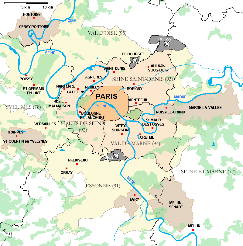
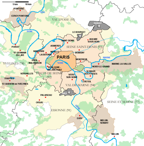
Description : Carte de l'agglomération de Paris
|
| Date | 24 September 2006 (original upload date) |
| Source | Own work |
| Author | Pline |
Licensing[edit]
I, the copyright holder of this work, hereby publish it under the following licenses:

|
Permission is granted to copy, distribute and/or modify this document under the terms of the GNU Free Documentation License, Version 1.2 or any later version published by the Free Software Foundation; with no Invariant Sections, no Front-Cover Texts, and no Back-Cover Texts. A copy of the license is included in the section entitled GNU Free Documentation License. |
| This file is licensed under the Creative Commons Attribution-Share Alike 3.0 Unported license. | ||
| ||
| This licensing tag was added to this file as part of the GFDL licensing update. |
This file is licensed under the Creative Commons Attribution-Share Alike 2.5 Generic, 2.0 Generic and 1.0 Generic license.
- You are free:
- to share – to copy, distribute and transmit the work
- to remix – to adapt the work
- Under the following conditions:
- attribution – You must give appropriate credit, provide a link to the license, and indicate if changes were made. You may do so in any reasonable manner, but not in any way that suggests the licensor endorses you or your use.
- share alike – If you remix, transform, or build upon the material, you must distribute your contributions under the same or compatible license as the original.
You may select the license of your choice.
File history
Click on a date/time to view the file as it appeared at that time.
| Date/Time | Thumbnail | Dimensions | User | Comment | |
|---|---|---|---|---|---|
| current | 06:37, 25 September 2006 | | 800 × 809 (48 KB) | Pline (talk | contribs) | |
| 20:18, 24 September 2006 |  | 800 × 809 (48 KB) | Pline (talk | contribs) | ||
| 19:21, 24 September 2006 |  | 800 × 809 (47 KB) | Pline (talk | contribs) | *Description : Carte de l'agglomération de Paris *Place : Paris, France *Date : Septembre 2006 *Author : Réalisation Pline Category:Maps of Paris |
You cannot overwrite this file.
File usage on Commons
There are no pages that use this file.
File usage on other wikis
The following other wikis use this file:
- Usage on bg.wikipedia.org
- Usage on da.wikipedia.org
- Usage on de.wikipedia.org
- Usage on fa.wikipedia.org
- Usage on fr.wikipedia.org
- Démographie de l'Île-de-France
- Modèle:Sommaire arrondissements de Paris
- Modèle:Infobox Voie de Paris
- Démographie de Paris
- Modèle:Géolocalisation/Paris
- Modèle:Carte/Paris
- Utilisateur:Pline/Cartes et schémas
- Modèle:Infobox Voie de Paris/Documentation
- Modèle:Chronologie de Paris
- Modèle:Infobox Porte de Paris
- Modèle:Infobox Porte de Paris/Documentation
- Modèle:Pays & territoires de naissance des Franciliens
- Modèle:Country data Paris
- Modèle:Tableau des superficies successives de Paris
- Modèle:Agglomération parisienne
- Modèle:Évolution de la population en Île-de-France
- Modèle:Courbe d'évolution de la population en Île-de-France
- Modèle:Évolution de la population de l'Île-de-France par département
- Modèle:Modèles liés Paris
- Modèle:Tableau Démographie Paris
- Modèle:Histogramme population Paris
- Modèle:Infobox Voie de Paris/Bac à sable
- Usage on la.wikipedia.org
- Usage on vi.wikipedia.org