File:African continent-uk.svg
Jump to navigation
Jump to search

Size of this PNG preview of this SVG file: 635 × 600 pixels. Other resolutions: 254 × 240 pixels | 508 × 480 pixels | 813 × 768 pixels | 1,084 × 1,024 pixels | 2,169 × 2,048 pixels | 1,525 × 1,440 pixels.
Original file (SVG file, nominally 1,525 × 1,440 pixels, file size: 736 KB)
Captions
Captions
Add a one-line explanation of what this file represents
Summary[edit]
| Description |
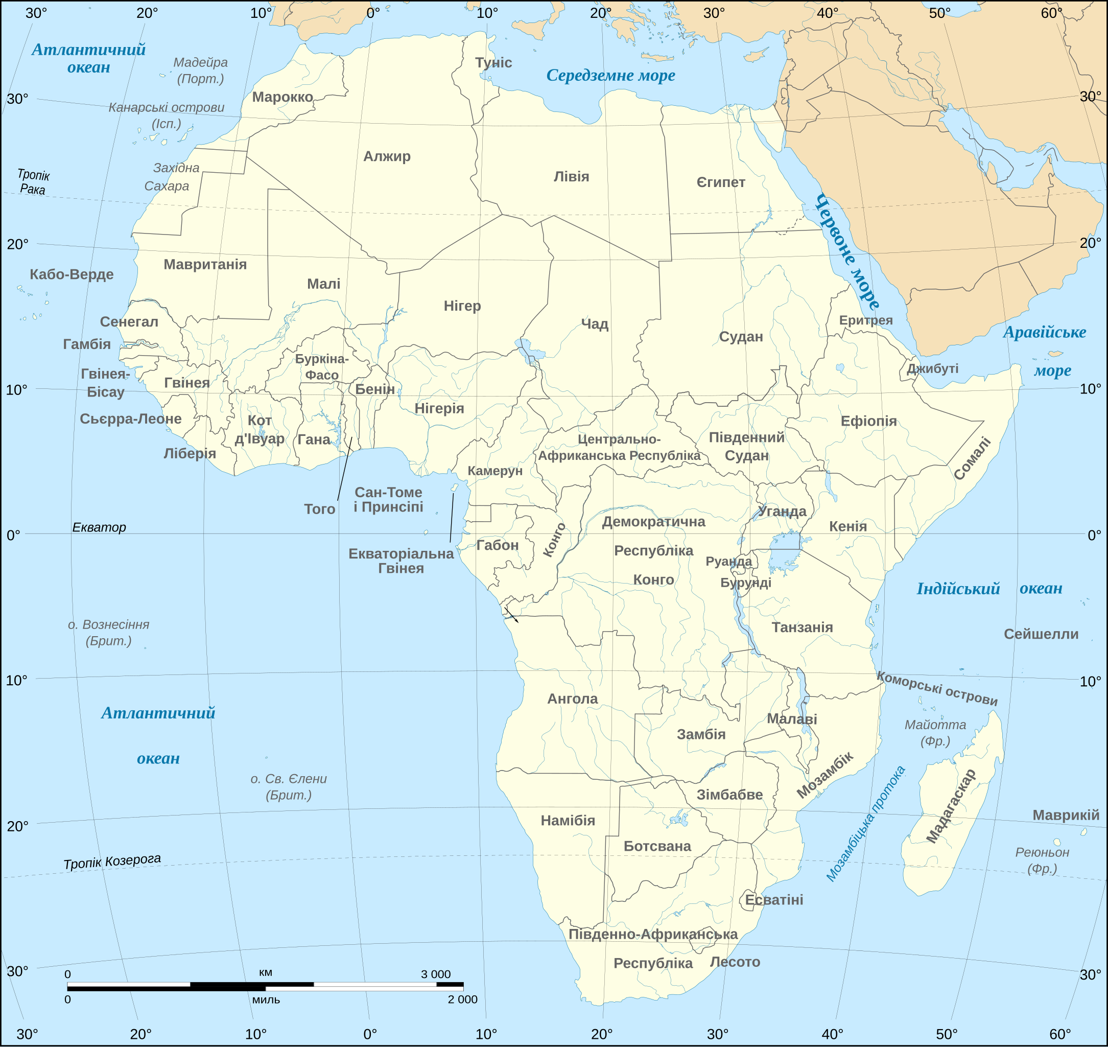
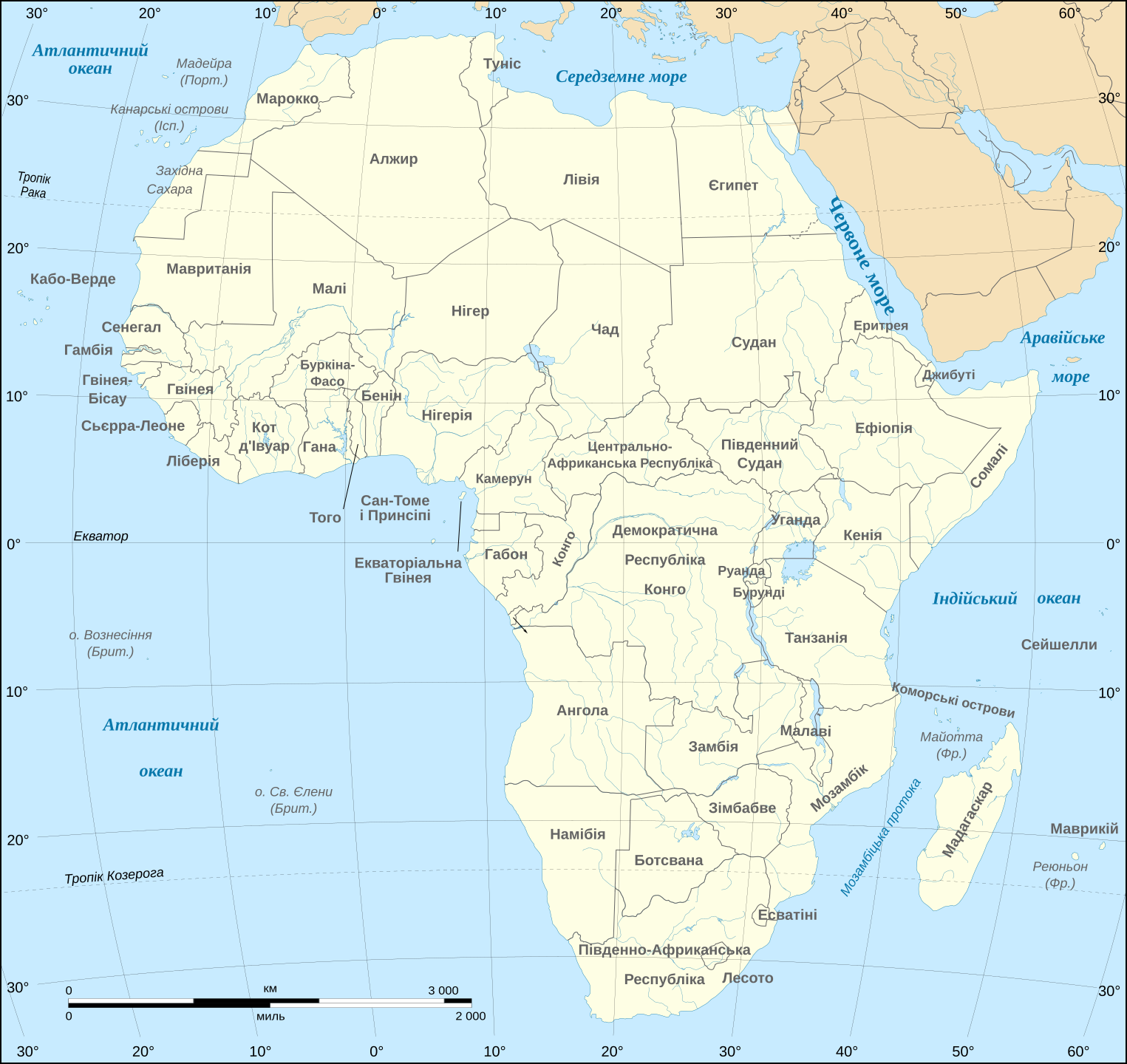
Українська: Політична карта Африки
Мірило: 1:15 000 000 |
||
| Date | (UTC), updated 2011-07 | ||
| Source | African continent-en.svg | ||
| Author |
|
||
| Other versions |
[]
|
||
| SVG development |
|


Licensing[edit]
I, the copyright holder of this work, hereby publish it under the following license:
This file is licensed under the Creative Commons Attribution-Share Alike 2.5 Generic, 2.0 Generic and 1.0 Generic license.
- You are free:
- to share – to copy, distribute and transmit the work
- to remix – to adapt the work
- Under the following conditions:
- attribution – You must give appropriate credit, provide a link to the license, and indicate if changes were made. You may do so in any reasonable manner, but not in any way that suggests the licensor endorses you or your use.
- share alike – If you remix, transform, or build upon the material, you must distribute your contributions under the same or compatible license as the original.
Original upload log[edit]
This image is a derivative work of the following images:
- File:African_continent-en.svg licensed with Cc-by-sa-2.5,2.0,1.0
- 2009-01-10T20:16:53Z Sting 1525x1440 (764671 Bytes) Correction Sao Tome
- 2008-12-06T08:37:49Z Bobarino 1525x1440 (767777 Bytes) {{Information |Description={{en|Map of the [[:Category:Maps of Africa|African continent]].}} {{fr|Carte vierge du [[:Category:Maps of Africa|continent africain]].}} Lambert azimutal equal-area projection, WGS84 datum, standar
Uploaded with derivativeFX
File history
Click on a date/time to view the file as it appeared at that time.
| Date/Time | Thumbnail | Dimensions | User | Comment | |
|---|---|---|---|---|---|
| current | 18:36, 6 December 2020 | | 1,525 × 1,440 (736 KB) | Sting (talk | contribs) | Swatziland => eSwatini |
| 20:32, 20 July 2011 |  | 1,525 × 1,440 (736 KB) | Sting (talk | contribs) | Sudan/South Sudan 2011-07 border update | |
| 07:06, 4 November 2010 |  | 1,525 × 1,440 (742 KB) | Dim Grits (talk | contribs) | Corrected | |
| 06:59, 4 November 2010 |  | 1,525 × 1,440 (744 KB) | Dim Grits (talk | contribs) | {{Information |Description={{uk|Політична карта Африки}}<br/> Мірило: 1:15 000 000 |Source=*File:African_continent-en.svg |Date=2010-11-04 06:58 (UTC) |Author=*[[:File:African_continent-en.svg|] |
You cannot overwrite this file.
File usage on Commons
The following 29 pages use this file:
- Commons:Translation possible/En savoir plus
- File:Africa map blank.svg
- File:Africa map no countries.svg
- File:African continent-br.svg
- File:African continent-ca.svg
- File:African continent-cs.svg
- File:African continent-da.svg
- File:African continent-de.png
- File:African continent-de.svg
- File:African continent-en.svg
- File:African continent-es.svg
- File:African continent-fr.svg
- File:African continent-it.svg
- File:African continent-ka.svg
- File:African continent-ku.svg
- File:African continent-la.svg
- File:African continent-mk.svg
- File:African continent-nb.svg
- File:African continent-pl.png
- File:African continent-pl.svg
- File:African continent-pt.svg
- File:African continent-ru.svg
- File:African continent-uk.svg
- File:African continent-ur2.svg
- File:African continent-繁體中文.png
- File:African continent-繁體中文.svg
- File:African continent sr.svg
- File:Afrik kárttá smn.svg
- Template:Other versions/African continent
File usage on other wikis
The following other wikis use this file:
- Usage on uk.wikipedia.org