File:African continent-it.svg
Jump to navigation
Jump to search

Size of this PNG preview of this SVG file: 635 × 600 pixels. Other resolutions: 254 × 240 pixels | 508 × 480 pixels | 813 × 768 pixels | 1,084 × 1,024 pixels | 2,169 × 2,048 pixels | 1,525 × 1,440 pixels.
Original file (SVG file, nominally 1,525 × 1,440 pixels, file size: 741 KB)
Captions
Captions
Add a one-line explanation of what this file represents
Summary[edit]
| Description |
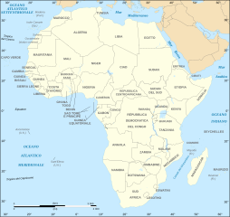
English: Political map of the African continent with Italian caption
Italiano: Cartina politica dell'Africa in italiano
Lambert azimutal equal-area projection, WGS84 datum, standard meridian: 15°E, standard parallel: 0° |
||
| Date | December 2007 (June 2008 for the new version), updated 2011-07 | ||
| Source |
French version
|
||
| Author |
English: Kanchelskis based on Eric Gaba (Sting)
Italiano: Kanchelskis dall'originale di Eric Gaba (Sting) |
||
| Permission (Reusing this file) |
This file is licensed under the Creative Commons Attribution-Share Alike 3.0 Unported license.
|
||
| Other versions |
[]
|


File history
Click on a date/time to view the file as it appeared at that time.
| Date/Time | Thumbnail | Dimensions | User | Comment | |
|---|---|---|---|---|---|
| current | 18:28, 6 December 2020 | | 1,525 × 1,440 (741 KB) | Sting (talk | contribs) | Swatziland => eSwatini |
| 20:14, 20 July 2011 |  | 1,525 × 1,440 (741 KB) | Sting (talk | contribs) | Sudan/South Sudan 2011-07 border update | |
| 20:30, 10 January 2009 |  | 1,525 × 1,440 (747 KB) | Sting (talk | contribs) | Correction Sao Tome | |
| 21:04, 27 June 2008 |  | 1,525 × 1,440 (751 KB) | Sting (talk | contribs) | Completely new drawing with known projection ; new colors ; additional forgotten translations | |
| 23:08, 23 January 2008 |  | 1,390 × 1,295 (609 KB) | F l a n k e r (talk | contribs) | Zambie -> Zambia + Mozambique -> Mozambico | |
| 15:03, 27 December 2007 |  | 1,390 × 1,295 (610 KB) | Kanchelskis (talk | contribs) | == Summary == {{Information |Description=Political map of the African continent with Italian caption |Source=French version |Date= December 2007 |Author= Kanchelskis based on Eric Gaba (Sting) |Permission=GFDL o |
You cannot overwrite this file.
File usage on Commons
The following 30 pages use this file:
- User:Magog the Ogre/Multilingual legend/2020 December 1-10
- Commons:Translation possible/En savoir plus
- File:Africa map blank.svg
- File:Africa map no countries.svg
- File:African continent-br.svg
- File:African continent-ca.svg
- File:African continent-cs.svg
- File:African continent-da.svg
- File:African continent-de.png
- File:African continent-de.svg
- File:African continent-en.svg
- File:African continent-es.svg
- File:African continent-fr.svg
- File:African continent-it.svg
- File:African continent-ka.svg
- File:African continent-ku.svg
- File:African continent-la.svg
- File:African continent-mk.svg
- File:African continent-nb.svg
- File:African continent-pl.png
- File:African continent-pl.svg
- File:African continent-pt.svg
- File:African continent-ru.svg
- File:African continent-uk.svg
- File:African continent-ur2.svg
- File:African continent-繁體中文.png
- File:African continent-繁體中文.svg
- File:African continent sr.svg
- File:Afrik kárttá smn.svg
- Template:Other versions/African continent
File usage on other wikis
The following other wikis use this file:
- Usage on it.wikipedia.org
- Usage on it.wiktionary.org
- Usage on ko.wikipedia.org
- Usage on mk.wikipedia.org
- Usage on roa-tara.wikipedia.org
- Usage on vec.wikipedia.org