File:African continent-de.svg
Jump to navigation
Jump to search

Size of this PNG preview of this SVG file: 635 × 600 pixels. Other resolutions: 254 × 240 pixels | 508 × 480 pixels | 813 × 768 pixels | 1,084 × 1,024 pixels | 2,169 × 2,048 pixels | 1,525 × 1,440 pixels.
Original file (SVG file, nominally 1,525 × 1,440 pixels, file size: 749 KB)
Captions
Captions
Add a one-line explanation of what this file represents
Summary[edit]
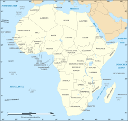
| Description |
Deutsch: Politische Karte von Afrika als in 07-2011 (deutschsprachig)
English: Political map of the African Continent as in 2011-07 with German caption
Français : Carte politique du continent africain tel qu'en 07/2011 avec légende en allemand
Norsk bokmål: Politisk kart over Afrika på tysk.
Lambert azimutal equal-area projection, WGS84 datum, standard meridian: 15°E, standard parallel: 0° |
| Date | 16 March 2008, updated 2011-07 |
| Source |
African continent-fr.svg
|
| Author | Eric Gaba, Jörg Schwerdtfeger |
| Other versions |
[]
|
| SVG development |


Licensing[edit]

|
Permission is granted to copy, distribute and/or modify this document under the terms of the GNU Free Documentation License, Version 1.2 or any later version published by the Free Software Foundation; with no Invariant Sections, no Front-Cover Texts, and no Back-Cover Texts. A copy of the license is included in the section entitled GNU Free Documentation License. |
| This file is licensed under the Creative Commons Attribution-Share Alike 3.0 Unported license. | ||
| ||
| This licensing tag was added to this file as part of the GFDL licensing update. |
File history
Click on a date/time to view the file as it appeared at that time.
| Date/Time | Thumbnail | Dimensions | User | Comment | |
|---|---|---|---|---|---|
| current | 18:20, 6 December 2020 | | 1,525 × 1,440 (749 KB) | Sting (talk | contribs) | Swatziland => eSwatini |
| 11:38, 4 October 2012 |  | 1,525 × 1,440 (750 KB) | Svolks (talk | contribs) | SÃO TOMÈ --> SÃO TOMÉ | |
| 20:08, 14 July 2011 |  | 1,525 × 1,440 (750 KB) | Sting (talk | contribs) | Sudan/South Sudan 2011-07 border update | |
| 20:07, 10 January 2009 |  | 1,525 × 1,440 (745 KB) | Sting (talk | contribs) | Correction Sao Tome | |
| 01:51, 27 June 2008 |  | 1,525 × 1,440 (749 KB) | Sting (talk | contribs) | Completely new drawing with known projection ; new colors | |
| 08:10, 16 March 2008 |  | 1,390 × 1,295 (611 KB) | Schwerdtfeger (talk | contribs) | ||
| 07:42, 16 March 2008 |  | 1,390 × 1,295 (602 KB) | Schwerdtfeger (talk | contribs) | {{Information |Description= {{de|Politische Karte von Afrika (deutschsprachig)}} {{en|Political map of the African Continent with German caption}} {{fr|Carte politique du continent africain avec légende en al |
You cannot overwrite this file.
File usage on Commons
The following 31 pages use this file:
- User:Magog the Ogre/Multilingual legend/2020 December 1-10
- Commons:Copyright tags/Africa/de
- Commons:Translation possible/En savoir plus
- File:Africa map blank.svg
- File:Africa map no countries.svg
- File:African continent-br.svg
- File:African continent-ca.svg
- File:African continent-cs.svg
- File:African continent-da.svg
- File:African continent-de.png
- File:African continent-de.svg
- File:African continent-en.svg
- File:African continent-es.svg
- File:African continent-fr.svg
- File:African continent-it.svg
- File:African continent-ka.svg
- File:African continent-ku.svg
- File:African continent-la.svg
- File:African continent-mk.svg
- File:African continent-nb.svg
- File:African continent-pl.png
- File:African continent-pl.svg
- File:African continent-pt.svg
- File:African continent-ru.svg
- File:African continent-uk.svg
- File:African continent-ur2.svg
- File:African continent-繁體中文.png
- File:African continent-繁體中文.svg
- File:African continent sr.svg
- File:Afrik kárttá smn.svg
- Template:Other versions/African continent
File usage on other wikis
The following other wikis use this file:
- Usage on de.wikiversity.org
- Usage on es.wikibooks.org
- Usage on ko.wikipedia.org
- Usage on nl.wiktionary.org