File:African continent-cs.svg
Jump to navigation
Jump to search

Size of this PNG preview of this SVG file: 635 × 600 pixels. Other resolutions: 254 × 240 pixels | 508 × 480 pixels | 813 × 768 pixels | 1,084 × 1,024 pixels | 2,169 × 2,048 pixels | 1,525 × 1,440 pixels.
Original file (SVG file, nominally 1,525 × 1,440 pixels, file size: 674 KB)
Captions
Captions
Add a one-line explanation of what this file represents
| Description |
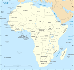
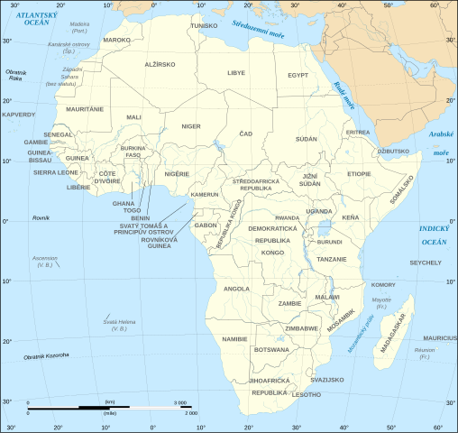
English: Political map of the African continent with Czech caption. Français : Carte politique du continent africain avec légende en tchèque. Lambert azimutal equal-area projection, WGS84 datum, standard meridian: 15°E, standard parallel: 0°Scale: 1:15,000,000 (accuracy: 3,75 km) Čeština: Politická mapa Afrického kontinentu |
| Date | (UTC), updated 2011-07 |
| Source | |
| Author |
|
| Other versions |
[]
|


| This is a retouched picture, which means that it has been digitally altered from its original version. The original can be viewed here: African continent-fr.svg:
|
I, the copyright holder of this work, hereby publish it under the following licenses:
This file is licensed under the Creative Commons Attribution-Share Alike 2.5 Generic, 2.0 Generic and 1.0 Generic license.
- You are free:
- to share – to copy, distribute and transmit the work
- to remix – to adapt the work
- Under the following conditions:
- attribution – You must give appropriate credit, provide a link to the license, and indicate if changes were made. You may do so in any reasonable manner, but not in any way that suggests the licensor endorses you or your use.
- share alike – If you remix, transform, or build upon the material, you must distribute your contributions under the same or compatible license as the original.

|
Permission is granted to copy, distribute and/or modify this document under the terms of the GNU Free Documentation License, Version 1.2 or any later version published by the Free Software Foundation; with no Invariant Sections, no Front-Cover Texts, and no Back-Cover Texts. A copy of the license is included in the section entitled GNU Free Documentation License. |
| This file is licensed under the Creative Commons Attribution-Share Alike 3.0 Unported license. | ||
| ||
| This licensing tag was added to this file as part of the GFDL licensing update. |
You may select the license of your choice.
Original upload log[edit]
This image is a derivative work of the following images:
- Image:African_continent-fr.svg licensed with Cc-by-sa-2.5,2.0,1.0, GFDL
- 2008-06-27T21:24:01Z Sting 1525x1440 (768579 Bytes) "Rép. du Congo" name correction
- 2008-06-27T01:46:54Z Sting 1525x1440 (768455 Bytes) One name correction
- 2008-06-26T23:37:59Z Sting 1525x1440 (768465 Bytes) Completely new drawing with known projection ; new colors
- 2006-05-31T22:56:10Z Sting 1390x1295 (626331 Bytes) {{Information |Description=Political map of the [[:Category:Maps of Africa|African continent]] with French caption |Source=Several bitmap-type maps |Date= May 2006 |Author= Eric Gaba ([[User:Sting|Sting]]) |Permission=GFDL or
Uploaded with derivativeFX
File history
Click on a date/time to view the file as it appeared at that time.
| Date/Time | Thumbnail | Dimensions | User | Comment | |
|---|---|---|---|---|---|
| current | 19:27, 8 December 2023 | | 1,525 × 1,440 (674 KB) | Takovej normální týpek (talk | contribs) | Reverted to version as of 19:10, 20 July 2011 (UTC) |
| 18:17, 6 December 2020 |  | 1,525 × 1,440 (674 KB) | Sting (talk | contribs) | Swatziland => eSwatini | |
| 19:10, 20 July 2011 |  | 1,525 × 1,440 (674 KB) | Sting (talk | contribs) | Sudan/South Sudan 2011-07 border update | |
| 17:24, 20 September 2008 |  | 1,525 × 1,440 (746 KB) | Podzemnik (talk | contribs) | {{Information |Description= |Source= |Date= |Author= |Permission= |other_versions= }} | |
| 17:16, 20 September 2008 |  | 1,525 × 1,440 (746 KB) | Podzemnik (talk | contribs) | {{Information |Description={{en|Political map of the African continent with French caption.}} {{fr|Carte politique du continent africain avec légende en français.}} Lambert azimutal equal-area pr |
You cannot overwrite this file.
File usage on Commons
The following 31 pages use this file:
- User:Magog the Ogre/Multilingual legend/2020 December 1-10
- User:Magog the Ogre/Multilingual legend/2023 December 5-8
- Commons:Translation possible/En savoir plus
- File:Africa map blank.svg
- File:Africa map no countries.svg
- File:African continent-br.svg
- File:African continent-ca.svg
- File:African continent-cs.svg
- File:African continent-da.svg
- File:African continent-de.png
- File:African continent-de.svg
- File:African continent-en.svg
- File:African continent-es.svg
- File:African continent-fr.svg
- File:African continent-it.svg
- File:African continent-ka.svg
- File:African continent-ku.svg
- File:African continent-la.svg
- File:African continent-mk.svg
- File:African continent-nb.svg
- File:African continent-pl.png
- File:African continent-pl.svg
- File:African continent-pt.svg
- File:African continent-ru.svg
- File:African continent-uk.svg
- File:African continent-ur2.svg
- File:African continent-繁體中文.png
- File:African continent-繁體中文.svg
- File:African continent sr.svg
- File:Afrik kárttá smn.svg
- Template:Other versions/African continent
File usage on other wikis
The following other wikis use this file:
- Usage on cs.wikipedia.org