File:Africa-countries-western.svg
Jump to navigation
Jump to search

Size of this PNG preview of this SVG file: 384 × 420 pixels. Other resolutions: 219 × 240 pixels | 439 × 480 pixels | 702 × 768 pixels | 936 × 1,024 pixels | 1,872 × 2,048 pixels.
Original file (SVG file, nominally 384 × 420 pixels, file size: 26 KB)
Captions
Captions
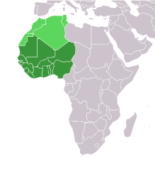
Map of West Africa
Summary[edit]
| Description |
English: Map with the countries of West Africa highlighted:
|
| Date | |
| Source |
This file was derived from: |
| Author | ReneeWrites |
| Other versions | |
| SVG development | This locator map was created with Adobe Illustrator. |


Licensing[edit]
This file is licensed under the Creative Commons Attribution 4.0 International license.
- You are free:
- to share – to copy, distribute and transmit the work
- to remix – to adapt the work
- Under the following conditions:
- attribution – You must give appropriate credit, provide a link to the license, and indicate if changes were made. You may do so in any reasonable manner, but not in any way that suggests the licensor endorses you or your use.
File history
Click on a date/time to view the file as it appeared at that time.
| Date/Time | Thumbnail | Dimensions | User | Comment | |
|---|---|---|---|---|---|
| current | 18:20, 12 December 2023 | | 384 × 420 (26 KB) | ReneeWrites (talk | contribs) | Uploaded a work by ReneeWrites from {{derived from|Africa-countries-blank.svg}} with UploadWizard |
You cannot overwrite this file.
File usage on Commons
The following 10 pages use this file:
- West Africa
- File:Africa-countries-blank.svg
- File:Africa-countries-central.svg
- File:Africa-countries-eastern.svg
- File:Africa-countries-northeast.svg
- File:Africa-countries-northern.svg
- File:Africa-countries-southern.svg
- File:Africa-countries-western.png
- File:Africa-countries-western.svg
- File:LocationWesternAfrica.png
File usage on other wikis
The following other wikis use this file:
- Usage on am.wikipedia.org
- ኢትዮጵያ
- አፍሪቃ
- ሱዳን
- ኬንያ
- ናይጄሪያ
- ግብፅ
- መለጠፊያ:በአፍሪካ ውስጥ የሚገኙ አገሮች
- አንጎላ
- ማላዊ
- ሊቢያ
- ናሚቢያ
- ኤርትራ
- ላይቤሪያ
- አልጄሪያ
- ኤስዋቲኒ
- ካሜሩን
- ሞዛምቢክ
- ካቦ ቨርዴ
- ታንዛኒያ
- ቡርኪና ፋሶ
- ሞሮኮ
- ቻድ
- ደቡብ አፍሪካ
- ሞሪታኒያ
- ምዕራባዊ ሣህራ
- ዩጋንዳ
- ሴኔጋል
- የመካከለኛው አፍሪካ ሪፐብሊክ
- ቦትስዋና
- ጋና
- ዛምቢያ
- ጋቦን
- ዚምባብዌ
- ማዳጋስካር
- ኮንጎ ዲሞክራሲያዊ ሪፐብሊክ
- ኮንጎ ሪፐብሊክ
- ማሊ
- ሩዋንዳ
- ቤኒን
- ጅቡቲ
- ጊኔ-ቢሳው
- ሶማሊያ
- ሌሶቶ
- ጋምቢያ
- ቶጎ
- ቡሩንዲ
- ቱኒዚያ
- ኒጄር
- ሞሪሸስ
- ሲሸልስ
View more global usage of this file.