File:Afar spreading rates.jpg
Jump to navigation
Jump to search

Size of this preview: 457 × 600 pixels. Other resolutions: 183 × 240 pixels | 366 × 480 pixels | 585 × 768 pixels | 780 × 1,024 pixels | 1,686 × 2,213 pixels.
Original file (1,686 × 2,213 pixels, file size: 829 KB, MIME type: image/jpeg)
Captions
Captions
Add a one-line explanation of what this file represents
Summary[edit]
| Description |
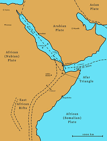
English: Regional map of the Afar Triangle showing the spreading rates of the three limbs (East African Rifts, Red Sea Rift and Aden Ridge) |
| Date | |
| Source | Own work |
| Author | Razashah1 |
Licensing[edit]
I, the copyright holder of this work, hereby publish it under the following license:
This file is licensed under the Creative Commons Attribution 3.0 Unported license.
- You are free:
- to share – to copy, distribute and transmit the work
- to remix – to adapt the work
- Under the following conditions:
- attribution – You must give appropriate credit, provide a link to the license, and indicate if changes were made. You may do so in any reasonable manner, but not in any way that suggests the licensor endorses you or your use.
File history
Click on a date/time to view the file as it appeared at that time.
| Date/Time | Thumbnail | Dimensions | User | Comment | |
|---|---|---|---|---|---|
| current | 16:40, 4 December 2010 | | 1,686 × 2,213 (829 KB) | Razashah1 (talk | contribs) | {{Information |Description={{en|1=Regional map of the Afar Triangle showing the spreading rates of the three limbs (East African Rifts, Red Sea Rift and Aden Ridge)}} |Source={{own}} |Author=Razashah1 |Date=2010-12-04 |Permission= |othe |
You cannot overwrite this file.
File usage on Commons
There are no pages that use this file.
File usage on other wikis
The following other wikis use this file:
- Usage on af.wikipedia.org
- Usage on en.wikipedia.org
- Usage on ha.wikipedia.org