File:Adyar estuary.jpg
(Redirected from File:Adyar estuary .jpg)

Size of this preview: 800 × 364 pixels. Other resolutions: 320 × 146 pixels | 640 × 291 pixels | 1,443 × 657 pixels.
Original file (1,443 × 657 pixels, file size: 249 KB, MIME type: image/jpeg)
Captions
Captions
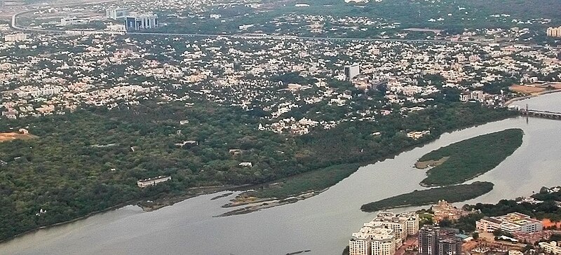
River Adyar in South Chennai emptying into the Bay of Bengal
| Description | Aerial view of the Adyar Estuary and w:Adyar. On the top ind is w:Tidel Park and the w:Chennai MRTS. The gardens belong to the w:Theosophical Society. | ||
| Date | 22 June 05 | ||
| Source | Own work | ||
| Author |
|
||
| Permission (Reusing this file) |
I, the copyright holder of this work, hereby publish it under the following license: This file is licensed under the Creative Commons Attribution-Share Alike 2.5 Generic license.
|
| Camera location | | View this and other nearby images on: OpenStreetMap |
|---|
File history
Click on a date/time to view the file as it appeared at that time.
| Date/Time | Thumbnail | Dimensions | User | Comment | |
|---|---|---|---|---|---|
| current | 12:16, 28 April 2007 | | 1,443 × 657 (249 KB) | Planemad (talk | contribs) | {{Information |Description=Aerial view of the Adyar Estuary and w:Adyar. On the top ind is w:Tidel Park and the w:Chennai MRTS. |Source=own work |Date= 22 June 05 |Author= w:user:PlaneMad |Permission={{self|cc-by-sa-2.5}} |
You cannot overwrite this file.
File usage on Commons
The following 4 pages use this file:
File usage on other wikis
The following other wikis use this file:
- Usage on arz.wikipedia.org
- Usage on azb.wikipedia.org
- Usage on bg.wikipedia.org
- Usage on bn.wikipedia.org
- Usage on ceb.wikipedia.org
- Usage on cs.wikipedia.org
- Usage on de.wikipedia.org
- Usage on en.wikipedia.org
- Usage on es.wikipedia.org
- Usage on fa.wikipedia.org
- Usage on fi.wikipedia.org
- Usage on fr.wikipedia.org
- Usage on hi.wikipedia.org
- Usage on id.wikipedia.org
- Usage on incubator.wikimedia.org
- Usage on io.wikipedia.org
- Usage on it.wikipedia.org
- Usage on jv.wikipedia.org
- Usage on ml.wikipedia.org
- Usage on nl.wikipedia.org
- Usage on no.wikipedia.org
- Usage on pt.wikipedia.org
- Usage on ro.wikipedia.org
- Usage on ru.wikipedia.org
- Usage on ta.wikipedia.org
- Usage on uk.wikipedia.org
- Usage on ur.wikipedia.org
- Usage on www.wikidata.org
- Usage on zh-min-nan.wikipedia.org
- Usage on zh-yue.wikipedia.org