File:Accident at Connolly - 1971 - (1) - geograph.org.uk - 3244836.jpg
Jump to navigation
Jump to search

Size of this preview: 800 × 578 pixels. Other resolutions: 320 × 231 pixels | 640 × 462 pixels | 976 × 705 pixels.
Original file (976 × 705 pixels, file size: 524 KB, MIME type: image/jpeg)
Captions
Captions
Accident at Connolly - 1971 - (1) - geograph.org.uk - 3244836
Summary[edit]
_-_geograph.org.uk_-_3244836.jpg&action=edit§ion=1)
| Description |
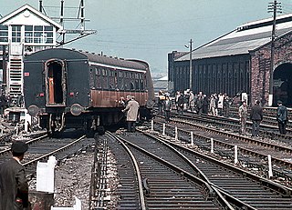
English: Accident at Connolly – 1971 – (1) On the morning of Monday 17 May 1971, the 08.11 train from Howth to Dalkey was running between Killester and the city when a train-lighting dynamo became detached from under one of the coaches. This caused considerable damage to the track and eventually the train derailed at Connolly signal cabin (a former GNR(I) cabin which can be seen on the left). Fortunately, injuries were minor and most of the damage was repaired by the following day, allowing a resumption of normal services. |
| Date | |
| Source | https://www.geograph.ie/photo/3244836 |
| Author | The Carlisle Kid |
| Attribution (required by the license) | The Carlisle Kid / Accident at Connolly – 1971 – (1) / |
| Camera location | | View this and other nearby images on: OpenStreetMap |
|---|
_-_geograph.org.uk_-_3244836.jpg¶ms=053.354227_N_-006.244357_E_globe:Earth_type:camera_source:geograph-irishgrid(O16953519)_heading:45.00&language=en)
| Object location | | View this and other nearby images on: OpenStreetMap |
|---|
_-_geograph.org.uk_-_3244836.jpg¶ms=053.354230_N_-006.244360_E_globe:Earth_class:object_type:object_source:geograph-irishgrid(O16953519)_heading:45.00&language=en)
Licensing[edit]
_-_geograph.org.uk_-_3244836.jpg&action=edit§ion=2)

|
This image was taken from the Geograph project collection. See this photograph's page on the Geograph website for the photographer's contact details. The copyright on this image is owned by The Carlisle Kid and is licensed for reuse under the Creative Commons Attribution-ShareAlike 2.0 license.
|
This file is licensed under the Creative Commons Attribution-Share Alike 2.0 Generic license.
Attribution: The Carlisle Kid
- You are free:
- to share – to copy, distribute and transmit the work
- to remix – to adapt the work
- Under the following conditions:
- attribution – You must give appropriate credit, provide a link to the license, and indicate if changes were made. You may do so in any reasonable manner, but not in any way that suggests the licensor endorses you or your use.
- share alike – If you remix, transform, or build upon the material, you must distribute your contributions under the same or compatible license as the original.
File history
Click on a date/time to view the file as it appeared at that time.
| Date/Time | Thumbnail | Dimensions | User | Comment | |
|---|---|---|---|---|---|
| current | 23:22, 25 January 2022 | | 976 × 705 (524 KB) | Djm-mobile (talk | contribs) | Uploaded a work by [https://www.geograph.org.uk/profile/61944 The Carlisle Kid] from https://www.geograph.ie/photo/3244836 with UploadWizard |
You cannot overwrite this file.
File usage on Commons
The following page uses this file:
_-_geograph.org.uk_-_3244836.jpg&oldid=780429420)