File:Access to the Mawddach Trail at Penmaenpool - geograph.org.uk - 1083502.jpg
Access_to_the_Mawddach_Trail_at_Penmaenpool_-_geograph.org.uk_-_1083502.jpg (640 × 480 pixels, file size: 266 KB, MIME type: image/jpeg)
Captions
Captions
Summary[edit]
| Description |
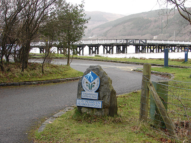
English: Access to the Mawddach Trail at Penmaenpool I like to take a several mile walk at least once a week, using public transport to access the start and end points wherever possible. Most of my walks over the last few weeks have been based on public paths located near the Cambrian Coast Railway line, between Barmouth and Pwllheli. On this occasion, I thought that I might try something a little different and would walk the Mawddach Trail from Penmaenpool to Morfa Mawddach, which has been built on part of the old Ruabon to Barmouth Junction railway line, not far short of 6 miles and part of Sustrans Route 8 http://www.sustrans.org.uk/default.asp?sID=1127403526859#cmsanchorEnglish .
The logistics of public transport access were straightforward; a train to Morfa Mawddach (the current name for what was Barmouth Junction), a couple of miles walk to Fairbourne (as an hors d'oeuvres!), bus from Fairbourne to Penmaenpool and then a train home from Morfa Mawddach at the completion of the walk. A tip here, if you are planning a day out on the Cambrian Coast Railway, with maybe bus travel in Gwynedd, consider using the Tocyn TAITH day ranger ticket which starts at £6.00 with no restriction on travel times. See http://www.gwynedd.gov.uk/gwy_doc.asp?cat=2772&doc=16297&Language=1 for more details. The prospect was quite inviting, with a forecast of good winter sunshine and of course, the beautiful Mawddach estuary to view. In the event, I was somewhat disappointed. The promised sunshine didn't really materialise - a combination of stubborn cloud and the local geography partly blocking the low winter sun. Perhaps the least attractive aspect of the walk was monotony. When using ordinary public rights of way, there is always a sense of adventure - venturing into the unknown! In using this Sustrans route, the very things that made it ideal for railway purposes work against it from the point of view of a walking route; very flat, long, seemingly endless, straight sections. All very predictable and so none of the surprises that make most country walks a challenge but enjoyable. Still, I mustn't be churlish. No doubt cyclists enjoy it and at least the route hasn't been converted into a road! On the plus side, The Mawddach Estuary really is magnificent, arguably at its best in 'moody' winter conditions, and this trail is one of the best ways to view it. However, I doubt that I will plan another walk along a Sustrans route. |
| Date | |
| Source | From geograph.org.uk |
| Author | OLU |
| Camera location | | View this and other nearby images on: OpenStreetMap |
|---|
_heading:270.00&language=en)
| Object location | | View this and other nearby images on: OpenStreetMap |
|---|
_heading:270.00&language=en)
Licensing[edit]

|
This image was taken from the Geograph project collection. See this photograph's page on the Geograph website for the photographer's contact details. The copyright on this image is owned by OLU and is licensed for reuse under the Creative Commons Attribution-ShareAlike 2.0 license.
|
- You are free:
- to share – to copy, distribute and transmit the work
- to remix – to adapt the work
- Under the following conditions:
- attribution – You must give appropriate credit, provide a link to the license, and indicate if changes were made. You may do so in any reasonable manner, but not in any way that suggests the licensor endorses you or your use.
- share alike – If you remix, transform, or build upon the material, you must distribute your contributions under the same or compatible license as the original.
File history
Click on a date/time to view the file as it appeared at that time.
| Date/Time | Thumbnail | Dimensions | User | Comment | |
|---|---|---|---|---|---|
| current | 09:56, 24 February 2011 | | 640 × 480 (266 KB) | GeographBot (talk | contribs) | == {{int:filedesc}} == {{Information |description={{en|1=Access to the Mawddach Trail at Penmaenpool I like to take a several mile walk at least once a week, using public transport to access the start and end points wherever possible. Most of my walks ove |
You cannot overwrite this file.
File usage on Commons
There are no pages that use this file.