File:A dammed pond on Pincey Brook, Gibberd Garden Essex England 01.JPG

Original file (3,648 × 5,472 pixels, file size: 17.57 MB, MIME type: image/jpeg)
Captions
Captions
Summary[edit]
| Description |
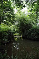
English: A dammed pond on Pincey Brook at The Gibberd Garden, in the Harlow District of Essex, England. Pincey Brook rises at Stansted Airport, runs south between the villages of Hatfield Broad Oak and Hatfield Heath, turns west and under the M11 motorway, passes the Gibberd Garden at its north, and then enters the River Stort at the north of Harlow. The Brook passes through the parishes of Takeley, Hatfield Broad Oak, Hatfield Heath, Matching, and Sheering. |
| Date | |
| Source | Own work |
| Author | Acabashi |
| Permission (Reusing this file) |
Permission is given to reuse this file under conditions stipulated by Creative Commons Attribution-ShareAlike 4.0 International licensing. Before download and reuse, please consult the Wikimedia page Reusing content outside Wikimedia. Attribution must be given for republishing in any media, and requires the name of the creator (Acabashi), and a link to the content here. If you change, manipulate or add to the file, or use the file, or parts of it, within other works, on publication in any media you must still attribute the original file to the creator here and provide a link. In all cases you must add a follow-on Attribution-ShareAlike 4.0 International copyright, licensing and disclaimer notices indicating that any changes, additions and manipulation you made are freely available under Creative Commons licensing. Put simply, you must not re-publish this file without attribution, and whether or not you have built on it, or with it, you must not insist on your own copyright notification stopping others from freely using it or your variation. |
| Camera location | | View this and other nearby images on: OpenStreetMap |
|---|
Licensing[edit]
- You are free:
- to share – to copy, distribute and transmit the work
- to remix – to adapt the work
- Under the following conditions:
- attribution – You must give appropriate credit, provide a link to the license, and indicate if changes were made. You may do so in any reasonable manner, but not in any way that suggests the licensor endorses you or your use.
- share alike – If you remix, transform, or build upon the material, you must distribute your contributions under the same or compatible license as the original.
File history
Click on a date/time to view the file as it appeared at that time.
| Date/Time | Thumbnail | Dimensions | User | Comment | |
|---|---|---|---|---|---|
| current | 19:25, 12 July 2015 | | 3,648 × 5,472 (17.57 MB) | Acabashi (talk | contribs) | User created page with UploadWizard |
You cannot overwrite this file.
File usage on Commons
There are no pages that use this file.