File:A chart of New York Harbour - with the soundings, views of l - (3989956313).jpg

Original file (565 × 760 pixels, file size: 61 KB, MIME type: image/jpeg)
Captions
Captions
Summary[edit]
.jpg&action=edit§ion=1)
| Description |
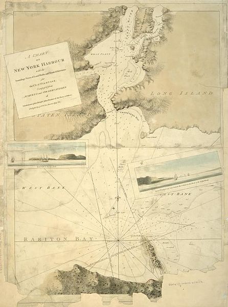
English: Digital ID: 434588. A chart of New York Harbour : with the soundings, views of land marks and nautical directions for the use of pilotage / composed from surveys and observations of lieutenants John Knight, John Hunter of the Navy & others.. Des Barres, Joseph F. W. (Joseph Frederick Wallet) -- Publisher. Ma[y 1779?] Notes: Appears in Des Barres's Atlantic Neptune. National Endowment for the Humanities Grant for Access to Early Maps of the Middle Atlantic Seaboard. NYPL copy appears to have been printed from a plate on which publication date has been mostly worn off. NYPL copy lacks lower right corner of map and most of lower margin. Relief shown by hachures and shading, and depths shown by soundings. Inset views: Bond Hollow bearing s. b[y] e. -- Mount Pleasant half way between the cedars on the Hook & the light house. |
| Date | |
| Source | https://www.flickr.com/photos/nypl/3989956313/ |
| Author | New York Public Library |
| Permission (Reusing this file) |
At the time of upload, the image license was automatically confirmed using the Flickr API. For more information see Flickr API detail. |
| Flickr sets |
|
| Flickr tags |
|
| Camera location | | View this and other nearby images on: OpenStreetMap |
|---|
.jpg¶ms=040.666577_N_-074.045104_E_globe:Earth_type:camera__&language=en)
Licensing[edit]
.jpg&action=edit§ion=2)
This image was taken from Flickr's The Commons. The uploading organization may have various reasons for determining that no known copyright restrictions exist, such as:
More information can be found at https://flickr.com/commons/usage/. Please add additional copyright tags to this image if more specific information about copyright status can be determined. See Commons:Licensing for more information. |
| This image was originally posted to Flickr by New York Public Library at https://flickr.com/photos/32951986@N05/3989956313. It was reviewed on 26 November 2016 by FlickreviewR and was confirmed to be licensed under the terms of the No known copyright restrictions. |
File history
Click on a date/time to view the file as it appeared at that time.
| Date/Time | Thumbnail | Dimensions | User | Comment | |
|---|---|---|---|---|---|
| current | 18:28, 26 November 2016 | | 565 × 760 (61 KB) | Fæ (talk | contribs) | New York Public Library, Set 72157622419084487, ID 3989956313, Original title A chart of New York Harbour : with the soundings, views of l... |
You cannot overwrite this file.
File usage on Commons
There are no pages that use this file.
.jpg&oldid=777951396)