File:A SEQUEL of the Seat of WAR in the WEST INDIES, Containing - Emanuel Bowen, 1740 - BL Maps K.Top.124.21 (BLL01018640977).jpg

Original file (4,962 × 6,306 pixels, file size: 6.39 MB, MIME type: image/jpeg)
Captions
Captions
| Title |
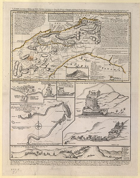
English: A SEQUEL of the Seat of WAR in the WEST INDIES, Containing : (1) a Map of the Isthmus of Panamá, exhibiting the Roads with the Course of the River Châgré thro the same (2) Curious Perspective Views of the Harbour, Town and Castles of Puerto Bello, as sent over by Commodore Brown (3) the Appearance at Sea of San Juan de Puerto Rico, with it's Castles from Admiral Vernon's own draught. the whole illustrated with remarks. |
||||||||||||||||||||||||||||||||||||||||||||||||||
| DescriptionA SEQUEL of the Seat of WAR in the WEST INDIES, Containing - Emanuel Bowen, 1740 - BL Maps K.Top.124.21 (BLL01018640977).jpg |
English: Map published in the context of the War of Jenkins' Ear and the capture of Porto Belo in November 1739. Admiral Edward Vernon's successful attack was used in a propaganda campaign by the British government. Insets of the map, some by the E. Vernon, correspond with the different stages of the siege: an attack of the fort of San Felipe ("Iron Castle" or "Castillo del Hierro") and the subsequent attack of the Castle of Santiago de la Gloria ("Castle Gloria"). Includes an engraving note: "E. Bowen Sculp." Includes an inset of the profile of "Town & Castle of Chágré before it was demolish'd". Includes an inset: "Perspective Views of the Harbour, Town, and Castles of PUERTO BELLO", by C. Brown Includes an inset: "Plan of Castillo del Hierro or the Iron Castle", by E. Vernon. Includes an inset: "Plan of the Town of PUERTO BELLO and the adjacent Forts", with a key, and "Plan of Castillo de la Gloria". Includes an inset: "The Appearance of San Juan de PUERTO RICO", with a key, by E. Vernon. Includes an inset: "View of GLORIA CASTLE". Includes an inset: "View of the IRON CASTLE". Includes descriptions of Portobelo and Panama. Includes keys. Includes notes with regard to movements of goods (treasure) and military forces. Includes towns, ports, harbours, castles, fortification, defences, rivers, roads and mountains. Relief shown pictorially. |
||||||||||||||||||||||||||||||||||||||||||||||||||
| Date | |||||||||||||||||||||||||||||||||||||||||||||||||||
| Source |
Part of King George III's Topographical Collection. Donated to the nation by George IV. Please do not overwrite this file. Any cropped or modified version should be uploaded with a new name and linked in the "
|
||||||||||||||||||||||||||||||||||||||||||||||||||
| Creator |
Cartographer:
creator QS:P170,Q330967 |
||||||||||||||||||||||||||||||||||||||||||||||||||
| Contributor |
Contributor:
creator QS:P170,Q5075827
Bookseller:
creator QS:P170,Q56649446
Contributor:
creator QS:P170,Q713145 |
||||||||||||||||||||||||||||||||||||||||||||||||||
| Permission (Reusing this file) |
|
||||||||||||||||||||||||||||||||||||||||||||||||||
| Geotemporal data | |||||||||||||||||||||||||||||||||||||||||||||||||||
| Map location | Portobelo (Panama) | ||||||||||||||||||||||||||||||||||||||||||||||||||
| Scale | 1:4,100,000 | ||||||||||||||||||||||||||||||||||||||||||||||||||
| OpenStreetMap zoom level | 8 | ||||||||||||||||||||||||||||||||||||||||||||||||||
| Bounding box |
|
||||||||||||||||||||||||||||||||||||||||||||||||||
| Georeferencing | Georeference the map in Wikimaps Warper If inappropriate please set warp_status = skip to hide. | ||||||||||||||||||||||||||||||||||||||||||||||||||
| Bibliographic data | |||||||||||||||||||||||||||||||||||||||||||||||||||
| Language | English | ||||||||||||||||||||||||||||||||||||||||||||||||||
| Place of publication | [London] : Published pursuant to Act of Parliament July 8th. 1740 by E. Bowen & Sold by Geo: Foster at ye White Horse in St. Pauls Church Yard London. | ||||||||||||||||||||||||||||||||||||||||||||||||||
| Archival data | |||||||||||||||||||||||||||||||||||||||||||||||||||
| Collection |
institution QS:P195,Q23308 |
||||||||||||||||||||||||||||||||||||||||||||||||||
| Accession number |
British Library Maps K.Top.124.21 |
||||||||||||||||||||||||||||||||||||||||||||||||||
| Dimensions | 20 x 35 cm on sheet 44 x 36 cm | ||||||||||||||||||||||||||||||||||||||||||||||||||
| Metadata note InfoField | Initial version of this page based on information from the BL catalogue entry, updated 2017-12-08. Used with permission. Accessed 2018-09-18. | ||||||||||||||||||||||||||||||||||||||||||||||||||
File history
Click on a date/time to view the file as it appeared at that time.
| Date/Time | Thumbnail | Dimensions | User | Comment | |
|---|---|---|---|---|---|
| current | 11:47, 22 September 2018 |  | 4,962 × 6,306 (6.39 MB) | JhealdBot (talk | contribs) | JhealdBot(6): test upload |
You cannot overwrite this file.
File usage on Commons
There are no pages that use this file.


