File:A Pocket Companion of ye Roads of ye North Part of Great Britain Called Scotland. Containing all ye Cities, Market Towns, Boroughs &c. the principal Roads, with ye Computed Miles from Town to Town - To His Grace... - btv1b530567389.jpg

Original file (4,128 × 4,440 pixels, file size: 3.08 MB, MIME type: image/jpeg)
Captions
Captions
Summary[edit]
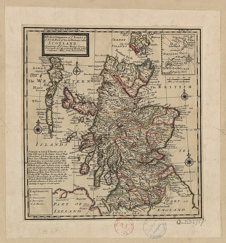
| English: A Pocket Companion of ye Roads of ye North Part of Great Britain Called Scotland, Containing All ye Cities, Market Towns, Boroughs &c., the Principal Roads with ye Computed Miles from Town to Town
( |
|||||||||||||||||||||||||||
|---|---|---|---|---|---|---|---|---|---|---|---|---|---|---|---|---|---|---|---|---|---|---|---|---|---|---|---|
| Author |
|
||||||||||||||||||||||||||
| Title |
English: A Pocket Companion of ye Roads of ye North Part of Great Britain Called Scotland, Containing All ye Cities, Market Towns, Boroughs &c., the Principal Roads with ye Computed Miles from Town to Town |
||||||||||||||||||||||||||
| Description |
English: A map of Scotland c. 1718 with its roads and universities marked.
Français : Sujet : Écosse, Royaume d'
Échelle(s) : Miles of Great Britain 40 [= 3,5 cm] Appartient à l’ensemble documentaire : AnvilEur Appartient à l’ensemble documentaire : MAEDI008 Appartient à l’ensemble documentaire : MAEDIGen0 Couverture : Royaume-Uni – Écosse Langue : anglais Éditeur : Sold by Herman Moll (London) |
||||||||||||||||||||||||||
| Date | 1718 | ||||||||||||||||||||||||||
| Dimensions | height: 26.5 cm (10.4 in); width: 29 cm (11.4 in) | ||||||||||||||||||||||||||
| Collection |
|
||||||||||||||||||||||||||
| References |
Français : Notice de recueil : http://catalogue.bnf.fr/ark:/12148/cb40577015h
Appartient à : Collection d'Anville ; 02488 Notice du catalogue : http://catalogue.bnf.fr/ark:/12148/cb41160957g |
||||||||||||||||||||||||||
| Source/Photographer |
Français : Bibliothèque nationale de France, département Cartes et plans, GE DD-2987 (2488)
Bibliothèque nationale de France |
||||||||||||||||||||||||||
| Permission (Reusing this file) |
|
||||||||||||||||||||||||||


| Annotations | This image is annotated: View the annotations at Commons |
File history
Click on a date/time to view the file as it appeared at that time.
| Date/Time | Thumbnail | Dimensions | User | Comment | |
|---|---|---|---|---|---|
| current | 21:36, 26 July 2022 | | 4,128 × 4,440 (3.08 MB) | Gzen92Bot (talk | contribs) | Gallica btv1b530567389 |
You cannot overwrite this file.
File usage on Commons
The following page uses this file: