File:A New Description of Kent (BM 1853,0611.123).jpg
Original file (2,239 × 889 pixels, file size: 591 KB, MIME type: image/jpeg)
Captions
Captions
Summary[edit]
.jpg&action=edit§ion=1)
| A New Description of Kent
( |
||||||||||||||||||||||||
|---|---|---|---|---|---|---|---|---|---|---|---|---|---|---|---|---|---|---|---|---|---|---|---|---|
| Artist |
Print made by: Wenceslaus Hollar
|
|||||||||||||||||||||||
| Title |
A New Description of Kent |
|||||||||||||||||||||||
| Description |
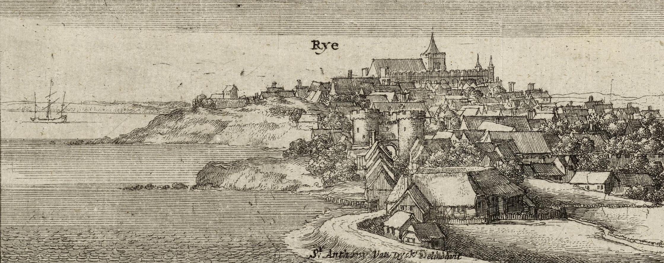
English: Map of Kent, with views of Rye and Dover in the upper left. and upper right. respectively. 1659
Engraving and etching on two plates side by side, on two conjoined sheets of paper |
|||||||||||||||||||||||
| Date | 1659 | |||||||||||||||||||||||
| Medium | paper | |||||||||||||||||||||||
| Dimensions |
|
|||||||||||||||||||||||
| Collection |
|
|||||||||||||||||||||||
| Current location |
Prints and Drawings |
|||||||||||||||||||||||
| Accession number |
1853,0611.123 |
|||||||||||||||||||||||
| Notes |
The only work by Hollar is the two views, of Rye and Dover, the rest being by Whitwell; Hollar's drawing of Rye (Sprinzels 367, Huntington Library) was made after an original by Van Dyck (Vey 288, Pierpoint Morgan Library III 178); according to Pennington, this state appeared in the 1664 edition of Thomas Phillipott's 'Vallare Cantianum, or Kent surveyed and illustrated' (not the 1659 edition). The map itself was first issued in 1596. |
|||||||||||||||||||||||
| Source/Photographer | https://www.britishmuseum.org/collection/object/P_1853-0611-123 | |||||||||||||||||||||||
| Permission (Reusing this file) |
© The Trustees of the British Museum, released as CC BY-NC-SA 4.0 | |||||||||||||||||||||||
| Other versions |
.jpg) .jpg) |
|||||||||||||||||||||||
Licensing[edit]
.jpg&action=edit§ion=2)
This image is in the public domain because it is a mere mechanical scan or photocopy of a public domain original, or – from the available evidence – is so similar to such a scan or photocopy that no copyright protection can be expected to arise. The original itself is in the public domain for the following reason:
This tag is designed for use where there may be a need to assert that any enhancements (eg brightness, contrast, colour-matching, sharpening) are in themselves insufficiently creative to generate a new copyright. It can be used where it is unknown whether any enhancements have been made, as well as when the enhancements are clear but insufficient. For known raw unenhanced scans you can use an appropriate {{PD-old}} tag instead. For usage, see Commons:When to use the PD-scan tag.  | ||||
File history
Click on a date/time to view the file as it appeared at that time.
| Date/Time | Thumbnail | Dimensions | User | Comment | |
|---|---|---|---|---|---|
| current | 12:53, 4 February 2024 | 2,239 × 889 (591 KB) | Enyavar (talk | contribs) | Cropped 10 % horizontally, 31 % vertically, rotated 0.6° using CropTool with precise mode. | |
| 21:14, 15 May 2020 |  | 2,500 × 1,291 (861 KB) | Copyfraud (talk | contribs) | British Museum public domain uploads (Copyfraud/BM) Maps in the British Museum 1659 #424/703 |
You cannot overwrite this file.
File usage on Commons
The following 4 pages use this file:
.jpg)
.jpg)
.jpg&oldid=848904987)