File:AZ-districts-109-07.png
(Redirected from File:AZ-districts-109-07.gif)
No higher resolution available.
AZ-districts-109-07.png (639 × 379 pixels, file size: 29 KB, MIME type: image/png)
Captions
Captions
Add a one-line explanation of what this file represents
Transwiki approved by: w:en:User:Dmcdevit
This image was copied from wikipedia:en. The original description was:
Summary[edit]
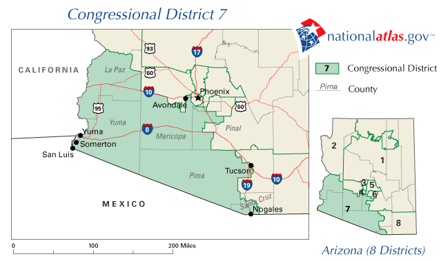
| Description | A map of Arizona's 2nd Congressional District, including southwest Arizona. Major cities in this district are Yuma, Somerton, San Luis, Avondale, and Nogales. |
| Date | Unknown date |
| Source | http://nationalatlas.gov/printable/congress.html ([1]) |
| Author | w:en:National Atlas of the United States |
![[1]](http://nationalatlas.gov/printable/images/preview/congdist/AZ07_109.gif)
Licensing[edit]
This map was obtained from an edition of the National Atlas of the United States. Like almost all works of the U.S. federal government, works from the National Atlas are in the public domain in the United States.
Online access: NationalAtlas.gov | 1970 print edition: Library of Congress, Perry-Castañeda Library
|
Original upload log[edit]
| date/time | username | resolution | size | edit summary |
|---|---|---|---|---|
| 04:21, 9 April 2006 | w:en:User:Deville | 639×379 | 27 KB |
Image description page history[edit]
| link | date/time | username | edit summary |
|---|---|---|---|
| http://en.wikipedia.org/w/index.php?title=Image:AZ-districts-109-07.gif&redirect=no&oldid=108280989 | 07:26, 10 September 2007 | w:en:User:Dmcdevit | |
| http://en.wikipedia.org/w/index.php?title=Image:AZ-districts-109-07.gif&redirect=no&oldid=108280989 | 07:37, 15 February 2007 | w:en:User:Iamunknown | |
| http://en.wikipedia.org/w/index.php?title=Image:AZ-districts-109-07.gif&redirect=no&oldid=47650883 | 04:21, 9 April 2006 | w:en:User:Deville |
Original upload log[edit]
| Date/Time | Dimensions | User | Comment |
|---|---|---|---|
| 10 September 2007, 18:37:48 | 639 × 379 (27708 bytes) | BetacommandBot (talk · contribs) | Transwiki approved by: [[w:en:User:Dmcdevit]] This image was copied from wikipedia:en. The original description was: == Summary == {{Information | Description = A map of Arizona's 2nd Congressional District, including southwest Arizona. Major cities in |
File history
Click on a date/time to view the file as it appeared at that time.
| Date/Time | Thumbnail | Dimensions | User | Comment | |
|---|---|---|---|---|---|
| current | 17:12, 4 August 2014 | | 639 × 379 (29 KB) | GifTagger (talk | contribs) | Bot: Converting file to superior PNG file. (Source: AZ-districts-109-07.gif). This GIF was problematic due to non-greyscale color table. |
You cannot overwrite this file.
File usage on Commons
The following 2 pages use this file:
File usage on other wikis
The following other wikis use this file:
- Usage on en.wikipedia.org
- Usage on fr.wikipedia.org
- Usage on pt.wikipedia.org