File:AN AREA ALONG THE MISSOURI RIVER NEAR WHITE CLOUD, KANSAS AND TROY IN DONIPHAN COUNTY IN THE NORTHEAST CORNER OF THE... - NARA - 557159.jpg

Original file (3,000 × 2,020 pixels, file size: 1.19 MB, MIME type: image/jpeg)
Captions
Captions
Summary[edit]
| Author |
Duncan, Patricia D., 1932-, Photographer (NARA record: 8464441) |
||||||||||||||||||||||||||
| Record creator | Environmental Protection Agency. (12/02/1970 - ) | ||||||||||||||||||||||||||
| Title |
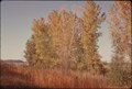
AN AREA ALONG THE MISSOURI RIVER NEAR WHITE CLOUD, KANSAS AND TROY IN DONIPHAN COUNTY IN THE NORTHEAST CORNER OF THE STATE IN THE FOREGROUND IS RARE AND UNDISTURBED (UNPLOWED) TALL GRASS WITH A STAND OF LARGE COTTONWOOD TREES BEHIND. IN THE DISTANCE IS A TYPICAL LOESS BLUFF, A GLACIER-FORMED BLUFF OF SOLID EARTH. WHEN THE SETTLERS CAME TO THAT AREA OF KANSAS COTTONWOODS WERE FOUND ALL ALONG THE RIVER. IT WAS CALLED "KANSAS MAHOGANY" |
||||||||||||||||||||||||||
| Depicted place |
White Cloud (Doniphan county, Kansas, United States, North and Central America) inhabited place (39°58′01″N 95°16′59″W / 39.967°N 95.283°W; NARA geographical record) |
||||||||||||||||||||||||||
| Date | October 1974 | ||||||||||||||||||||||||||
| Collection |
|
||||||||||||||||||||||||||
| Record ID |
NAIL Control Number: NWDNS-412-DA-14707
|
||||||||||||||||||||||||||
| Source | U.S. National Archives and Records Administration | ||||||||||||||||||||||||||
| Other versions |
Please do not overwrite this file: any restoration work should be uploaded with a new name and linked in this page's "other versions=" parameter, so that this file represents the exact file found in the NARA catalog record to which it links. The metadata on this page was imported directly from NARA's catalog record; additional descriptive text may be added by Wikimedians to the template below with the "description=" parameter, but please do not modify the other fields.
|
||||||||||||||||||||||||||


Licensing[edit]
This file was provided to Wikimedia Commons by the National Archives and Records Administration as part of a cooperation project. The National Archives and Records Administration provides images depicting American and global history which are public domain or licensed under a free license.
|
This image (or other media) is a work of an Environmental Protection Agency employee, taken or made as part of that person's official duties. As works of the U.S. federal government, all EPA images are in the public domain.
|
||
File history
Click on a date/time to view the file as it appeared at that time.
| Date/Time | Thumbnail | Dimensions | User | Comment | |
|---|---|---|---|---|---|
| current | 04:55, 8 October 2011 | | 3,000 × 2,020 (1.19 MB) | US National Archives bot (talk | contribs) | == {{int:filedesc}} == {{NARA-image-full | Title = AN AREA ALONG THE MISSOURI RIVER NEAR WHITE CLOUD, KANSAS AND TROY IN DONIPHAN COUNTY IN THE NORTHEAST CORNER OF THE STATE IN THE FOREGROUND IS RARE AND UNDISTURBED (UNPLOWED) TALL GRA |
You cannot overwrite this file.
File usage on Commons
The following 4 pages use this file:
- Fall foliage of West Virginia by color
- Tree leaves of West Virginia
- File:AN AREA ALONG THE MISSOURI RIVER NEAR WHITE CLOUD, KANSAS AND TROY IN DONIPHAN COUNTY IN THE NORTHEAST CORNER OF THE... - NARA - 557159.jpg
- File:AN AREA ALONG THE MISSOURI RIVER NEAR WHITE CLOUD, KANSAS AND TROY IN DONIPHAN COUNTY IN THE NORTHEAST CORNER OF THE... - NARA - 557159.tif