File:AMH-7755-KB Map of Central American and the Caribbean region.jpg
Original file (2,400 × 1,992 pixels, file size: 990 KB, MIME type: image/jpeg)
Captions
Captions
Summary[edit]
Nederlands: Kaart van Midden-Amerika en het Caribisch gebied
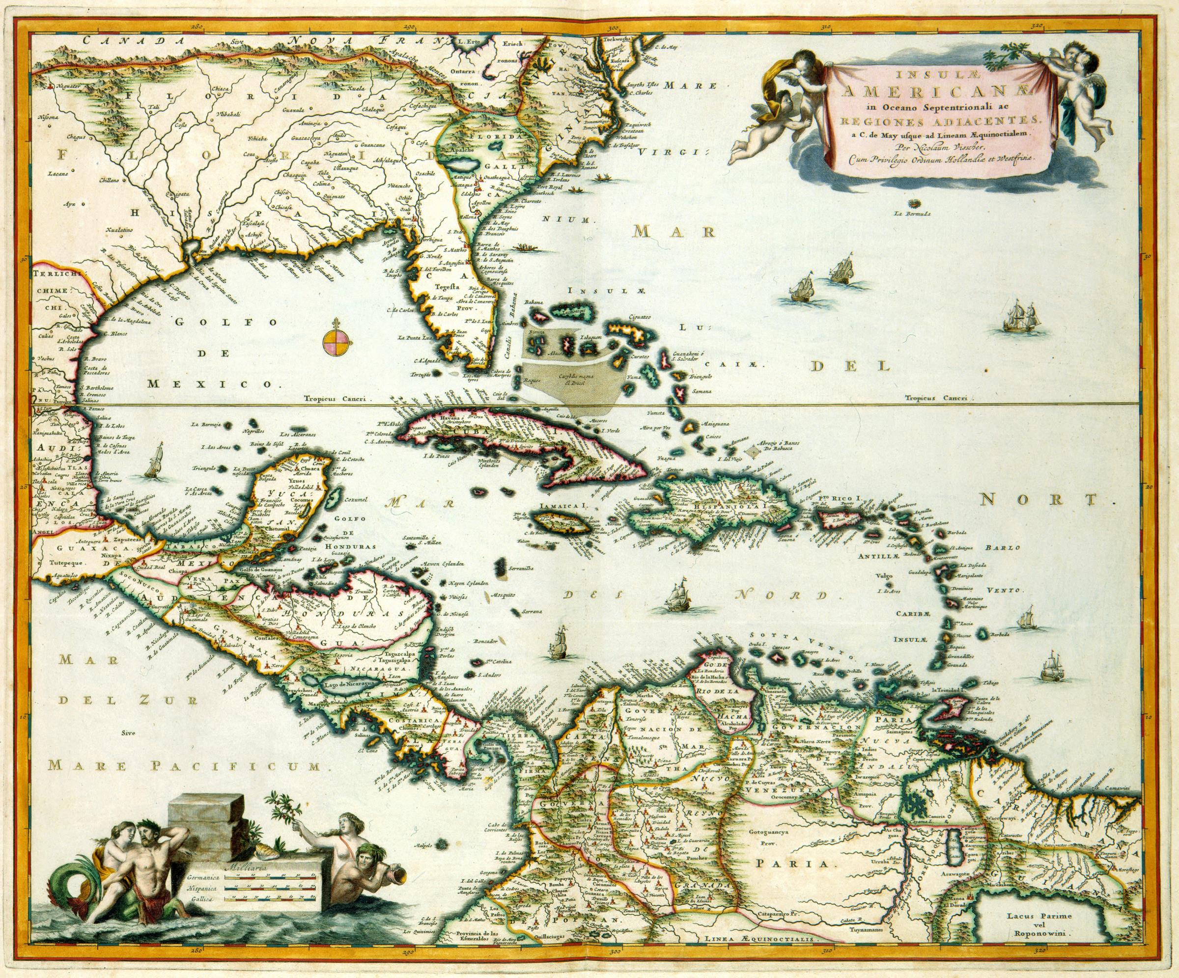
English: Map of Central American and the Caribbean region( |
||||||||||||||||||||||||||
|---|---|---|---|---|---|---|---|---|---|---|---|---|---|---|---|---|---|---|---|---|---|---|---|---|---|---|
| Author |
Nederlands: Nicolaas Visscher II (graveur / etser)
English: Nicolaas Visscher II (engraver / etcher) |
|||||||||||||||||||||||||
| Title |
Nederlands: Kaart van Midden-Amerika en het Caribisch gebied
English: Map of Central American and the Caribbean region |
|||||||||||||||||||||||||
| Description |
Nederlands: Kaart van Midden-Amerika en het Caribisch gebied.
Insulae Americanae in Oceano Septentrionali ac Regiones Adiacentes, a C. de May usque ad Lineam AEquinoctialem. Deze kaart van Midden-Amerika werd gepubliceerd door Nicolaas Visscher II (1649-1708). Het kaartbeeld is vermoedelijk gebaseerd op oudere kaarten die aan het begin van de 17de eeuw in Amsterdam waren uitgegeven. Pas aan het einde van de 17de eeuw onderging dit kaartbeeld onder invloed van de Franse kartografen grote veranderingen. Cf. Koninklijke Bibliotheek, Den Haag, inv. nr. 185 B 14 deel II, na p. 172.English: Map of Central America and the Caribbean region. -Insulae Americanae in Oceano Septentrionali ac Regiones Adiacentes, a C. de May usque ad Lineam AEquinoctialem.
This map of Central America was published by Nicolaas Visscher II (1649-1708). The map orientation could be based on older maps that were published in Amsterdam at the beginning of the 17th century. It was only at the end of the 17th century that this map orientation underwent major changes, due to the influence of French cartographers. Cf. Koninklijke Bibliotheek, The Hague, inv. nr. 185 B 14 part II, after p.172. |
|||||||||||||||||||||||||
| Date | 1681 | |||||||||||||||||||||||||
| Medium |
Nederlands: ingekleurde gravure op papier
English: coloured engraving on paper |
|||||||||||||||||||||||||
| Dimensions | height: 56 cm (22 in); width: 46 cm (18.1 in) | |||||||||||||||||||||||||
| Collection |
|
|||||||||||||||||||||||||
| Accession number |
1049B13_080 |
|||||||||||||||||||||||||
| Inscriptions |
Insulae Americanae in Oceano Septentrionali ac Regiones Adiacentes, a C. de May usque ad Lineam AEquinoctialem
author: Per Nicolaum Visscher, Cum Privilegio Ordinum Hollandiae et Westfrisiae |
|||||||||||||||||||||||||
| Notes |
English: Subjects: chart / map / plan, banderole / cartouche / ornamentation, compass / dial, ship / vessel, Person
Nederlands: Onderwerpen: plattegrond / kaart, banderol / cartouche / versiering, kompas / windroos, schip / vaartuig, Persoon
English: Post: this image is related to a WIC trading post called Anguilla |
|||||||||||||||||||||||||
| Source/Photographer |
|
|||||||||||||||||||||||||
| Permission (Reusing this file) |
|
|||||||||||||||||||||||||

| Object location | | View this and other nearby images on: OpenStreetMap |
|---|
File history
Click on a date/time to view the file as it appeared at that time.
| Date/Time | Thumbnail | Dimensions | User | Comment | |
|---|---|---|---|---|---|
| current | 14:34, 10 June 2014 | | 2,400 × 1,992 (990 KB) | HuskyBot (talk | contribs) | == {{int:filedesc}} == {{Artwork |title = {{nl|1=Kaart van Midden-Amerika en het Caribisch gebied}} {{en|1=Map of Central American and the Caribbean region}} |description = {{nl|1=Kaart van Midden-Amerika en he... |
You cannot overwrite this file.
File usage on Commons
The following page uses this file: