File:AMH-7747-KB Map of Bahia de Todos os Sanctos.jpg

Original file (2,400 × 1,859 pixels, file size: 789 KB, MIME type: image/jpeg)
Captions
Captions
Summary[edit]
Nederlands: Kaart van Bahia de Todos os Sanctos
English: Map of Bahia de Todos os Sanctos( |
|||||||||||||||||||||||||||||||||||||||||||||||||||||||||||||||||||||||||||
|---|---|---|---|---|---|---|---|---|---|---|---|---|---|---|---|---|---|---|---|---|---|---|---|---|---|---|---|---|---|---|---|---|---|---|---|---|---|---|---|---|---|---|---|---|---|---|---|---|---|---|---|---|---|---|---|---|---|---|---|---|---|---|---|---|---|---|---|---|---|---|---|---|---|---|---|
| Author |
Nederlands: Joan Blaeu sr. (uitgever), Frans Post (toegeschreven aan landmeter/kaartenmaker), Georg Marcgraf (toegeschreven aan landmeter/kaartenmaker)
English: Joan Blaeu sr. (publisher), Frans Post (assigned to land surveyor / mapmaker), Georg Marcgraf (assigned to land surveyor / mapmaker) |
||||||||||||||||||||||||||||||||||||||||||||||||||||||||||||||||||||||||||
| Title |
Nederlands: Kaart van Bahia de Todos os Sanctos
English: Map of Bahia de Todos os Sanctos |
||||||||||||||||||||||||||||||||||||||||||||||||||||||||||||||||||||||||||
| Description |
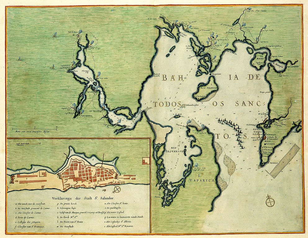
Nederlands: Kaart van Bahia de Todos os Sanctos.
Sinus Omnium Sanctorum. Rechtsonder: No: 31. In de inzet zijn legendanummers gegeven en verklaard. Op de kaart is te zien hoe in 1638 de vloot van Johan Maurits van Nassau-Siegen de baai in vaart om de stad Salvador te veroveren op de Portugezen. Deze slaagde daar echter niet in. In 1624 en 1625 was de stad enige maanden in bezit van de WIC. Eerder werd de kaart gepubliceerd in: C. Barlaeus, 'Rerum per octennium in Brasilia', Amsterdam 1647. Cf. Koninklijke Bibliotheek, Den Haag, inv. nr. 1043 B 14, na p. 78 en Rijksmuseum, Amsterdam, inv. nr. NG-501-96.English: Map of Bahia de Todos os Sanctos.
Sinus Omnium Sanctorum. Bottom right: No: 31. The numbers of the key are given and explicated in the inset. The chart shows how, in 1638, the fleet commanded by Johan Maurits van Nassau-Siegen sails into the bay to capture the city of Salvador from the Portuguese. However, the fleet did not succeed in its intention. In 1624 and 1625 the city was held by the WIC for several months. The chart was previously published in: C. Barlaeus, 'Rerum per octennium in Brasilia', Amsterdam 1647. Cf. Koninklijke Bibliotheek, The Hague, inv. nr. 1043 B 14, after p. 78 and Rijksmuseum, Amsterdam, inv. nr. NG-501-96. |
||||||||||||||||||||||||||||||||||||||||||||||||||||||||||||||||||||||||||
| Date | between 1640 and 1665 | ||||||||||||||||||||||||||||||||||||||||||||||||||||||||||||||||||||||||||
| Medium |
Nederlands: ingekleurde gravure op papier
English: coloured engraving on paper |
||||||||||||||||||||||||||||||||||||||||||||||||||||||||||||||||||||||||||
| Dimensions | height: 52 cm (20.4 in); width: 39 cm (15.3 in) | ||||||||||||||||||||||||||||||||||||||||||||||||||||||||||||||||||||||||||
| Collection |
|
||||||||||||||||||||||||||||||||||||||||||||||||||||||||||||||||||||||||||
| Accession number |
1049B13_093 |
||||||||||||||||||||||||||||||||||||||||||||||||||||||||||||||||||||||||||
| Inscriptions |
Sinus Omnium Sanctorum
|
||||||||||||||||||||||||||||||||||||||||||||||||||||||||||||||||||||||||||
| Notes |
English: Subjects: chart / map / plan, key, compass / dial, ship / vessel, blockade / naval battle
Nederlands: Onderwerpen: plattegrond / kaart, legenda, kompas / windroos, schip / vaartuig, blokkade / zeeslag
English: Post: this image is related to a WIC trading post called Salvador |
||||||||||||||||||||||||||||||||||||||||||||||||||||||||||||||||||||||||||
| Source/Photographer |
|
||||||||||||||||||||||||||||||||||||||||||||||||||||||||||||||||||||||||||
| Permission (Reusing this file) |
|
||||||||||||||||||||||||||||||||||||||||||||||||||||||||||||||||||||||||||
.jpg)
.jpg)

| Object location | | View this and other nearby images on: OpenStreetMap |
|---|
File history
Click on a date/time to view the file as it appeared at that time.
| Date/Time | Thumbnail | Dimensions | User | Comment | |
|---|---|---|---|---|---|
| current | 14:32, 10 June 2014 | | 2,400 × 1,859 (789 KB) | HuskyBot (talk | contribs) | == {{int:filedesc}} == {{Artwork |title = {{nl|1=Kaart van Bahia de Todos os Sanctos}} {{en|1=Map of Bahia de Todos os Sanctos}} |description = {{nl|1=Kaart van Bahia de Todos os Sanctos. ''Sinus Omnium Sanct... |
You cannot overwrite this file.
File usage on Commons
The following 2 pages use this file:
File usage on other wikis
The following other wikis use this file:
- Usage on pt.wikipedia.org