File:AMH-7698-NA Fort St. Sebastian at Chama.jpg
Original file (2,400 × 1,897 pixels, file size: 602 KB, MIME type: image/jpeg)
Captions
Captions
Summary[edit]
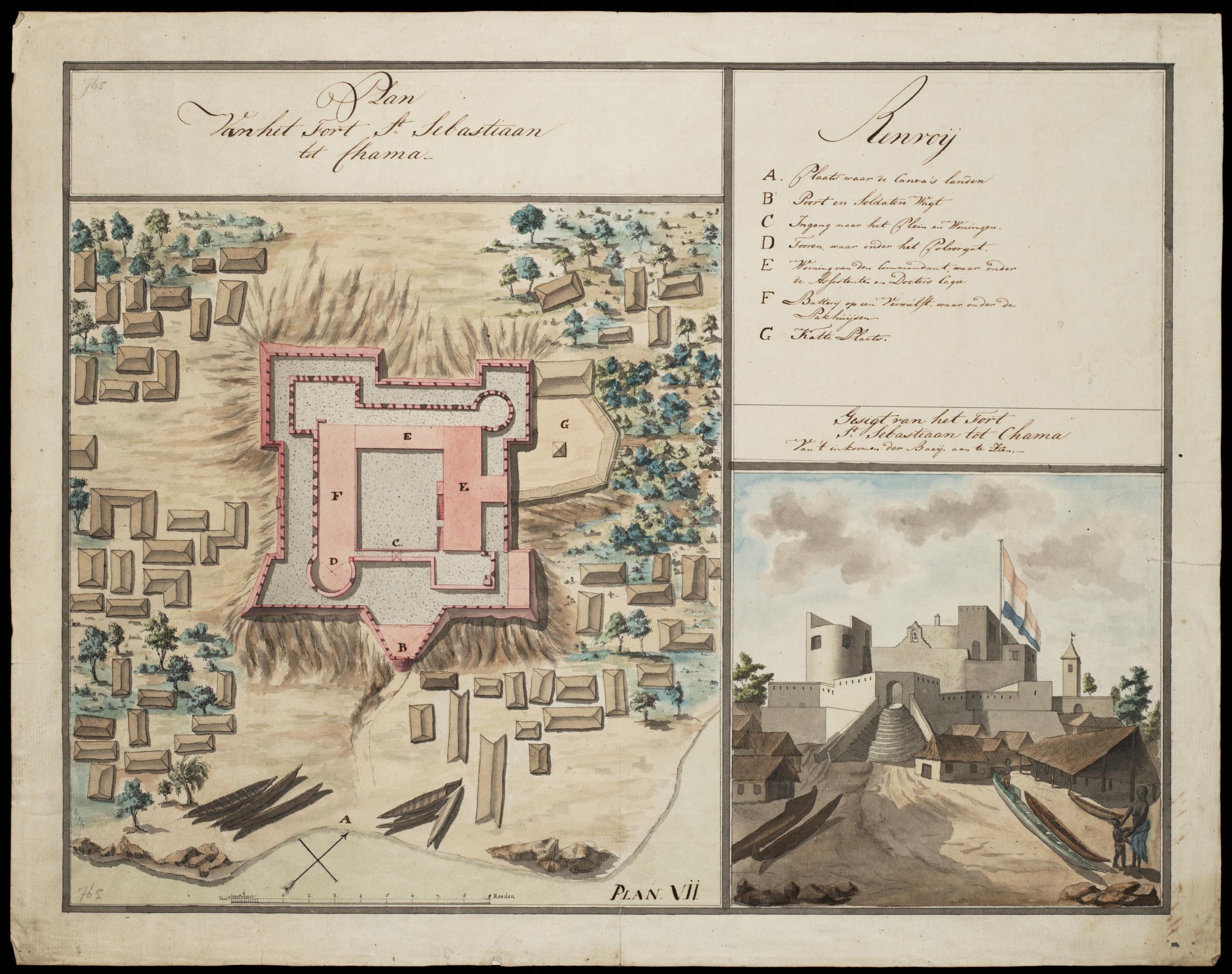
Nederlands: Fort St. Sebastian te Chama
English: Fort St. Sebastian at Chama( |
||||||||||||||||||||||||
|---|---|---|---|---|---|---|---|---|---|---|---|---|---|---|---|---|---|---|---|---|---|---|---|---|
| Author |
Creator:J. W. van Overmeer Fisscher Nederlands: J. W. van Overmeer Fisscher (toegeschreven aan landmeter/kaartenmaker)
English: J. W. van Overmeer Fisscher (assigned to land surveyor / mapmaker) |
|||||||||||||||||||||||
| Title |
Nederlands: Fort St. Sebastian te Chama
English: Fort St. Sebastian at Chama |
|||||||||||||||||||||||
| Description |
Nederlands: Plattegrond van en een gezicht op het fort St. Sebastian te Chama.
Titel catalogus Leupe (NA): Plan Van het Fort St. Sebastiaan tot Chama. Plan Van het Fort St. Sebastiaan tot Chama / Gezigt van het Fort St. Sebastiaan tot Chama / Van 't inkomen der Baaij aan te zien. Legenda: Renvoij / A. Plaats waar de Canoa's landen / B Poort en Soldaten Wagt / C Ingang naar het Plein en Woningen. / D Tooren, waar onder het Polvergat. / E Wooning van den Commandant, waar onder de Assistenten en Doctors Cagie / F Batterij op een Werwulft: waar onder de Pakhuijsen / G Katte Plaats. Notities verso: No. 23 Het Fort St. Sebastiaan. Register 8, Deel 1, Folio 34, Portefeuille .. [geschreven op een blauw etiket] / 463 [met vette cijfers gestempeld op een etiketje]. Rechtsonderin plattegrond: Plan. Vii. Linksboven en linksonder: 765 [in potlood]. In de catalogus Leupe is het aanzicht rechtsonder aangeduid met inventarisnummer VEL0765a.English: Map and view of the St. Sebastian fort at Chama.
Title in the Leupe catalogue (NA): Plan Van het Fort St. Sebastiaan tot Chama. Plan Van het Fort St. Sebastiaan tot Chama / Gezigt van het Fort St. Sebastiaan tot Chama / Van 't inkomen der Baaij aan te zien. Key: Renvoij / A. Plaats waar de Canoa's landen / B Poort en Soldaten Wagt / C Ingang naar het Plein en Woningen. / D Tooren, waar onder het Polvergat. / E Wooning van den Commandant, waar onder de Assistenten en Doctors Cagie / F Batterij op een Werwulft: waar onder de Pakhuijsen / G Katte Plaats. Notes on reverse: No. 23 Het Fort St. Sebastiaan. Register 8, Deel 1, Folio 34, Portefeuille .. [inscribed on a blue label] / 463 [stamped in bold figures on a small label]. At bottom right, a map: Plan. Vii. Top left and bottom left: 765 [in pencil]. In the Leupe catalogue the view bottom right has been assigned the inventory number VEL0765a. |
|||||||||||||||||||||||
| Date | 1786 | |||||||||||||||||||||||
| Medium |
Nederlands: ingekleurde tekening op papier
English: coloured drawing on paper |
|||||||||||||||||||||||
| Dimensions | height: 60 cm (23.6 in); width: 47.5 cm (18.7 in) | |||||||||||||||||||||||
| Collection |
|
|||||||||||||||||||||||
| Accession number |
NL-HaNA_4.VEL_765 (old number: VEL0765) |
|||||||||||||||||||||||
| Inscriptions |
Plan Van het Fort St. Sebastiaan tot Chama / Gezigt van het Fort St. Sebastiaan tot Chama / Van 't inkomen der Baaij aan te zien.
|
|||||||||||||||||||||||
| Notes |
English: Subjects: chart / map / plan, survey / view, key, fortification, building, house, powder magazine / powder mill, tower, Person, Asians & Africans, ship / vessel
Nederlands: Onderwerpen: plattegrond / kaart, overzicht / aanzicht, legenda, vesting, gebouw, huis / woonhuis, kruithuis / kruitmolen, toren, Persoon, Aziaten & Afrikanen, schip / vaartuig
English: Post: this image is related to a WIC trading post called Shama |
|||||||||||||||||||||||
| Source/Photographer |
|
|||||||||||||||||||||||
| Permission (Reusing this file) |
|
|||||||||||||||||||||||

| Object location | | View this and other nearby images on: OpenStreetMap |
|---|
File history
Click on a date/time to view the file as it appeared at that time.
| Date/Time | Thumbnail | Dimensions | User | Comment | |
|---|---|---|---|---|---|
| current | 10:10, 11 June 2014 | | 2,400 × 1,897 (602 KB) | HuskyBot (talk | contribs) | == {{int:filedesc}} == {{Artwork |title = {{nl|1=Fort St. Sebastian te Chama}} {{en|1=Fort St. Sebastian at Chama}} |description = {{nl|1=Plattegrond van en een gezicht op het fort St. Sebastian te Chama. Tite... |
You cannot overwrite this file.
File usage on Commons
The following 2 pages use this file:
File usage on other wikis
The following other wikis use this file:
- Usage on fr.wikipedia.org
- Usage on www.wikidata.org