File:AMH-7320-KB Map of Loanda.jpg
Jump to navigation
Jump to search

Size of this preview: 786 × 600 pixels. Other resolutions: 315 × 240 pixels | 629 × 480 pixels | 1,007 × 768 pixels | 1,280 × 977 pixels | 2,400 × 1,831 pixels.
Original file (2,400 × 1,831 pixels, file size: 723 KB, MIME type: image/jpeg)
Captions
Captions
Add a one-line explanation of what this file represents
Summary[edit]
Nederlands: Plattegrond van Loanda
English: Map of Loanda( |
|||||||||||||||||||||||||||||||||||||||||||||||||||||||||||||||||||||||||||
|---|---|---|---|---|---|---|---|---|---|---|---|---|---|---|---|---|---|---|---|---|---|---|---|---|---|---|---|---|---|---|---|---|---|---|---|---|---|---|---|---|---|---|---|---|---|---|---|---|---|---|---|---|---|---|---|---|---|---|---|---|---|---|---|---|---|---|---|---|---|---|---|---|---|---|---|
| Author |
Nederlands: Georg Marcgraf (toegeschreven aan landmeter/kaartenmaker), Joan Blaeu sr. (uitgever), Frans Post (toegeschreven aan landmeter/kaartenmaker)
English: Georg Marcgraf (assigned to land surveyor / mapmaker), Joan Blaeu sr. (publisher), Frans Post (assigned to land surveyor / mapmaker) |
||||||||||||||||||||||||||||||||||||||||||||||||||||||||||||||||||||||||||
| Title |
Nederlands: Plattegrond van Loanda
English: Map of Loanda |
||||||||||||||||||||||||||||||||||||||||||||||||||||||||||||||||||||||||||
| Description |
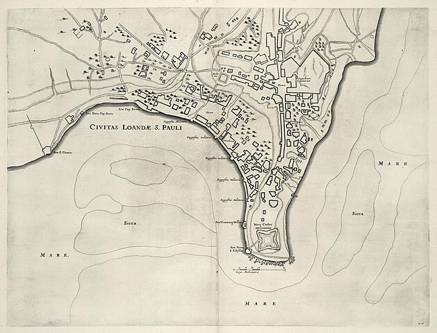
Nederlands: Plattegrond van Loanda.
Civitas Loandae S. Pauli. Rechtsonder: no: 48. Cf. Nationaal Archief, Den Haag, inv. nr. VELH 619.63English: Map of Loanda.
Civitas Loandae S. Pauli. Bottom right: no: 48. Cf. National Archives, The Hague, inv. nr. VELH 619.63 |
||||||||||||||||||||||||||||||||||||||||||||||||||||||||||||||||||||||||||
| Date | 1647 | ||||||||||||||||||||||||||||||||||||||||||||||||||||||||||||||||||||||||||
| Medium |
Nederlands: koperdruk op papier
English: copperplate printing on paper |
||||||||||||||||||||||||||||||||||||||||||||||||||||||||||||||||||||||||||
| Dimensions | height: 53 cm (20.8 in); width: 41 cm (16.1 in) | ||||||||||||||||||||||||||||||||||||||||||||||||||||||||||||||||||||||||||
| Collection |
|
||||||||||||||||||||||||||||||||||||||||||||||||||||||||||||||||||||||||||
| Accession number |
1043 B 14, na p. 204 no. 48 |
||||||||||||||||||||||||||||||||||||||||||||||||||||||||||||||||||||||||||
| Inscriptions |
Civitas Loandae S. Pauli
|
||||||||||||||||||||||||||||||||||||||||||||||||||||||||||||||||||||||||||
| Notes |
English: Subjects: chart / map / plan, fortification, house, fence / kraal, building
Nederlands: Onderwerpen: plattegrond / kaart, vesting, huis / woonhuis, omheining / kraal, gebouw
English: Post: this image is related to a WIC trading post called Luanda |
||||||||||||||||||||||||||||||||||||||||||||||||||||||||||||||||||||||||||
| Source/Photographer |
|
||||||||||||||||||||||||||||||||||||||||||||||||||||||||||||||||||||||||||
| Permission (Reusing this file) |
|
||||||||||||||||||||||||||||||||||||||||||||||||||||||||||||||||||||||||||
.jpg)
.jpg)

| Object location | | View this and other nearby images on: OpenStreetMap |
|---|
File history
Click on a date/time to view the file as it appeared at that time.
| Date/Time | Thumbnail | Dimensions | User | Comment | |
|---|---|---|---|---|---|
| current | 13:00, 10 June 2014 | | 2,400 × 1,831 (723 KB) | HuskyBot (talk | contribs) | == {{int:filedesc}} == {{Artwork |title = {{nl|1=Plattegrond van Loanda}} {{en|1=Map of Loanda}} |description = {{nl|1=Plattegrond van Loanda. ''Civitas Loandae S. Pauli''. Rechtsonder: ''no: 48''. Cf. Natio... |
You cannot overwrite this file.
File usage on Commons
The following page uses this file: