File:AMH-7290-KB Map of Serinhaim.jpg
Jump to navigation
Jump to search
Size of this preview: 783 × 600 pixels. Other resolutions: 313 × 240 pixels | 627 × 480 pixels | 1,002 × 768 pixels | 1,280 × 981 pixels | 2,400 × 1,839 pixels.
Original file (2,400 × 1,839 pixels, file size: 832 KB, MIME type: image/jpeg)
Captions
Captions
Add a one-line explanation of what this file represents
Summary[edit]
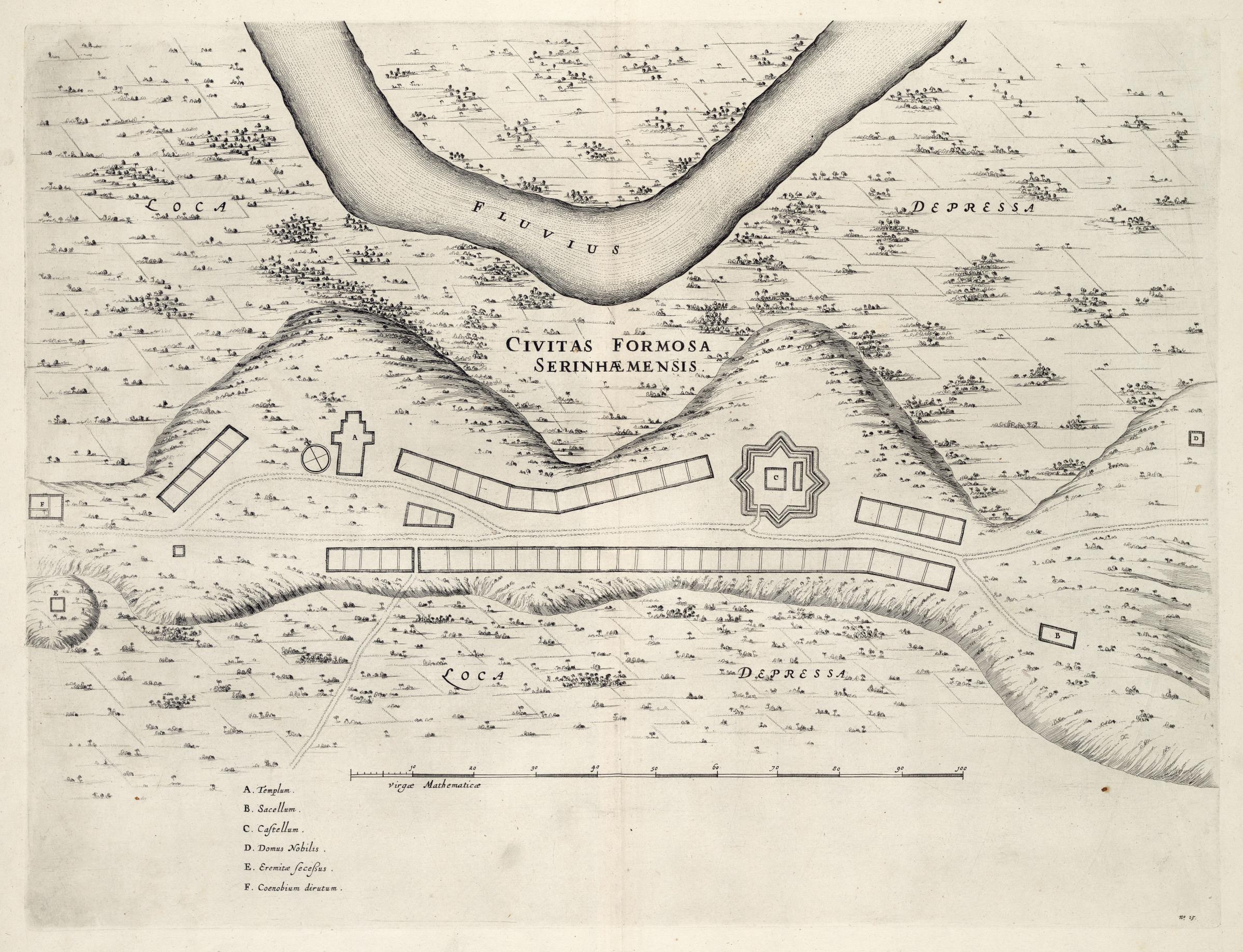
Nederlands: Plattegrond van Serinhaim
English: Map of Serinhaim( |
|||||||||||||||||||||||||||||||||||||||||||||||||||||||||||||||||||||||||||
|---|---|---|---|---|---|---|---|---|---|---|---|---|---|---|---|---|---|---|---|---|---|---|---|---|---|---|---|---|---|---|---|---|---|---|---|---|---|---|---|---|---|---|---|---|---|---|---|---|---|---|---|---|---|---|---|---|---|---|---|---|---|---|---|---|---|---|---|---|---|---|---|---|---|---|---|
| Author |
Nederlands: Georg Marcgraf (toegeschreven aan landmeter/kaartenmaker), Joan Blaeu sr. (uitgever), Frans Post (toegeschreven aan landmeter/kaartenmaker)
English: Georg Marcgraf (assigned to land surveyor / mapmaker), Joan Blaeu sr. (publisher), Frans Post (assigned to land surveyor / mapmaker) |
||||||||||||||||||||||||||||||||||||||||||||||||||||||||||||||||||||||||||
| Title |
Nederlands: Plattegrond van Serinhaim
English: Map of Serinhaim |
||||||||||||||||||||||||||||||||||||||||||||||||||||||||||||||||||||||||||
| Description |
Nederlands: Plattegrond van Serinhaim.
Civitas Formosa Serinhaemensis. Rechtsonder: no: 13. Legenda: A. Templum. / B. Sacellum. / C. Castellum. / D. Domus Nobilis. / E. Eremitae seceßus. / F. Coenobium dirutum.English: Map of Serinhaim.
Civitas Formosa Serinhaemensis. Bottom right: no: 13. Key: A. Templum. / B. Sacellum. / C. Castellum. / D. Domus Nobilis. / E. Eremitae seceßus. / F. Coenobium dirutum. |
||||||||||||||||||||||||||||||||||||||||||||||||||||||||||||||||||||||||||
| Date | 1647 | ||||||||||||||||||||||||||||||||||||||||||||||||||||||||||||||||||||||||||
| Medium |
Nederlands: koperdruk op papier
English: copperplate printing on paper |
||||||||||||||||||||||||||||||||||||||||||||||||||||||||||||||||||||||||||
| Dimensions | height: 53 cm (20.8 in); width: 41 cm (16.1 in) | ||||||||||||||||||||||||||||||||||||||||||||||||||||||||||||||||||||||||||
| Collection |
|
||||||||||||||||||||||||||||||||||||||||||||||||||||||||||||||||||||||||||
| Accession number |
1043 B 14, na p. 40 no. 13 |
||||||||||||||||||||||||||||||||||||||||||||||||||||||||||||||||||||||||||
| Inscriptions |
Civitas Formosa Serinhaemensis
|
||||||||||||||||||||||||||||||||||||||||||||||||||||||||||||||||||||||||||
| Notes |
English: Subjects: monastery / seminary, chart / map / plan, key, church / parsonage, fortification, compass / dial, building
Nederlands: Onderwerpen: klooster / seminarie, plattegrond / kaart, legenda, kerk / pastorie, vesting, kompas / windroos, gebouw
English: Post: this image is related to a WIC trading post called Serinhaem |
||||||||||||||||||||||||||||||||||||||||||||||||||||||||||||||||||||||||||
| Source/Photographer |
|
||||||||||||||||||||||||||||||||||||||||||||||||||||||||||||||||||||||||||
| Permission (Reusing this file) |
|
||||||||||||||||||||||||||||||||||||||||||||||||||||||||||||||||||||||||||
.jpg)
.jpg)

| Object location | | View this and other nearby images on: OpenStreetMap |
|---|
File history
Click on a date/time to view the file as it appeared at that time.
| Date/Time | Thumbnail | Dimensions | User | Comment | |
|---|---|---|---|---|---|
| current | 12:53, 10 June 2014 | | 2,400 × 1,839 (832 KB) | HuskyBot (talk | contribs) | == {{int:filedesc}} == {{Artwork |title = {{nl|1=Plattegrond van Serinhaim}} {{en|1=Map of Serinhaim}} |description = {{nl|1=Plattegrond van Serinhaim. ''Civitas Formosa Serinhaemensis''. Rechtsonder: ''no: 1... |
You cannot overwrite this file.
File usage on Commons
The following page uses this file: