File:AMH-6460-KB Map of the African Gold and Slave coast.jpg
Jump to navigation
Jump to search
Size of this preview: 771 × 599 pixels. Other resolutions: 309 × 240 pixels | 618 × 480 pixels | 988 × 768 pixels | 1,280 × 995 pixels | 2,400 × 1,866 pixels.
Original file (2,400 × 1,866 pixels, file size: 852 KB, MIME type: image/jpeg)
Captions
Captions
Add a one-line explanation of what this file represents
Summary[edit]
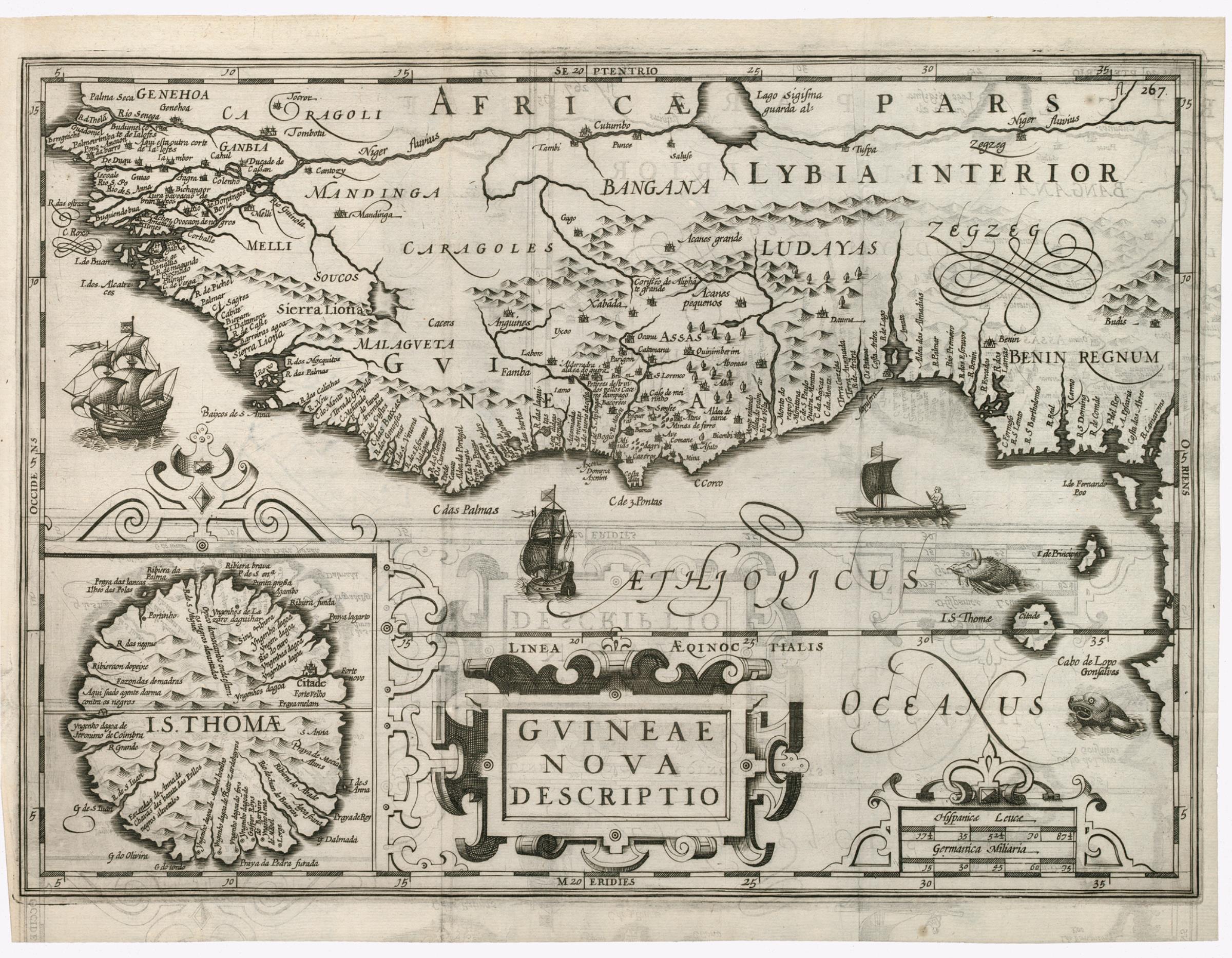
Nederlands: Kaart van de Afrikaanse Goud- en Slavenkust
English: Map of the African Gold and Slave coast( |
|||||||||||||||||||||
|---|---|---|---|---|---|---|---|---|---|---|---|---|---|---|---|---|---|---|---|---|---|
| Author |
Nederlands: Anoniem / Anonymous (graveur / etser)
English: Anoniem / Anonymous (engraver / etcher) |
||||||||||||||||||||
| Title |
Nederlands: Kaart van de Afrikaanse Goud- en Slavenkust
English: Map of the African Gold and Slave coast |
||||||||||||||||||||
| Description |
Nederlands: Kaart van de Afrikaanse Goudkust.
Cartouche: Guinea nova descriptio. Rechtsboven: fl 267. Inzet links onder: Kaart van het eiland Sao Thomé.English: Map of the African Gold Coast.
Cartouche bearing the inscription: Guinea nova descriptio. Top right: fl 267. Inset bottom left: Map of the island of Sao Thomé. |
||||||||||||||||||||
| Date | 1614 | ||||||||||||||||||||
| Medium |
Nederlands: gravure op papier
English: engraving on paper |
||||||||||||||||||||
| Dimensions | height: 26.5 cm (10.4 in); width: 33.5 cm (13.1 in) | ||||||||||||||||||||
| Collection |
|
||||||||||||||||||||
| Accession number |
496 D 12 deel II, na p. 266 |
||||||||||||||||||||
| Inscriptions |
Guinea Nova Descriptio
|
||||||||||||||||||||
| Notes |
English: Subjects: banderole / cartouche / ornamentation, ship / vessel, fauna, chart / map / plan
Nederlands: Onderwerpen: banderol / cartouche / versiering, schip / vaartuig, fauna, plattegrond / kaart
English: Post: this image is related to a WIC trading post called Elmina |
||||||||||||||||||||
| Source/Photographer |
|
||||||||||||||||||||
| Permission (Reusing this file) |
|
||||||||||||||||||||

| Object location | | View this and other nearby images on: OpenStreetMap |
|---|
File history
Click on a date/time to view the file as it appeared at that time.
| Date/Time | Thumbnail | Dimensions | User | Comment | |
|---|---|---|---|---|---|
| current | 11:03, 10 June 2014 | | 2,400 × 1,866 (852 KB) | HuskyBot (talk | contribs) | == {{int:filedesc}} == {{Artwork |title = {{nl|1=Kaart van de Afrikaanse Goud- en Slavenkust}} {{en|1=Map of the African Gold and Slave coast}} |description = {{nl|1=Kaart van de Afrikaanse Goudkust. Cartouche... |
You cannot overwrite this file.
File usage on Commons
The following page uses this file:
File usage on other wikis
The following other wikis use this file:
- Usage on lij.wikipedia.org