File:AMH-5602-NA Coastal map from Saldanha Bay to Mossel Bay.jpg
Jump to navigation
Jump to search

Size of this preview: 700 × 599 pixels. Other resolutions: 280 × 240 pixels | 561 × 480 pixels | 897 × 768 pixels | 1,196 × 1,024 pixels | 2,400 × 2,055 pixels.
Original file (2,400 × 2,055 pixels, file size: 1 MB, MIME type: image/jpeg)
Captions
Captions
Add a one-line explanation of what this file represents
Summary[edit]
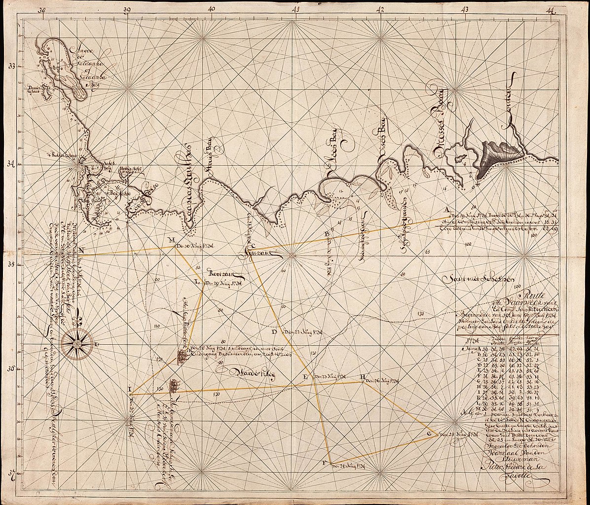
Nederlands: Kaart van de Saldanhabaai tot de Mosselbaai
English: Coastal map from Saldanha Bay to Mossel Bay( |
||||||||||||||||||||||||
|---|---|---|---|---|---|---|---|---|---|---|---|---|---|---|---|---|---|---|---|---|---|---|---|---|
| Author |
Nederlands: Anoniem / Anonymous (landmeter / kaartenmaker)
English: Anoniem / Anonymous (land surveyor / mapmaker) |
|||||||||||||||||||||||
| Title |
Nederlands: Kaart van de Saldanhabaai tot de Mosselbaai
English: Coastal map from Saldanha Bay to Mossel Bay |
|||||||||||||||||||||||
| Description |
Nederlands: Titel catalogus Leupe (NA): Route ofte vaarwech van 't Ed. Comp. schip Ridderkerk beginnende van 19 Junij tot primo Julij 1734, wanneer het land ontdekte volgens de peijling aen Baij Fals en d'Houtbaij.
Bijzonderheden: de kompaslijnen zijn gedrukt. [Ingevolge het gehouden journaal van den stuurman Pieter Theodore de la Fayolle, 1735].English: Title in the Leupe catalogue (NA): Route ofte vaarwech van 't Ed. Comp. schip Ridderkerk beginnende van 19 Junij tot primo Julij 1734, wanneer het land ontdekte volgens de peijling aen Baij Fals en d'Houtbaij.
Particulars: the compass lines have been printed. [In accordance with the journal kept by helmsman Pieter Theodore de la Fayolle, 1735]. |
|||||||||||||||||||||||
| Date | 1734 | |||||||||||||||||||||||
| Medium |
Nederlands: ingekleurde tekening op papier
English: coloured drawing on paper |
|||||||||||||||||||||||
| Dimensions | height: 61 cm (24 in); width: 53 cm (20.8 in) | |||||||||||||||||||||||
| Collection |
|
|||||||||||||||||||||||
| Accession number |
NL-HaNA_4.VELH_101 (old number: VELH0101) |
|||||||||||||||||||||||
| Inscriptions |
-
|
|||||||||||||||||||||||
| Notes |
English: Subjects: chart / map / plan, ship / vessel, expedition
Nederlands: Onderwerpen: plattegrond / kaart, schip / vaartuig, expeditie
English: Post: this image is related to a VOC trading post called Cape Town |
|||||||||||||||||||||||
| Source/Photographer |
|
|||||||||||||||||||||||
| Permission (Reusing this file) |
|
|||||||||||||||||||||||

| Object location | | View this and other nearby images on: OpenStreetMap |
|---|
File history
Click on a date/time to view the file as it appeared at that time.
| Date/Time | Thumbnail | Dimensions | User | Comment | |
|---|---|---|---|---|---|
| current | 08:40, 11 June 2014 | | 2,400 × 2,055 (1 MB) | HuskyBot (talk | contribs) | == {{int:filedesc}} == {{Artwork |title = {{nl|1=Kaart van de Saldanhabaai tot de Mosselbaai}} {{en|1=Coastal map from Saldanha Bay to Mossel Bay}} |description = {{nl|1=Titel catalogus Leupe (NA): ''Route ofte... |
You cannot overwrite this file.
File usage on Commons
The following page uses this file: