File:AMH-5334-NA Sketch of the Chavonnes battery.jpg
Jump to navigation
Jump to search

Size of this preview: 800 × 583 pixels. Other resolutions: 320 × 233 pixels | 640 × 466 pixels | 1,024 × 746 pixels | 1,280 × 932 pixels | 2,560 × 1,865 pixels | 7,195 × 5,241 pixels.
Original file (7,195 × 5,241 pixels, file size: 5.36 MB, MIME type: image/jpeg)
Captions
Captions
Add a one-line explanation of what this file represents
Summary[edit]
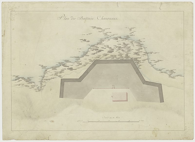
Nederlands: Tekening van Batterie Chavonnes
English: Sketch of the Chavonnes battery( |
||||||||||||||||||||||||
|---|---|---|---|---|---|---|---|---|---|---|---|---|---|---|---|---|---|---|---|---|---|---|---|---|
| Author |
Nederlands: Anoniem / Anonymous (landmeter / kaartenmaker)
English: Anoniem / Anonymous (land surveyor / mapmaker) |
|||||||||||||||||||||||
| Title |
Nederlands: Tekening van Batterie Chavonnes
English: Sketch of the Chavonnes battery |
|||||||||||||||||||||||
| Description |
Nederlands: Titel catalogus Leupe (NA): Plan der Batterie Chavonnes].
Notities verso: No. 9 Batterij Chavonnes, Register 10, Deel 1, Folio 40, Portefeuille … [geschreven op een blauw etiket] / 493 [met vette cijfers gestempeld op een etiketje] / no. 212 / 5 c. [onder elkaar geschreven].
English: Title in the Leupe catalogue (National Archives): Plan der Batterie Chavonnes].
Notes on reverse: No. 9 Batterij Chavonnes, Register 10, Deel 1, Folio 40, Portefeuille … [written on a blue label] / 493 [in bold figures stamped on a small label] / no. 212 / 5 c. [written one below the other]. |
|||||||||||||||||||||||
| Date | between 1700 and 1800 | |||||||||||||||||||||||
| Medium |
Nederlands: pen op papier
English: pen on paper |
|||||||||||||||||||||||
| Dimensions | height: 60 cm (23.6 in); width: 43 cm (16.9 in) | |||||||||||||||||||||||
| Collection |
|
|||||||||||||||||||||||
| Accession number |
NL-HaNA_4.VEL_840 (old number: VEL0840) |
|||||||||||||||||||||||
| Inscriptions |
Plan der Batterie Chavonnes
|
|||||||||||||||||||||||
| Notes |
English: Subjects: building, fortification, survey / view, cross-section / profile
Nederlands: Onderwerpen: gebouw, vesting, overzicht / aanzicht, doorsnede / profiel
English: Fort: this image is related to a VOC fort called fort Chavonis |
|||||||||||||||||||||||
| Source/Photographer |
|
|||||||||||||||||||||||
| Permission (Reusing this file) |
|
|||||||||||||||||||||||

| Object location | | View this and other nearby images on: OpenStreetMap |
|---|
File history
Click on a date/time to view the file as it appeared at that time.
| Date/Time | Thumbnail | Dimensions | User | Comment | |
|---|---|---|---|---|---|
| current | 10:27, 16 May 2017 | | 7,195 × 5,241 (5.36 MB) | Timmietovenaar (talk | contribs) | Higher Resolution |
| 18:02, 10 June 2014 |  | 2,400 × 1,721 (476 KB) | HuskyBot (talk | contribs) | == {{int:filedesc}} == {{Artwork |title = {{nl|1=Tekening van Batterie Chavonnes}} {{en|1=Sketch of the Chavonnes battery}} |description = {{nl|1=Titel catalogus Leupe (NA): ''Plan der Batterie Chavonnes]. Not... |
You cannot overwrite this file.
File usage on Commons
The following page uses this file:
File usage on other wikis
The following other wikis use this file:
- Usage on en.wikipedia.org