File:AMH-4513-NA Map of the fort at Trinconomale.jpg

Original file (2,400 × 2,398 pixels, file size: 703 KB, MIME type: image/jpeg)
Captions
Captions
Summary[edit]
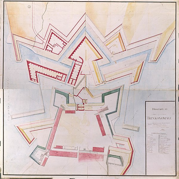
Nederlands: Plattegrond van het fort te Trinconomale
English: Map of the fort at Trinconomale( |
||||||||||||||||||||||||
|---|---|---|---|---|---|---|---|---|---|---|---|---|---|---|---|---|---|---|---|---|---|---|---|---|
| Author |
Nederlands: I.O. Vaillant (opdrachtgever), C.A. Verhuell (opdrachtgever), J.F.L van Gravestein (opdrachtgever), D. Matthysz. (landmeter / kaartenmaker)
English: I.O. Vaillant (patron), C.A. Verhuell (patron), J.F.L van Gravestein (patron), D. Matthysz. (land surveyor / mapmaker) |
|||||||||||||||||||||||
| Title |
Nederlands: Plattegrond van het fort te Trinconomale
English: Map of the fort at Trinconomale |
|||||||||||||||||||||||
| Description |
Nederlands: Titel catalogus Leupe (NA): Hoofdplan van een project tot verbetering der vestingwerken van Trinkonomale, beraamd door de H.H. Vaillant, VerHuell en Graevesteyn, Commissarissen-Militair enz..
Aantekening catalogus Leupe: Behoort bij de rapporten van de militaire commissie naar de Oost 1789-1792. o.l.v. J.O. Vaillant; C.A. Verhuell en J.F.L. van Gravenstein. Zie NA Staatssecretarie inv. nr. 1910-1932; Collectie Verhuell nrs. 7-45. Notities verso: [Blauw etiket ODG] nr: 33A Verbetering van Troinconomale. [Gedrukt etiket] nr.: 558. Kopie-plankaart van de nieuwe vestingwerken, kazematten en ravelijnen. Legenda: A-Y; AA-RR; A-HEnglish: According to the Leupe catalogue (NA), the original title reads: Hoofdplan van een project tot verbetering der vestingwerken van Trinkonomale, beraamd door de H.H. Vaillant, VerHuell en Graevesteyn, Commissarissen-Militair enz..
Notes in the Leupe catalogue: Behoort bij de rapporten van de militaire commissie naar de Oost 1789-1792. o.l.v. J.O. Vaillant; C.A. Verhuell en J.F.L. van Gravenstein. Zie NA Staatssecretarie inv. nr. 1910-1932; Collectie Verhuell nrs. 7-45. Notes on reverse: [Blue label ODG] nr: 33A Verbetering van Troinconomale. [Printed label] nr.: 558. Copy of a planning chart showing the new fortifications, casemates and ravelins. Key: A-Y; AA-RR; A-H. |
|||||||||||||||||||||||
| Date | circa 1750 | |||||||||||||||||||||||
| Medium |
Nederlands: ingekleurde tekening op papier
English: coloured drawing on paper |
|||||||||||||||||||||||
| Dimensions | height: 146 cm (57.4 in); width: 150 cm (59 in) | |||||||||||||||||||||||
| Collection |
|
|||||||||||||||||||||||
| Accession number |
NL-HaNA_4.VEL_1021 (old number: VEL1021) |
|||||||||||||||||||||||
| Inscriptions |
Hoofdplan van een project tot verbeetering der vestingwerken van Trinkonomale [enz]
author: D. Matthysz. |
|||||||||||||||||||||||
| Notes |
English: Subjects: key, banderole / cartouche / ornamentation, chart / map / plan, fortification
Nederlands: Onderwerpen: legenda, banderol / cartouche / versiering, plattegrond / kaart, vesting
English: Post: this image is related to a VOC trading post called Trincomalee |
|||||||||||||||||||||||
| Source/Photographer |
|
|||||||||||||||||||||||
| Permission (Reusing this file) |
|
|||||||||||||||||||||||

| Object location | | View this and other nearby images on: OpenStreetMap |
|---|
File history
Click on a date/time to view the file as it appeared at that time.
| Date/Time | Thumbnail | Dimensions | User | Comment | |
|---|---|---|---|---|---|
| current | 16:28, 10 June 2014 | | 2,400 × 2,398 (703 KB) | HuskyBot (talk | contribs) | == {{int:filedesc}} == {{Artwork |title = {{nl|1=Plattegrond van het fort te Trinconomale}} {{en|1=Map of the fort at Trinconomale}} |description = {{nl|1=Titel catalogus Leupe (NA): ''Hoofdplan van een project... |
You cannot overwrite this file.
File usage on Commons
The following page uses this file: