File:AMH-2640-NA Map of the castle and the city of Colombo.jpg
Original file (2,061 × 2,400 pixels, file size: 573 KB, MIME type: image/jpeg)
Captions
Captions
Summary[edit]
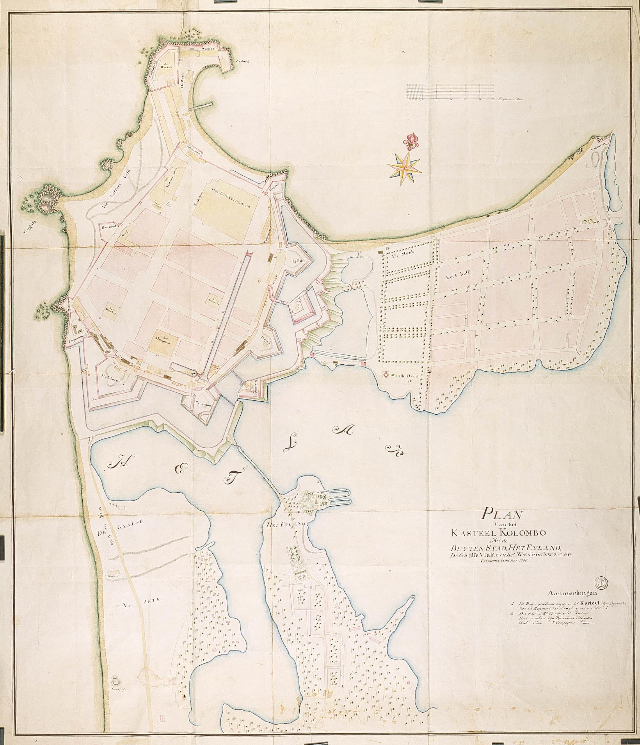
Nederlands: Plattegrond van het kasteel en de stad Colombo
English: Map of the castle and the city of Colombo( |
||||||||||||||||||||||||
|---|---|---|---|---|---|---|---|---|---|---|---|---|---|---|---|---|---|---|---|---|---|---|---|---|
| Author |
Nederlands: Anoniem / Anonymous
English: Anoniem / Anonymous |
|||||||||||||||||||||||
| Title |
Nederlands: Plattegrond van het kasteel en de stad Colombo
English: Map of the castle and the city of Colombo |
|||||||||||||||||||||||
| Description |
Nederlands: Titel catalogus Leupe (NA): Plan van het Kasteel Kolombo, met de buytenstad, het Eyland, de Gaalsche Vlakte en het Wassers Kwartier, opgenomen in het jaar 1786.
Met bruin aangegeven het logement van het regiment van Luxaburg. Notities verso: Nr. 18; [Blauw etiket ODG] Plan en situatie van het Kasteel Colombo met de buitenstad. [Etiket gedrukt] nr. 523. Legenda: A-B Topografische namen vermeld op deze kaart: Colombo, Batenburg, den Briel, Enckhuysen, Middelburgh, Rotterdam, Hoorn, Amsterdam, Delvt, Leyden, Zeeburg, Klippenburgh, Victoria.English: According to the Leupe catalogue (NA), the original title reads: Plan van het Kasteel Kolombo, met de buytenstad, het Eyland, de Gaalsche Vlakte en het Wassers Kwartier, opgenomen in het jaar 1786.
The lodgings of the regiment of Luxaburg are indicated in brown. Notes on reverse: Nr. 18; [Blue label ODG] Plan en situatie van het Kasteel Colombo met de buitenstad. [Printed label] nr. 523. Key: A-B Topographical names mentioned: Colombo, Batenburg, den Briel, Enckhuysen, Middelburgh, Rotterdam, Hoorn, Amsterdam, Delvt, Leyden, Zeeburg, Klippenburgh, Victoria. |
|||||||||||||||||||||||
| Date | 1786 | |||||||||||||||||||||||
| Medium |
Nederlands: ingekleurde tekening op papier
English: coloured drawing on paper |
|||||||||||||||||||||||
| Dimensions | height: 115 cm (45.2 in); width: 134 cm (52.7 in) | |||||||||||||||||||||||
| Collection |
|
|||||||||||||||||||||||
| Accession number |
NL-HaNA_4.VEL_958 (old number: VEL0958) |
|||||||||||||||||||||||
| Inscriptions |
Plan van het Kasteel Kolombo, Met de Buytenstad, Het Eyland, de Gaalse Vlakte en het Wassers Kwartier, opgenomen in het jaar 1786
|
|||||||||||||||||||||||
| Notes |
English: Subjects: chart / map / plan, fortification, hospital / lazaret, cemetery / graveyard, church / parsonage, orphanage, compass / dial, powder magazine / powder mill, assembly hall / town hall, key
Nederlands: Onderwerpen: plattegrond / kaart, vesting, ziekenhuis / lazaret, begraafplaats / kerkhof, kerk / pastorie, weeshuis, kompas / windroos, kruithuis / kruitmolen, raadhuis / stadhuis, legenda
English: Fort: this image is related to a VOC fort called kasteel Colombo |
|||||||||||||||||||||||
| Source/Photographer |
|
|||||||||||||||||||||||
| Permission (Reusing this file) |
|
|||||||||||||||||||||||

| Object location | | View this and other nearby images on: OpenStreetMap |
|---|
File history
Click on a date/time to view the file as it appeared at that time.
| Date/Time | Thumbnail | Dimensions | User | Comment | |
|---|---|---|---|---|---|
| current | 16:13, 10 June 2014 | | 2,061 × 2,400 (573 KB) | HuskyBot (talk | contribs) | == {{int:filedesc}} == {{Artwork |title = {{nl|1=Plattegrond van het kasteel en de stad Colombo}} {{en|1=Map of the castle and the city of Colombo}} |description = {{nl|1=Titel catalogus Leupe (NA): ''Plan van... |
You cannot overwrite this file.
File usage on Commons
The following page uses this file:
File usage on other wikis
The following other wikis use this file:
- Usage on fr.wikipedia.org