File:AMH-2618-NA The Castle and the city of Colombo and environs.jpg

Original file (2,400 × 1,158 pixels, file size: 420 KB, MIME type: image/jpeg)
Captions
Captions
Summary[edit]
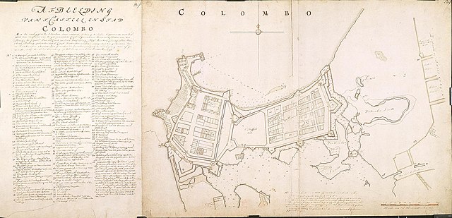
Nederlands: Het kasteel en de stad Colombo met omstreken
English: The Castle and the city of Colombo and environs( |
||||||||||||||||||||||||||
|---|---|---|---|---|---|---|---|---|---|---|---|---|---|---|---|---|---|---|---|---|---|---|---|---|---|---|
| Author |
Nederlands: Isaac de Graaff (landmeter / kaartenmaker), Livinius Stevenz (landmeter / kaartenmaker)
English: Isaac de Graaff (land surveyor / mapmaker), Livinius Stevenz (land surveyor / mapmaker) |
|||||||||||||||||||||||||
| Title |
Nederlands: Het kasteel en de stad Colombo met omstreken
English: The Castle and the city of Colombo and environs |
|||||||||||||||||||||||||
| Description |
Nederlands: Titel catalogus Leupe (NA): Situatie van 't Casteel, de Stadt Columbo en omstreken.
Legenda: 1-111 Notities verso: A. A. 23f. Verso nr. 542d; met potlood: 38; 22 doorgehaald. Rechtsboven: 23 f. Topografische namen vermeld op deze kaart: punt den Briel, punt Enckhuysen, punt Middelburgh, punt Rotterdam, punt Hoorn, punt Amsterdam, punt Delft, punt Leiden, Schiedam, Dorth, punt Haarlem, punt Concordia, punt constantia, punt Victoria.English: The original title according to the catalogue Leupe (NA) reads: Situatie van 't Casteel, de Stadt Columbo en omstreken.
Key: 1-111 Notes on reverse: A. A. 23f. Verso nr. 542d; met potlood: 38; 22 doorgehaald. Upper right: 23 f. Mention is made of the following topographical names: punt den Briel, punt Enckhuysen, punt Middelburgh, punt Rotterdam, punt Hoorn, punt Amsterdam, punt Delft, punt Leiden, Schiedam, Dorth, punt Haarlem, punt Concordia, punt constantia, punt Victoria. |
|||||||||||||||||||||||||
| Date | between 1690 and 1743 | |||||||||||||||||||||||||
| Medium |
Nederlands: ingekleurde tekening op papier
English: coloured drawing on paper |
|||||||||||||||||||||||||
| Dimensions | height: 106.1 cm (41.7 in); width: 51 cm (20 in) | |||||||||||||||||||||||||
| Collection |
|
|||||||||||||||||||||||||
| Accession number |
NL-HaNA_4.VEL_944 (old number: VEL0944) |
|||||||||||||||||||||||||
| Inscriptions |
Afbeelding van 't Casteel en stad Colombo / Met de omleggende situatien daar omtrent, sodanig de selve, beginnende met Feb. 1681 ten overstaan van de gecommitteerde Coopl: Egmont van Sterreveld, Wouter van der Beeq; de Capt: Jan del Court en Jacob Wetsenburg, Luit: Hendrik Coning, Jan Martenz Helling opsiender van 's Comp:s Fortificatie werken: mitsgaders den geswooren Roi en Landmeeter Stevenz sijn gemeeten en bevonden, volgens de beschrijving daar af gemaakt, en bij derselve bevinding op 25 Juny met haar handteekeningh. |
|||||||||||||||||||||||||
| Notes |
English: Subjects: chart / map / plan, church / parsonage, fortification, house, hospital / lazaret, cemetery / graveyard, school, garden / ornamental garden, warehouse, shipyard, orphanage, prison, menagerie / stable, key, compass / dial
Nederlands: Onderwerpen: plattegrond / kaart, kerk / pastorie, vesting, huis / woonhuis, ziekenhuis / lazaret, begraafplaats / kerkhof, school, tuin / siertuin, pakhuis, scheeps- / timmerwerf, weeshuis, gevangenis, menagerie / stal, legenda, kompas / windroos
English: Fort: this image is related to a VOC fort called kasteel Colombo |
|||||||||||||||||||||||||
| Source/Photographer |
|
|||||||||||||||||||||||||
| Permission (Reusing this file) |
|
|||||||||||||||||||||||||

| Object location | | View this and other nearby images on: OpenStreetMap |
|---|
File history
Click on a date/time to view the file as it appeared at that time.
| Date/Time | Thumbnail | Dimensions | User | Comment | |
|---|---|---|---|---|---|
| current | 16:09, 10 June 2014 | | 2,400 × 1,158 (420 KB) | HuskyBot (talk | contribs) | == {{int:filedesc}} == {{Artwork |title = {{nl|1=Het kasteel en de stad Colombo met omstreken}} {{en|1=The Castle and the city of Colombo and environs}} |description = {{nl|1=Titel catalogus Leupe (NA): ''Situa... |
You cannot overwrite this file.
File usage on Commons
The following page uses this file: