File:AMH-2523-NA Map of the island of Mauritius.jpg
Jump to navigation
Jump to search

Size of this preview: 800 × 591 pixels. Other resolutions: 320 × 236 pixels | 640 × 473 pixels | 1,024 × 756 pixels | 1,280 × 946 pixels | 2,400 × 1,773 pixels.
Original file (2,400 × 1,773 pixels, file size: 572 KB, MIME type: image/jpeg)
Captions
Captions
Add a one-line explanation of what this file represents
Summary[edit]
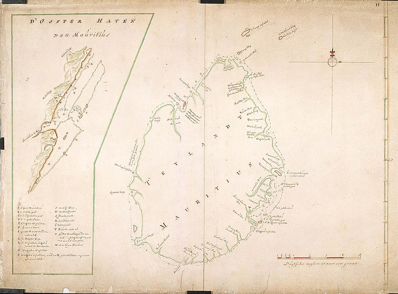
Nederlands: Kaart van het eiland Mauritius
English: Map of the island of Mauritius( |
||||||||||||||||||||||||||
|---|---|---|---|---|---|---|---|---|---|---|---|---|---|---|---|---|---|---|---|---|---|---|---|---|---|---|
| Author |
Nederlands: Anoniem / Anonymous (landmeter / kaartenmaker), Isaac de Graaff
English: Anoniem / Anonymous (land surveyor / mapmaker), Isaac de Graaff |
|||||||||||||||||||||||||
| Title |
Nederlands: Kaart van het eiland Mauritius
English: Map of the island of Mauritius |
|||||||||||||||||||||||||
| Description |
Nederlands: Titel catalogus Leupe (NA): Kaart van 't Eyland Mauritius.
Legenda: A-W
English: According to the Leupe catalogue (NA) the original title reads: Kaart van 't Eyland Mauritius.
Key: A-W |
|||||||||||||||||||||||||
| Date | between 1600 and 1700 | |||||||||||||||||||||||||
| Medium |
Nederlands: ingekleurde tekening op papier
English: coloured drawing on paper |
|||||||||||||||||||||||||
| Dimensions | height: 735 mm (28.93 in); width: 530 mm (20.86 in) | |||||||||||||||||||||||||
| Collection |
|
|||||||||||||||||||||||||
| Accession number |
NL-HaNA_4.VEL_334 (old number: VEL0334) |
|||||||||||||||||||||||||
| Inscriptions |
D' Ooster Haven van Mauritius / T' Eylandt Mauritius
|
|||||||||||||||||||||||||
| Notes |
English: Subjects: chart / map / plan, church / parsonage, fortification, anchorage / pier / harbour, shipyard, compass / dial
Nederlands: Onderwerpen: plattegrond / kaart, kerk / pastorie, vesting, rede / haven / pier, scheeps- / timmerwerf, kompas / windroos
English: Fort: this image is related to a VOC fort called fort Mauritius Frederik Hendrik |
|||||||||||||||||||||||||
| Source/Photographer |
|
|||||||||||||||||||||||||
| Permission (Reusing this file) |
|
|||||||||||||||||||||||||

| Object location | | View this and other nearby images on: OpenStreetMap |
|---|
File history
Click on a date/time to view the file as it appeared at that time.
| Date/Time | Thumbnail | Dimensions | User | Comment | |
|---|---|---|---|---|---|
| current | 15:51, 10 June 2014 | | 2,400 × 1,773 (572 KB) | HuskyBot (talk | contribs) | == {{int:filedesc}} == {{Artwork |title = {{nl|1=Kaart van het eiland Mauritius}} {{en|1=Map of the island of Mauritius}} |description = {{nl|1=Titel catalogus Leupe (NA): ''Kaart van 't Eyland Mauritius''. Le... |
You cannot overwrite this file.
File usage on Commons
The following page uses this file:
File usage on other wikis
The following other wikis use this file:
- Usage on nl.wikipedia.org