File:AMH-2522-NA Map of the island of Mauritius.jpg
Jump to navigation
Jump to search

Size of this preview: 389 × 600 pixels. Other resolutions: 156 × 240 pixels | 311 × 480 pixels | 498 × 768 pixels | 664 × 1,024 pixels | 1,557 × 2,400 pixels.
Original file (1,557 × 2,400 pixels, file size: 582 KB, MIME type: image/jpeg)
Captions
Captions
Add a one-line explanation of what this file represents
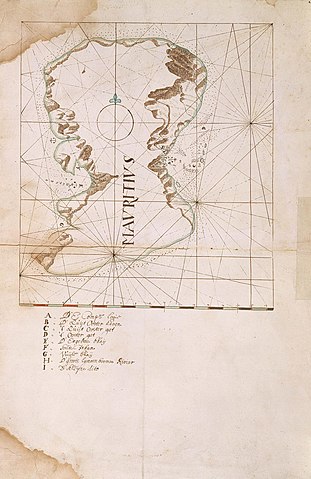
Summary[edit]
Nederlands: Kaart van het eiland Mauritius
English: Map of the island of Mauritius( |
||||||||||||||||||||||||
|---|---|---|---|---|---|---|---|---|---|---|---|---|---|---|---|---|---|---|---|---|---|---|---|---|
| Author |
Nederlands: Anoniem / Anonymous
English: Anoniem / Anonymous |
|||||||||||||||||||||||
| Title |
Nederlands: Kaart van het eiland Mauritius
English: Map of the island of Mauritius |
|||||||||||||||||||||||
| Description |
Nederlands: Titel catalogus Leupe (NA): Kaart van het Eylandt Mauritius.
Legenda: A-I Notities verso: Behoort tot de overgekomen brieven en papieren van de Kaap 1666 No 14.English: According to the Leupe catalogue (NA), the original title reads: Kaart van het Eylandt Mauritius.
Key: A-I Notes on reverse: Behoort tot de overgekomen brieven en papieren van de Kaap 1666 No 14. |
|||||||||||||||||||||||
| Date | circa 1666 | |||||||||||||||||||||||
| Medium |
Nederlands: ingekleurde tekening op papier
English: coloured drawing on paper |
|||||||||||||||||||||||
| Dimensions | height: 405 mm (15.94 in); width: 505 mm (19.88 in) | |||||||||||||||||||||||
| Collection |
|
|||||||||||||||||||||||
| Accession number |
NL-HaNA_4.VEL_332 (old number: VEL0332) |
|||||||||||||||||||||||
| Inscriptions |
Mauritius
|
|||||||||||||||||||||||
| Notes |
English: Subjects: chart / map / plan, bird's-eye view / elevation, elevation / bird's-eye view, anchorage / pier / harbour, compass / dial, key
Nederlands: Onderwerpen: plattegrond / kaart, vogelvlucht / opstand, opstand / vogelvlucht, rede / haven / pier, kompas / windroos, legenda
English: Fort: this image is related to a VOC fort called fort Mauritius Frederik Hendrik |
|||||||||||||||||||||||
| Source/Photographer |
|
|||||||||||||||||||||||
| Permission (Reusing this file) |
|
|||||||||||||||||||||||

| Object location | | View this and other nearby images on: OpenStreetMap |
|---|
File history
Click on a date/time to view the file as it appeared at that time.
| Date/Time | Thumbnail | Dimensions | User | Comment | |
|---|---|---|---|---|---|
| current | 15:51, 10 June 2014 | | 1,557 × 2,400 (582 KB) | HuskyBot (talk | contribs) | == {{int:filedesc}} == {{Artwork |title = {{nl|1=Kaart van het eiland Mauritius}} {{en|1=Map of the island of Mauritius}} |description = {{nl|1=Titel catalogus Leupe (NA): ''Kaart van het Eylandt Mauritius''.... |
You cannot overwrite this file.
File usage on Commons
The following page uses this file: