File:AMH-2480-NA Plan for the enlargement of the Fort of Good Hope.jpg

Original file (1,951 × 2,400 pixels, file size: 467 KB, MIME type: image/jpeg)
Captions
Captions
Summary[edit]
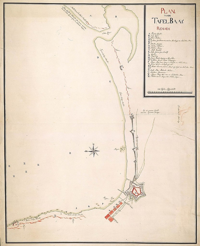
Nederlands: Plan voor de versterking van fort de Goede Hoop
English: Plan for the enlargement of the Fort of Good Hope( |
||||||||||||||||||||||||
|---|---|---|---|---|---|---|---|---|---|---|---|---|---|---|---|---|---|---|---|---|---|---|---|---|
| Author |
Nederlands: Anoniem / Anonymous
English: Anoniem / Anonymous |
|||||||||||||||||||||||
| Title |
Nederlands: Plan voor de versterking van fort de Goede Hoop
English: Plan for the enlargement of the Fort of Good Hope |
|||||||||||||||||||||||
| Description |
Nederlands: Titel catalogus Leupe (NA): Plan als voren, hier wordt bedoeld de titel van VEL0832: Plan ter versterking van het fortres de Goede Hoop.
Opmerking NA: Kaart van de Tafelbaai, van het Paardeneiland tot de batterij Chavonnes, waarop de vestingwerken en de aan te leggen gracht met ophaalbruggen van de Windberg naar de baai staan aangegeven. Notities verso: Blauw etiket Depot-Generaal Nr. 4 Plan van de Tafelbaij; Register 10; deel 1; Folio 39. Legenda: A-Z Topografische namen en batterijen vermeld op deze kaart: Fort de Knokke, Batterie Tulbach, Batterie helena, Batterie Elisabeth, Batterie Couvre façe Inhoff, castel, Batterie S Heer Hendriks Kinderen, Batterie Chavonnes, Tafel Baay.English: The original title according to the catalogue Leupe (NA) reads: Plan als voren, referred to as VE0832: Plan ter versterking van het fortres de Goede Hoop.
Additional comments (NA): Kaart van de Tafelbaai, van het Paardeneiland tot de batterij Chavonnes, waarop de vestingwerken en de aan te leggen gracht met ophaalbruggen van de Windberg naar de baai staan aangegeven. Notes on the reverse: Blauw etiket Depot-Generaal Nr. 4 Plan van de Tafelbaij; Register 10; deel 1; Folio 39. Key: A-Z Topographical names and fortifications mentioned on this map are: Fort de Knokke, Batterie Tulbach, Batterie helena, Batterie Elisabeth, Batterie Couvre façe Inhoff, castel, Batterie S Heer Hendriks Kinderen, Batterie Chavonnes, Tafel Baay. |
|||||||||||||||||||||||
| Date | between 1700 and 1800 | |||||||||||||||||||||||
| Medium |
Nederlands: ingekleurde tekening op papier
English: coloured drawing on paper |
|||||||||||||||||||||||
| Dimensions | height: 75 cm (29.5 in); width: 61 cm (24 in) | |||||||||||||||||||||||
| Collection |
|
|||||||||||||||||||||||
| Accession number |
NL-HaNA_4.VEL_833 (old number: VEL0833) |
|||||||||||||||||||||||
| Inscriptions |
Plan van de Tafel-Baay. Renvoy.
|
|||||||||||||||||||||||
| Notes |
English: Subjects: chart / map / plan, fortification, building, anchorage / pier / harbour, key, compass / dial, banderole / cartouche / ornamentation
Nederlands: Onderwerpen: plattegrond / kaart, vesting, gebouw, rede / haven / pier, legenda, kompas / windroos, banderol / cartouche / versiering
English: Fort: this image is related to a VOC fort called kasteel de Goede Hoop |
|||||||||||||||||||||||
| Source/Photographer |
|
|||||||||||||||||||||||
| Permission (Reusing this file) |
|
|||||||||||||||||||||||

| Object location | | View this and other nearby images on: OpenStreetMap |
|---|
File history
Click on a date/time to view the file as it appeared at that time.
| Date/Time | Thumbnail | Dimensions | User | Comment | |
|---|---|---|---|---|---|
| current | 15:42, 10 June 2014 | | 1,951 × 2,400 (467 KB) | HuskyBot (talk | contribs) | == {{int:filedesc}} == {{Artwork |title = {{nl|1=Plan voor de versterking van fort de Goede Hoop}} {{en|1=Plan for the enlargement of the Fort of Good Hope}} |description = {{nl|1=Titel catalogus Leupe (NA): ''... |
You cannot overwrite this file.
File usage on Commons
The following page uses this file: