File:AMERICÆ PARS MERIDIONALIS - Jan Jansson, 1641-1680 - BL Maps K.Top.124.2 (BLL01018555605).jpg

Original file (6,873 × 5,816 pixels, file size: 6.05 MB, MIME type: image/jpeg)
Captions
Captions
| Title |
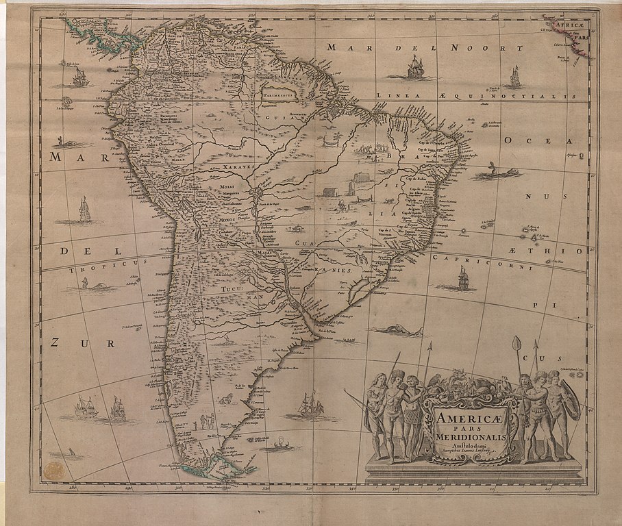
Latina: AMERICÆ PARS MERIDIONALIS. |
|||||||||||||||||||||||||
| Description |
English: Blank at the back, state unrecorded by P. Krogt. Dated in line with editions of J. Jansson's atlases. Dated [1650?] in a previous catalogue. Includes a decorative title cartouche. Includes engravings of indigenous people and fauna. Includes towns, rivers and mountain ranges. Relief shown pictorially. |
|||||||||||||||||||||||||
| Date | [1641-1680] | |||||||||||||||||||||||||
| Source |
Part of King George III's Topographical Collection. Donated to the nation by George IV. Please do not overwrite this file. Any cropped or modified version should be uploaded with a new name and linked in the "
|
|||||||||||||||||||||||||
| Creator |
Publisher:
|
|||||||||||||||||||||||||
| Permission (Reusing this file) |
|
|||||||||||||||||||||||||
| Geotemporal data | ||||||||||||||||||||||||||
| Map location | South America | |||||||||||||||||||||||||
| Scale | 1:20,000,000 | |||||||||||||||||||||||||
| OpenStreetMap zoom level | 3 | |||||||||||||||||||||||||
| Bounding box |
|
|||||||||||||||||||||||||
| Georeferencing | If inappropriate please set warp_status = skip to hide. | |||||||||||||||||||||||||
| Bibliographic data | ||||||||||||||||||||||||||
| Language | Latin | |||||||||||||||||||||||||
| Place of publication | Amstelodami : Sumptibus Ioannis Iansony. | |||||||||||||||||||||||||
| Publisher |
|
|||||||||||||||||||||||||
| Archival data | ||||||||||||||||||||||||||
| Collection | ||||||||||||||||||||||||||
| Accession number |
British Library Maps K.Top.124.2 |
|||||||||||||||||||||||||
| Dimensions | height: 45 cm (17.7 in); width: 52 cm (20.4 in) | |||||||||||||||||||||||||
| Metadata note | Initial version of this page based on information from the BL catalogue entry, updated 2017-12-07. Used with permission. Accessed 2018-09-18. | |||||||||||||||||||||||||


File history
Click on a date/time to view the file as it appeared at that time.
| Date/Time | Thumbnail | Dimensions | User | Comment | |
|---|---|---|---|---|---|
| current | 17:07, 21 September 2018 | | 6,873 × 5,816 (6.05 MB) | JhealdBot (talk | contribs) | JhealdBot(6): test upload |
You cannot overwrite this file.
File usage on Commons
The following page uses this file:
.jpg)
File usage on other wikis
The following other wikis use this file:
- Usage on www.wikidata.org
.jpg&oldid=775652028)