File:AKA-c.jpg
Jump to navigation
Jump to search
No higher resolution available.
AKA-c.jpg (554 × 565 pixels, file size: 56 KB, MIME type: image/jpeg)
Captions
Captions
Add a one-line explanation of what this file represents
Summary[edit]
| Description |
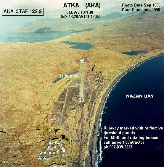
English: Annotated aerial photograph of Atka Airport (FAA: AKA) in Alaska, United States. |
| Date | Photo: September 1996, Data: June 1998 |
| Source |
|
| Author | Federal Aviation Administration, Alaskan Region |
| Permission (Reusing this file) |
Public domain |
| Object location | | View this and other nearby images on: OpenStreetMap |
|---|
Licensing[edit]
This image or file is a work of a Federal Aviation Administration employee, taken or made as part of that person's official duties. As a work of the U.S. federal government, the image is in the public domain in the United States.
|
 |
File history
Click on a date/time to view the file as it appeared at that time.
| Date/Time | Thumbnail | Dimensions | User | Comment | |
|---|---|---|---|---|---|
| current | 19:30, 1 March 2008 | | 554 × 565 (56 KB) | Zyxw (talk | contribs) | smaller file size |
| 19:12, 1 March 2008 |  | 554 × 565 (189 KB) | Zyxw (talk | contribs) | {{Information |Description = Aerial photo of Atka Airport (AKA) in Alaska, United States. |Source = Web site: http://www.alaska.faa.gov/fai/airports.htm <br/>Image: http://www.alaska.faa.gov/fai/images/AKPEN/AKA-c.jpg |Date = June 1998 |
You cannot overwrite this file.
File usage on Commons
There are no pages that use this file.
File usage on other wikis
The following other wikis use this file:
- Usage on arz.wikipedia.org
- Usage on ceb.wikipedia.org
- Usage on de.wikipedia.org
- Usage on en.wikipedia.org
- Usage on fa.wikipedia.org
- Usage on ja.wikipedia.org
- Usage on pl.wikipedia.org
- Usage on ro.wikipedia.org
- Usage on ru.wikipedia.org
- Usage on tg.wikipedia.org
- Usage on www.wikidata.org