File:ADS - FAA airport diagram.png
Jump to navigation
Jump to search
Size of this preview: 390 × 599 pixels. Other resolutions: 156 × 240 pixels | 516 × 792 pixels.
Original file (516 × 792 pixels, file size: 68 KB, MIME type: image/png)
Captions
Captions
Add a one-line explanation of what this file represents
Summary[edit]
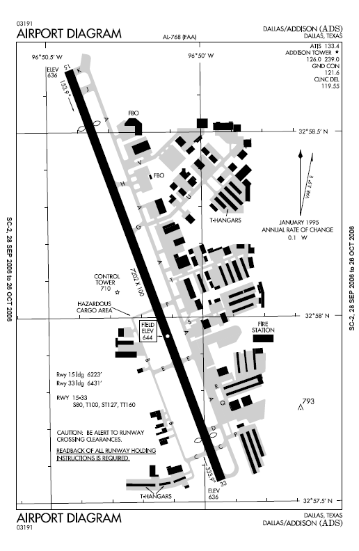
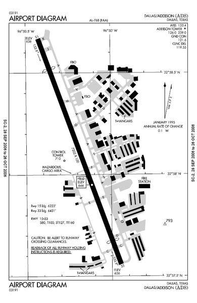
| Description | FAA airport diagram for Addison Airport (ADS) in Addison, Texas, United States. |
| Date | Effective 2006-09-28 to 2006-10-26. |
| Source |
http://www.naco.faa.gov/d-tpp/0610/00768.PDF Note: this URL changes every 28 days; the airport article should contain a link to the current FAA diagram. |
| Author | Produced by the National Aeronautical Charting Office (NACO), a department of the Federal Aviation Administration (FAA). |
| Permission (Reusing this file) |
Public domain. |
Licensing[edit]
This image or file is a work of a Federal Aviation Administration employee, taken or made as part of that person's official duties. As a work of the U.S. federal government, the image is in the public domain in the United States.
|
 |
Original upload log[edit]
Originally from en:wikipedia; description page is/was here. (All user names refer to en.wikipedia)
- 2006-10-28 01:12 MJHankel 516×792×8 (70066 bytes) Airport map Addison Airport {{PD-USGov-FAA}}
Original upload log[edit]
| date/time | username | resolution | size | edit summary |
|---|---|---|---|---|
| 16:46, 15 November 2007 | User:File Upload Bot (Magnus Manske) | 516×792 | 68 KB | {{BotMoveToCommons|en.wikipedia}} {{Information |Description={{en|Airport map Addison Airport <a href="http://en.wikipedia.org/wiki/commons:category:Addison_Airport" class="extiw" title="en:commons:category:Addison_Airport">en:commons:category:Addison Airport</a> <a href="http://en.wikipedia.org/wiki/commons:category:Federal_Aviation_Administration" class="extiw" title="en:commons:category:Federal_Aviation_Administration">en:commons:category:Federal Aviation Administration</a> <a href="http://en.wikipedia.org/wiki/commons:category:Maps" class="extiw" title="en:commons:category:Maps">en:commons:category:Maps</a>}} |Source=Originally from [htt |
File history
Click on a date/time to view the file as it appeared at that time.
| Date/Time | Thumbnail | Dimensions | User | Comment | |
|---|---|---|---|---|---|
| current | 12:23, 13 June 2008 | | 516 × 792 (68 KB) | BetacommandBot (talk | contribs) | move approved by: User:Superm401 This image was moved from Image:ADS airport map.PNG == Summary == {{Information | Description = FAA airport diagram for Addison Airport (ADS) in Addison, Texas, United States. | Source = |
You cannot overwrite this file.
File usage on Commons
There are no pages that use this file.
File usage on other wikis
The following other wikis use this file:
- Usage on en.wikipedia.org