File:ACW Corinth2Perryville.png
Jump to navigation
Jump to search

Size of this preview: 800 × 580 pixels. Other resolutions: 320 × 232 pixels | 640 × 464 pixels | 1,024 × 743 pixels | 1,280 × 928 pixels | 2,551 × 1,850 pixels.
Original file (2,551 × 1,850 pixels, file size: 888 KB, MIME type: image/png)
Captions
Captions
Add a one-line explanation of what this file represents
Summary[edit]
| Description |
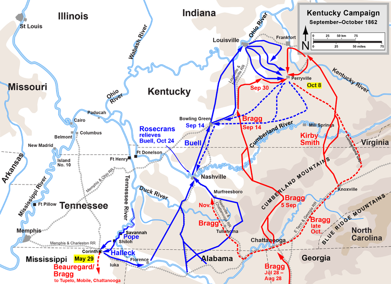
English: Map of the en:Western Theater of the American Civil War, actions from First Corinth to Perryville. Drawn by Hal Jespersen in Adobe Illustrator CS5. Graphic source file is available at http://www.posix.com/CWmaps/ |
| Date | 31 March 2006 (original upload date) |
| Source | Transferred from en.wikipedia to Commons by Legoktm. |
| Author | The original uploader was Hlj at English Wikipedia. |
Licensing[edit]
This file is licensed under the Creative Commons Attribution 3.0 Unported license.
Attribution: Map by Hal Jespersen, www.posix.com/CW
- You are free:
- to share – to copy, distribute and transmit the work
- to remix – to adapt the work
- Under the following conditions:
- attribution – You must give appropriate credit, provide a link to the license, and indicate if changes were made. You may do so in any reasonable manner, but not in any way that suggests the licensor endorses you or your use.
Original upload log[edit]
The original description page was here. All following user names refer to en.wikipedia.
- 2006-03-31 00:31 Hlj 2467×1841×8 (938977 bytes) Map of the [[Western Theater of the American Civil War]], actions from First Corinth to Perryville. Drawn by Hal Jespersen in Macromedia Freehand. Graphic source file is available at http://www.posix.com/CWmaps/ {{PD-release}}
File history
Click on a date/time to view the file as it appeared at that time.
| Date/Time | Thumbnail | Dimensions | User | Comment | |
|---|---|---|---|---|---|
| current | 22:31, 24 March 2011 | | 2,551 × 1,850 (888 KB) | Hlj (talk | contribs) | Update to new graphic style for rivers. Same license. |
| 17:39, 28 May 2010 |  | 2,551 × 1,850 (742 KB) | Hlj (talk | contribs) | Updated graphics, added legend and scale. {{cc-by-3.0|Map by Hal Jespersen, www.posix.com/CW}} Category:American Civil War Category:Maps | |
| 19:35, 1 May 2008 |  | 2,467 × 1,841 (917 KB) | File Upload Bot (Magnus Manske) (talk | contribs) | {{BotMoveToCommons|en.wikipedia}} {{Information |Description={{en|Map of the en:Western Theater of the American Civil War, actions from First Corinth to Perryville. Drawn by Hal Jespersen in Macromedia Freehand. Graphic source file is available at h |
You cannot overwrite this file.
File usage on Commons
There are no pages that use this file.
File usage on other wikis
The following other wikis use this file:
- Usage on da.wikipedia.org
- Usage on ja.wikipedia.org
- Usage on nl.wikipedia.org
- Usage on no.wikipedia.org
- Usage on pl.wikipedia.org