File:3823 - Riffelberg - View from Gornergratbahn.JPG
Jump to navigation
Jump to search

Size of this preview: 800 × 600 pixels. Other resolutions: 320 × 240 pixels | 640 × 480 pixels | 1,024 × 768 pixels | 1,280 × 960 pixels | 2,560 × 1,920 pixels | 3,648 × 2,736 pixels.
Original file (3,648 × 2,736 pixels, file size: 2.69 MB, MIME type: image/jpeg)
Captions
Captions
Add a one-line explanation of what this file represents
| Description |
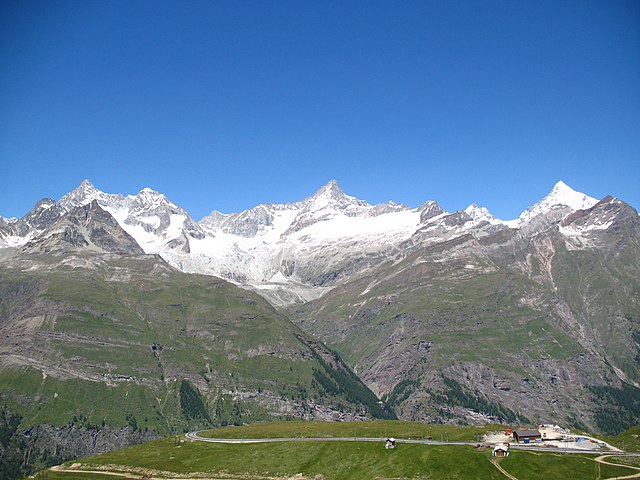
Deutsch: Ausblick von der Gornergratbahn, Riffelberg / Zermatt, Schweiz. Im Hintergrund von links nach rechts der Ober Gabelhorn (4.063 m.ü.M.), Wellenkuppe (3.903 m.ü.M.), Trifthorn (3.728 m.ü.M.), Pointe du Mountet (3.877 m.ü.M.), Zinalrothorn (4.221 m.ü.M., Bildmitte), Pointe Sud du Moming (3.963 m.ü.M.), Schahhorn (3.974,5 m.ü.M.) und Weisshorn (4.505 m). Im Vordergrund, vor den Ober Gabelhorn, liegt der Unter Gabelhorn (3.391,7 m.ü.M.). In den Grat laufend vom Zinalrothorn liegen zwei Nebengipfel, der Ober Äschhorn (3669 m.ü.M.) und der Unter Äschhorn (3.618 m.ü.M.). Weiter gibt es im Vordergrund von links nach rechts den Wisshorn (2.936 m.ü.M.), den Platthorn (3.345 m.ü.M.) und den Mettelhorn (3.406,0 m.ü.M.). Alle gehören zu den Walliser Alpen
English: View from the Gornergratbahn, Riffelberg / Zermatt, Switzerland. In the background from the left to the right the Ober Gabelhorn (4063 metres), Wellenkuppe (3903 m), Trifthorn (3728 m), Pointe du Mountet (3877 m), Zinalrothorn (4221 m, centre of the image), Pointe Sud du Moming (3963 m), Schahhorn (3974.5 m) and Weisshorn (4505 m). In the foreground, in front of the Ober Gabelhorn, lies the Unter Gabelhorn (3391.7 m). In the ridge coming from the Zinalrothorn are two side summits, the Ober Äschhorn (3669 m) and the Unter Äschhorn (3618 m). Further one can find in the foreground, from left to right, the Wisshorn (2936 m), Platthorn (3345 m) and Mettelhorn (3406.0 m). All mountains are part of the Wallis or Pennine Alps
Nederlands: Blik vanaf de Gornergratbahn, Riffelberg/Zermatt, Zwitserland. In de achtergrond van links naar rechts de Ober Gabelhorn (4063 meter), de Wellenkuppe (3903 m), de Trifthorn (3728 m), de Pointe du Mountet (3877 m), de Zinalrothorn (4221 m, midden op de foto), Pointe Sud du Moming (3963 m), Schahhorn (3974,5 m) en de Weisshorn. Op de voorgrond, voor de Ober Gabelhorn, ligt de Unter Gabelhorn (3391,7 m). In de graat lopend vanaf de top van de Zinalrothorn liggen twee neventoppen, de Ober Äschhorn (3669 m) en de Unter Äschhorn (3618 m). Verder zijn op de voorgrond, van links naar rechts, de Wisshorn (2936 m), de Platthorn (3345 m) en de Mettelhorn (3406.0 m) te zien. Alle bergen maken deel uit van de Walliser Alpen
|
||||
| Date | |||||
| Source | Own work | ||||
| Author | Andrew Bossi | ||||
| Permission (Reusing this file) |
Own work, share alike, attribution required (Creative Commons CC-BY-SA-2.5) |
I, the copyright holder of this work, hereby publish it under the following license:
This file is licensed under the Creative Commons Attribution-Share Alike 2.5 Generic license.
- You are free:
- to share – to copy, distribute and transmit the work
- to remix – to adapt the work
- Under the following conditions:
- attribution – You must give appropriate credit, provide a link to the license, and indicate if changes were made. You may do so in any reasonable manner, but not in any way that suggests the licensor endorses you or your use.
- share alike – If you remix, transform, or build upon the material, you must distribute your contributions under the same or compatible license as the original.
| Annotations | This image is annotated: View the annotations at Commons |
File history
Click on a date/time to view the file as it appeared at that time.
| Date/Time | Thumbnail | Dimensions | User | Comment | |
|---|---|---|---|---|---|
| current | 22:28, 3 November 2007 | | 3,648 × 2,736 (2.69 MB) | Thisisbossi (talk | contribs) | {{Information |Description={{de|Schauen vom die Gornergratbahn, Riffelberg / Zermatt, Schweiz}} {{en|View from the Gornergratbahn, [[:en:Riffelberg|Riffelberg |
You cannot overwrite this file.
File usage on Commons
The following 2 pages use this file:
File usage on other wikis
The following other wikis use this file:
- Usage on de.wikipedia.org
- Usage on fr.wikipedia.org
- Usage on it.wikipedia.org
- Usage on nn.wikipedia.org
- Usage on pnb.wikipedia.org