File:31.13304E 29.97858N Giza necropolis.png
Jump to navigation
Jump to search

Size of this preview: 800 × 543 pixels. Other resolutions: 320 × 217 pixels | 640 × 435 pixels | 1,022 × 694 pixels.
Original file (1,022 × 694 pixels, file size: 1.23 MB, MIME type: image/png)
Captions
Captions
Add a one-line explanation of what this file represents
| Description |
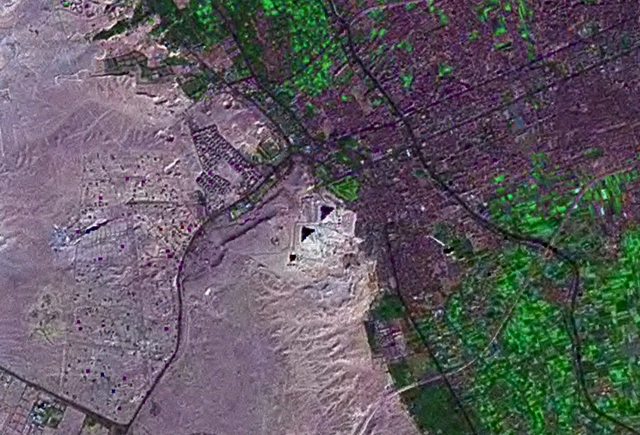
English: Giza necroplis seen from space, altitude of 8.8 km. Three black/purple triangular-shaped object near the middle of the image. Français : Vue du complexe des pyramides de l'espace. Altitude de 8,8 km |
|||
| Date | Geocover 2000 dataset | |||
| Source | Created with NASA WorldWind by User:Oaktree_b using Landsat 7 (Pseudo color) satellite image. | |||
| Author | NASA | |||
| Permission (Reusing this file) |
|

File history
Click on a date/time to view the file as it appeared at that time.
| Date/Time | Thumbnail | Dimensions | User | Comment | |
|---|---|---|---|---|---|
| current | 22:39, 16 July 2011 | | 1,022 × 694 (1.23 MB) | Oaktree b (talk | contribs) | {{Information |Description ={{en|1=Giza necroplis seen from space, altitude of 8.8 km.}} |Source =Created with NASA WorldWind by User:Oaktree_b using Landsat 7 (Pseudo color) satellite image. |Author =NASA |Date =Geocover |
You cannot overwrite this file.
File usage on Commons
There are no pages that use this file.
File usage on other wikis
The following other wikis use this file:
- Usage on fr.wikipedia.org
- Usage on ka.wikipedia.org
- Usage on ro.wikipedia.org
- Usage on xmf.wikipedia.org