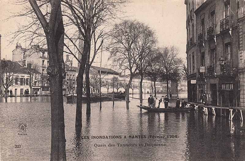
File:223. Les Inondations a Nantes (Février 1904). Quais des Tanneurs et Duquesne (February 1904) (33121074183).jpg

Original file (3,300 × 2,171 pixels, file size: 4.58 MB, MIME type: image/jpeg)
Captions
Captions
Summary[edit]
._Quais_des_Tanneurs_et_Duquesne_(February_1904)_(33121074183).jpg&action=edit§ion=1)
| Description |
Postcard. Postally unused. Published by Héliotypie Dugas et Cie, Nantes. Bought from an eBay seller in Menigoute, France. Location: <a href="https://www.google.com.au/maps/@47.2186213,-1.5567964,3a,90y,44.96h,80.69t/data=!3m6!1e1!3m4!1sCpCGBtQjn47OnvH0K6DhYA!2e0!7i13312!8i6656!6m1!1e1" rel="noreferrer nofollow">Google Maps Street View</a> Les inondations de février 1904 (The floods of February 1904) - <a href="https://translate.google.com.au/translate?hl=en&sl=fr&u=http://www.archives.nantes.fr/PAGES/RESSOURCES/actualites/inondations_1904.htm&prev=search" rel="noreferrer nofollow">translate.google.com.au/translate?hl=en&sl=fr&u=h...</a> In the 1930s and 1940s the river Erdre was filled in to create the thoroughfare Cours des 50 Otages. The old quays of the Erdre have become alleys and simple sidewalks. |
| Date | |
| Source | 223. Les Inondations a Nantes (Février 1904). Quais des Tanneurs et Duquesne (February 1904) |
| Author | pellethepoet from Sydney, Australia |
| Camera location | | View this and other nearby images on: OpenStreetMap |
|---|
._Quais_des_Tanneurs_et_Duquesne_(February_1904)_(33121074183).jpg¶ms=047.218832_N_-001.556904_E_globe:Earth_type:camera_source:Flickr_&language=en)
Licensing[edit]
._Quais_des_Tanneurs_et_Duquesne_(February_1904)_(33121074183).jpg&action=edit§ion=2)
- You are free:
- to share – to copy, distribute and transmit the work
- to remix – to adapt the work
- Under the following conditions:
- attribution – You must give appropriate credit, provide a link to the license, and indicate if changes were made. You may do so in any reasonable manner, but not in any way that suggests the licensor endorses you or your use.
| This image was originally posted to Flickr by pellethepoet at https://flickr.com/photos/47201412@N02/33121074183. It was reviewed on 3 May 2021 by FlickreviewR 2 and was confirmed to be licensed under the terms of the cc-by-2.0. |
File history
Click on a date/time to view the file as it appeared at that time.
| Date/Time | Thumbnail | Dimensions | User | Comment | |
|---|---|---|---|---|---|
| current | 15:37, 3 May 2021 | | 3,300 × 2,171 (4.58 MB) | English Roger (talk | contribs) | Transferred from Flickr via #flickr2commons |
You cannot overwrite this file.
File usage on Commons
There are no pages that use this file.
._Quais_des_Tanneurs_et_Duquesne_(February_1904)_(33121074183).jpg&oldid=764355178)