File:2024 Oklahoma Libertarian presidential primary results map by county.svg
Jump to navigation
Jump to search

Size of this PNG preview of this SVG file: 800 × 399 pixels. Other resolutions: 320 × 160 pixels | 640 × 319 pixels | 1,024 × 511 pixels | 1,280 × 638 pixels | 2,560 × 1,277 pixels | 810 × 404 pixels.
Original file (SVG file, nominally 810 × 404 pixels, file size: 32 KB)
Captions
Captions
Add a one-line explanation of what this file represents
Summary[edit]
| Description |
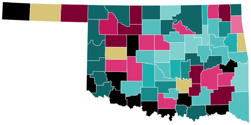
English: Results of the 2024 Oklahoma Libertarian presidential primary by county. Data from https://results.okelections.us/OKER/?elecDate=20240305.
Cyan is for Oliver; Magenta is for Hornberger. Yellow is a tie and black indicates no votes. |
| Date | |
| Source | Own work |
| Author | Elli |
Licensing[edit]

I, the copyright holder of this work, hereby publish it under the following license:
| This file is made available under the Creative Commons CC0 1.0 Universal Public Domain Dedication. | |
| The person who associated a work with this deed has dedicated the work to the public domain by waiving all of their rights to the work worldwide under copyright law, including all related and neighboring rights, to the extent allowed by law. You can copy, modify, distribute and perform the work, even for commercial purposes, all without asking permission.
|
File history
Click on a date/time to view the file as it appeared at that time.
| Date/Time | Thumbnail | Dimensions | User | Comment | |
|---|---|---|---|---|---|
| current | 21:26, 6 March 2024 | | 810 × 404 (32 KB) | Elli (talk | contribs) | Uploaded own work with UploadWizard |
You cannot overwrite this file.
File usage on Commons
The following page uses this file:
File usage on other wikis
The following other wikis use this file:
- Usage on en.wikipedia.org