File:2022 Kyiv Offensive.png
Jump to navigation
Jump to search

Size of this preview: 443 × 599 pixels. Other resolutions: 177 × 240 pixels | 355 × 480 pixels | 568 × 768 pixels | 757 × 1,024 pixels | 1,514 × 2,048 pixels | 4,437 × 6,000 pixels.
Original file (4,437 × 6,000 pixels, file size: 15.81 MB, MIME type: image/png)
Captions
Captions
Add a one-line explanation of what this file represents
Summary[edit]
| Description |
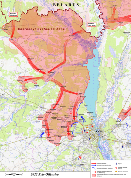
বাংলা: ২০২২ সালে কিয়েভ আক্রমণের মানচিত্র, রুশ-ইউক্রেনীয় যুদ্ধের সময়। ওপেনটোপোম্যাপ ডেটা ব্যবহার করে তৈরি। English: Map of the 2022 Kyiv offensive, during the Russo-Ukrainian War. Made using OpenTopoMap data. |
| Date | |
| Source | Own work |
| Author | Rr016 |
Licensing[edit]
I, the copyright holder of this work, hereby publish it under the following license:
This file is licensed under the Creative Commons Attribution-Share Alike 4.0 International license.
- You are free:
- to share – to copy, distribute and transmit the work
- to remix – to adapt the work
- Under the following conditions:
- attribution – You must give appropriate credit, provide a link to the license, and indicate if changes were made. You may do so in any reasonable manner, but not in any way that suggests the licensor endorses you or your use.
- share alike – If you remix, transform, or build upon the material, you must distribute your contributions under the same or compatible license as the original.
File history
Click on a date/time to view the file as it appeared at that time.
| Date/Time | Thumbnail | Dimensions | User | Comment | |
|---|---|---|---|---|---|
| current | 23:37, 9 June 2022 | | 4,437 × 6,000 (15.81 MB) | Rr016 (talk | contribs) | Small corrections and changes |
| 23:38, 11 May 2022 |  | 4,437 × 6,000 (15.74 MB) | Rr016 (talk | contribs) | Minor changes | |
| 22:32, 4 April 2022 |  | 4,437 × 6,000 (15.76 MB) | Rr016 (talk | contribs) | Adjusted frame of map, Included early Russian infiltration attempts, Corrected occupied territory | |
| 21:37, 20 March 2022 |  | 4,017 × 6,000 (16.47 MB) | Rr016 (talk | contribs) | Corrections to lines of contact, Makariv under Ukrainian control, Included Russian airborne attempt on Vasylkiv airbase, Reduced map size | |
| 22:22, 14 March 2022 |  | 5,356 × 8,000 (18.51 MB) | Rr016 (talk | contribs) | Uploaded own work with UploadWizard |
You cannot overwrite this file.
File usage on Commons
The following 11 pages use this file:
- User:Jcornelius/Angola/2022 April 1-10
- User:Jcornelius/Angola/2022 June 1-10
- User:Jcornelius/Angola/2022 March 11-20
- User:Jcornelius/Angola/2022 May 11-20
- User:Magog the Ogre/Maps of conflicts/2022 April
- User:Magog the Ogre/Maps of conflicts/2022 June
- User:Magog the Ogre/Maps of conflicts/2022 March
- User:Magog the Ogre/Maps of conflicts/2022 May
- User:Rr016
- User talk:Rr016
- Category:Battle of Moshchun
File usage on other wikis
The following other wikis use this file:
- Usage on en.wikipedia.org
- Usage on es.wikipedia.org
- Usage on et.wikipedia.org
- Usage on eu.wikipedia.org
- Usage on fr.wikipedia.org
- Usage on id.wikipedia.org
- Usage on lv.wikipedia.org
- Usage on ru.wikipedia.org
- Usage on uk.wikipedia.org
- Usage on www.wikidata.org