File:2020 PAGASA Siony forecast map.png
Jump to navigation
Jump to search
Size of this preview: 776 × 600 pixels. Other resolutions: 311 × 240 pixels | 621 × 480 pixels | 994 × 768 pixels | 1,280 × 989 pixels | 2,560 × 1,978 pixels | 3,300 × 2,550 pixels.
Original file (3,300 × 2,550 pixels, file size: 492 KB, MIME type: image/png)
Captions
Captions
Add a one-line explanation of what this file represents
Summary[edit]
| Description |
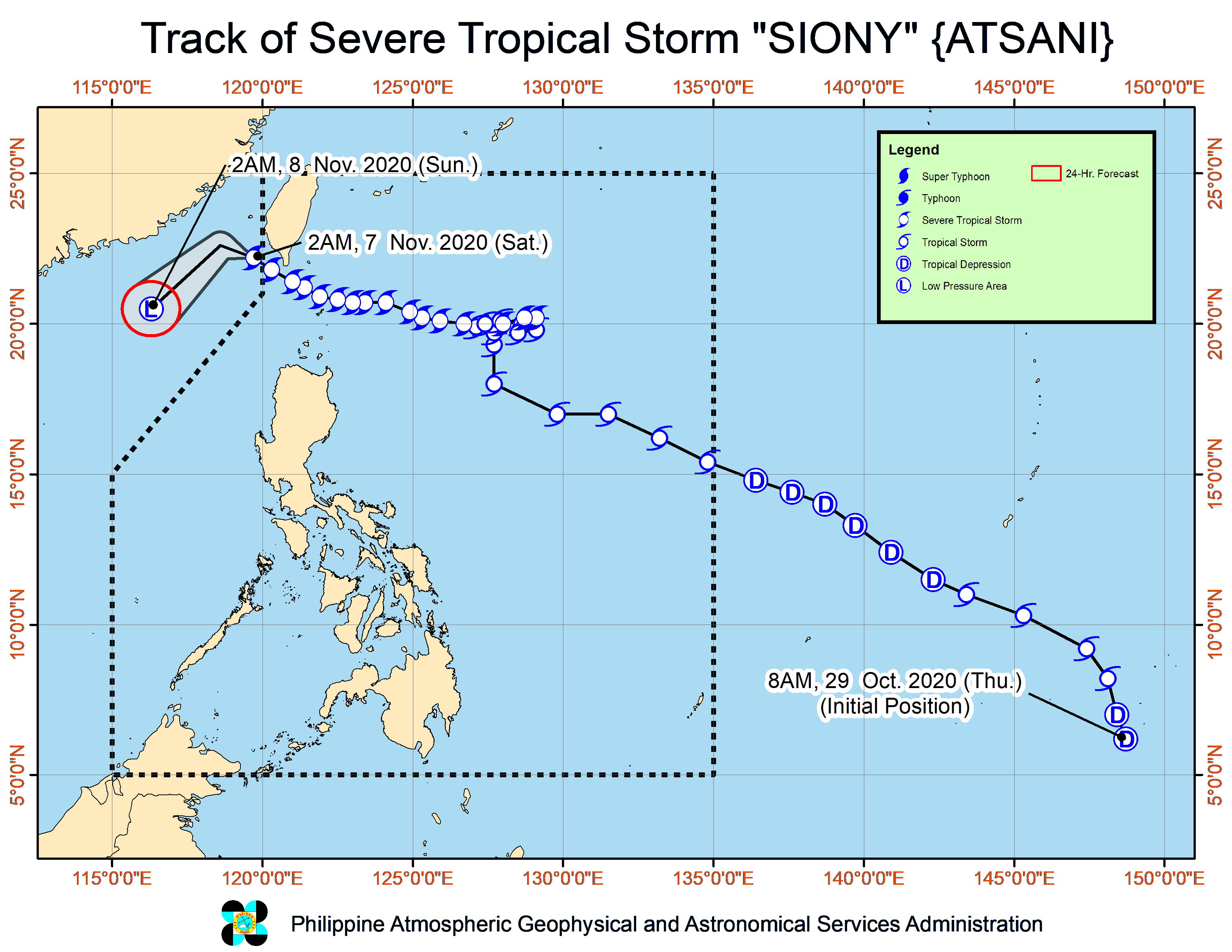
English: PAGASA's forecast map of Northwest Pacific tropical storm Siony #1. |
| Date | |
| Source | http://bagong.pagasa.dost.gov.ph/tropical-cyclone/severe-weather-bulletin/2 https://pubfiles.pagasa.dost.gov.ph/tamss/weather/track_siony.png |
| Author | PAGASA |
Licensing[edit]
| This work is in the public domain in the Philippines and possibly other jurisdictions because it is a work created by an officer or employee of the Government of the Philippines or any of its subdivisions and instrumentalities, including government-owned and/or controlled corporations, as part of their regularly prescribed official duties; consequently, any work is ineligible for copyright under the terms of Part IV, Chapter I, Section 171.11 and Part IV, Chapter IV, Section 176 of Republic Act No. 8293 and Republic Act No. 10372, as amended, unless otherwise noted. However, in some instances, the use of this work in the Philippines or elsewhere may be regulated by this law or other laws.
|

|
File history
Click on a date/time to view the file as it appeared at that time.
| Date/Time | Thumbnail | Dimensions | User | Comment | |
|---|---|---|---|---|---|
| current | 21:35, 6 November 2020 | | 3,300 × 2,550 (492 KB) | Cewbot (talk | contribs) | Import PAGASA tropical cyclone forecast map of Northwest Pacific severe tropical storm Siony #24. At 4:00 AM today, the center of Severe Tropical Storm "SIONY" was estimated based on all available data at 295 km Northwest of Itbayat, Batanes (OUTSIDE PAR) (22.4 °N, 119.6 °E ) (2020-11-06 21:00 UTC) |
| 15:34, 6 November 2020 |  | 3,300 × 2,550 (516 KB) | Cewbot (talk | contribs) | Import PAGASA tropical cyclone forecast map of Northwest Pacific severe tropical storm Siony #23. At 10:00 PM today, the center of Severe Tropical Storm "SIONY" was estimated based on all available data at 225 km Northwest of Itbayat, Batanes (22.0 °N, 120.1 °E ) (2020-11-06 15:00 UTC) | |
| 09:36, 6 November 2020 |  | 3,300 × 2,550 (519 KB) | Cewbot (talk | contribs) | Import PAGASA tropical cyclone forecast map of Northwest Pacific severe tropical storm Siony #22. At 4:00 PM today, the center of Severe Tropical Storm "SIONY" was estimated based on all available data at 145 km West Northwest of Itbayat, Batanes (21.5 °N, 120.7 °E ) (2020-11-06 09:00 UTC) | |
| 06:35, 6 November 2020 |  | 3,300 × 2,550 (518 KB) | Cewbot (talk | contribs) | Import PAGASA tropical cyclone forecast map of Northwest Pacific severe tropical storm Siony #21. At 1:00 PM today, the center of Severe Tropical Storm "SIONY" was estimated based on all available data at 95 km Northwest of Itbayat, Batanes (21.3 °N, 121.1 °E ) (2020-11-06 06:00 UTC) | |
| 05:34, 6 November 2020 |  | 3,300 × 2,550 (517 KB) | Cewbot (talk | contribs) | Import PAGASA tropical cyclone forecast map of Northwest Pacific severe tropical storm Siony #20. At 10:00 AM today, the center of Severe Tropical Storm "SIONY" was estimated based on all available data at 50 km Northwest of Itbayat, Batanes (21.1 °N, 121.5 °E ) (2020-11-06 03:00 UTC) | |
| 03:35, 6 November 2020 |  | 3,300 × 2,550 (519 KB) | Cewbot (talk | contribs) | Import PAGASA tropical cyclone forecast map of Northwest Pacific severe tropical storm Siony #20. At 10:00 AM today, the center of Severe Tropical Storm "SIONY" was estimated based on all available data at 50 km Northwest of Itbayat, Batanes (21.1 °N, 121.5 °E ) (2020-11-06 03:00 UTC) | |
| 00:36, 6 November 2020 |  | 3,300 × 2,550 (535 KB) | Cewbot (talk | contribs) | Import PAGASA tropical cyclone forecast map of Northwest Pacific severe tropical storm Siony #19. At 7:00 AM today, the center of Severe Tropical Storm "SIONY" was estimated based on all available data at 30 km East Northeast of Itbayat, Batanes (20.9 °N, 122.1 °E ) (2020-11-06 00:00 UTC) | |
| 21:36, 5 November 2020 |  | 3,300 × 2,550 (541 KB) | Cewbot (talk | contribs) | Import PAGASA tropical cyclone forecast map of Northwest Pacific severe tropical storm Siony #18. At 4:00 AM today, the center of Severe Tropical Storm "SIONY" was estimated based on all available data at 60 km East Northeast of Basco, Batanes or 70 km East of Itbayat, Batanes (20.7 °N, 122.5 °E ) (2020-11-05 21:00 UTC) | |
| 18:35, 5 November 2020 |  | 3,300 × 2,550 (546 KB) | Cewbot (talk | contribs) | Import PAGASA tropical cyclone forecast map of Northwest Pacific severe tropical storm Siony #17. At 1:00 AM today, the center of Severe Tropical Storm "SIONY" was estimated based on all available data at 125 km East Northeast of Basco, Batanes (20.8 °N, 123.1 °E ) (2020-11-05 18:00 UTC) | |
| 15:35, 5 November 2020 |  | 3,300 × 2,550 (545 KB) | Cewbot (talk | contribs) | Import PAGASA tropical cyclone forecast map of Northwest Pacific severe tropical storm Siony #16. At 10:00 PM today, the center of Severe Tropical Storm "SIONY" was estimated based on all available data at 170 km East of Basco, Batanes (20.7 °N, 123.6 °E ) (2020-11-05 15:00 UTC) |
You cannot overwrite this file.
File usage on Commons
There are no pages that use this file.